
1. Introduction
In 1928, Shotaro Kentaro of Japan once said in Toshika Taniguchi’s Travel Praise and Salute that travel is a basic demand in people’s life and reflects human civilization. At the same time, he also said that when traveling, it is more important than money to know the information of mountains, scenic spots, relics, shrines, legends or origins of Buddhist temples (Seo, 2005). In other words, the role of the guidebook is to make yourself an encyclopedia of knowledge about the destination you want to see. In addition, tourists can learn more information about the scenic spots and imagine what they could see in the area through guidebooks. By this, the initial impressions of tourists are determined. In this sense, a guidebook is a detailed instruction for understanding general or special information of relevant areas and learning local multi-cultures (Ahn and Park, 2015).
In addition, according to the sales survey of books in China, the sales of scenic spots guidebooks account for 46% of the total sales of tourist books(https://www.bbtnews.com.cn/2014/1107/58514.shtml). Guidebooks can provide detailed landscape information and travel routes, so they are often used when making travel plans. The reason why guidebooks are welcomed by people is that they are more visible than other commercial propaganda and can provide a lot of detailed and accurate information about scenic spots.
What’s more, idioms related to Mount Tai such as “as heavy as Mount Tai (重如泰山)”, “Mount Tai and the North Star (泰山北斗)”, and “as steady as Mount Tai (稳如泰山)” have appeared both in China and Korea. From this, it can be seen that Mount Tai is often used as a metaphor for things of great value, respected and admired figures, and inviolable status, etc. (Lee, 2018). Mount Tai has been the object of Chinese emperors pilgrimage for two thousand years. It used to be known as a world famous mountain, and it is a well-known excellent scenic spot. However, recently, Mount Tai scenic spot is becoming a tourist resort for economic development, just like other scenic areas. And the landscape traces of “Yunlong Sanxian (雲龍三現)” and “Yangtian Wangfo (仰天望佛)” in the past have gradually disappeared (Yu and Jung, 2021). With the development of the relationship between Mount Tai and human beings and the evolvement of modern civilization, it is necessary to explore what is the image and significance of Mount Tai in the eyes of the landscape propagandists of the guidebooks introducing Mount Tai.
Therefore, the purpose of this study is to investigate the landscape characteristics of Mount Tai by analyzing the landscape types and elements, the Kernel Density, Mean Center and Standard Deviational Ellipse of the landscape elements appearing in the guidebooks introducing Mount Tai.
2. Theoretical Study
Kang et al. (2007), Arima (2015), Askawa and Okano (2008) and Shibasaki (2019) in Japan learned about the image of tourist destinations from the perspectives of scenic spots’s resources, atmosphere, and tourist activities by analyzing the contents of guidebooks. Ahn and Park (2015), Seo (2009) and others analyzed the reorganization process of tourism space in the content of the guidebooks, its connotation and meaning, and the symbolism of tourism resources. Han (2019), Hanamura (2001), and Okano et al. (2001) analyzed the characteristics of changes over a long period of time by analyzing the contents of guidebooks. Keaisumi and Nakai (2016) took Hakone (箱根) from Meiji (明治) 22 to Heisei (平成) 14 as the research object, and pointed out the impact of modern transportation in guidebooks on landscape appreciation. Lin (2009) analyzed the changes of social customs in Fuzhou (福州) as a modern city by using the guidebooks such as Fuzhou Essentials (福州要览) and The Latest Fuzhou Guidebook (最新的福州指南). The above research used the guidebooks to obtain the development and changes of the city and society, and the image and significance of scenic spots. But most of the analysis revolved around analysis in terms of tourism or culture, not so much in terms of landscape.
Compared to other research materials, texts can more accurately express the author’s views and intentions while being free from the constraints of time and space. Meanwhile, it is easier to provide readers with more relaxed and authentic perception of the experience and landscape context (Eric, 1961). Mount Tai is a famous mountain in China. From the past to the present, it has been deeply loved by Chinese people. At the same time, the texts related to Mount Tai landscape are very rich. Therefore, based on the different subjects of text writing (landscape enlighteners, landscape appreciators, and landscape propagandists), this study attempts to discuss the similarities and differences of different social groups on the landscape experience characteristics of Mount Tai. Poems are texts written by poets or celebrities about famous landscapes (Yu, 2023). According to Kato et al.(2001) in Japan, poetic texts not only contain a large number of human environments and landscapes, but also reflect macro-regional images and symbolic meanings, embodying the understanding of landscape enlighteners. User comments are texts that people spontaneously generate on social media. Through these, we can understand the objective preferences and feelings of landscape appreciators. Guidebooks are representative texts prepared by the management directors for the purpose of promoting tourist attractions. For travelers, guidebooks are encyclopedias that can provide the location and journey of specific scenic spots. That is, through the guidebook, we can understand what the landscape propagandists promote and emphasize in the tourist attractions. In other words, a guidebook is a way to understand what a landscape propagandist is promoting and emphasizing in a tourist attraction.
In addition, Yu and Jung (2021) derived the landscape types and elements of Mount Tai and the characteristics of spatial distribution of landscape elements from the perspective of landscape enlighteners (poets or celebrities) by using poems written by poets or celebrities, and Yu and Jung (2022) used the texts spontaneously generated by tourists in big data to master the landscape characteristics of modern Mount Tai from the perspective of landscape appreciators, which inspired us to improve the research on the landscape characteristics of Mount Tai from the perspective of Mount Tai landscape propagandists. Therefore this study analyzes the landscape characteristics of Mount Tai that appear in the representative guidebooks made by the landscape propagandists.
3. Research Scope and Methodology
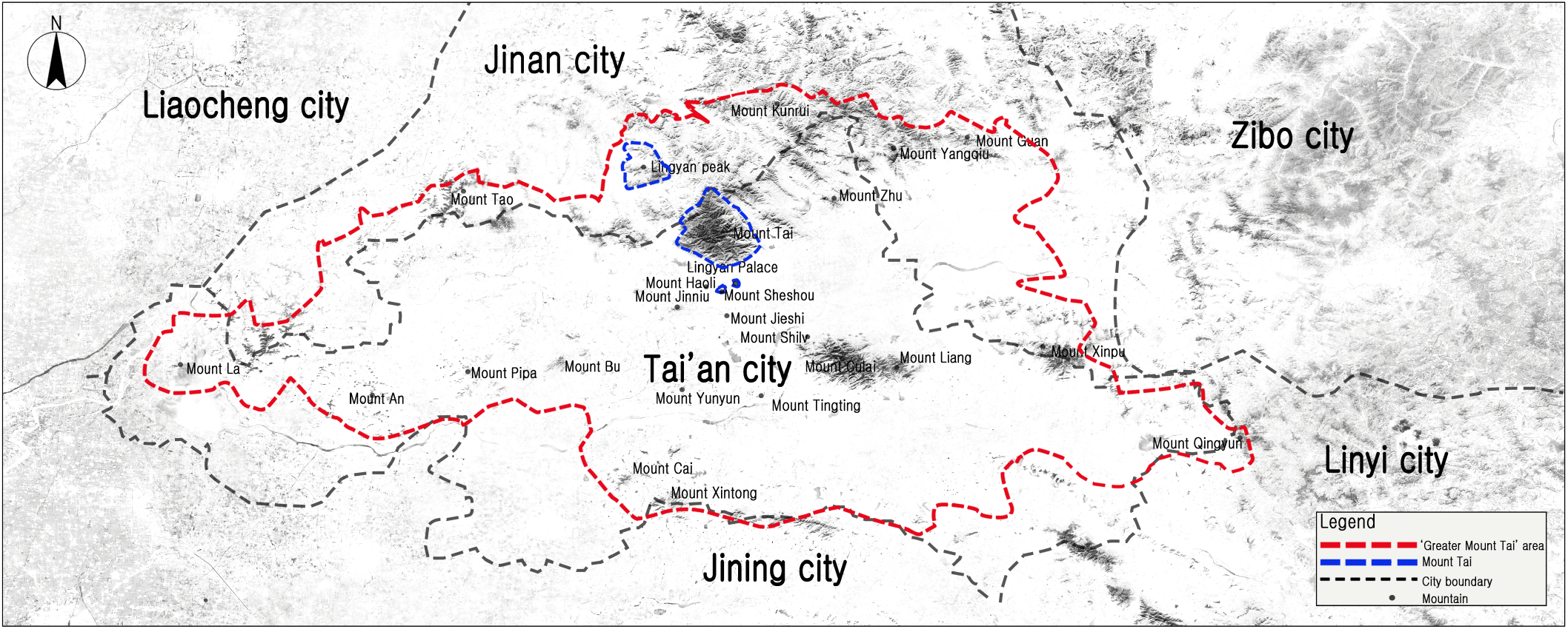
The study of the history of Mount Tai should be carried out in the range of “Great Mount Tai (大泰山)” area under the historical culture of the mountains in Tai’an (泰安) and Jinan (濟南). This area is influenced by Mount Tai culture and landscape architecture and is also the reference area of Mount Tai scholars in researching Mount Tai history and culture(Qu and Zhou, 2005). The modern Mount Tai scenic spot includes Mount Tai in Tai’an City, Haoli Mountain (蒿里山), Lingying palace[靈應宮 (Bixia Yuanjun (碧霞元君)’s temple at the foot of Mount Tai], and Lingyan Mountain (靈巖山) in Licheng District (历城区), Jinan City (Xu, 2019). Figure 1 shows the spatial scale of this study that is limited to the historical and cultural “Great Mount Tai” region.
During the 60 years from the establishment of the People’s Republic of China (PRC) (1949) to the present time (2010s), the analysis method and process of the landscape characteristics of Mount Tai in the guidebooks developed to promote the landscape of Mount Tai are as follows. First, a total of 10 guidebooks made to promote the landscape of Mount Tai were collected. Second, referring to the previous research, after refining the guidebook data, the frequency of landscape elements was derived by using ROST-CM6. Third, the landscape elements were classified into natural landscape, artificial landscape and human activities, and the landscape types and characteristics of landscape elements were analyzed by time series. The fourth part is to introduce the landscape elements of the geographic location information that can be obtained in the guidebooks into GIS, and master the spatial distribution characteristics through Kernel Density1), Mean Center, and Standard Deviational Ellipse analysis.
In order to objectively analyze the landscape characteristics of Mount Tai, the type of landscape guidebook is limited to the official landscape guidebook of Mount Tai scenic spot, which is mainly edited by the Management Office of Mount Tai scenic spot and published by China or Shandong Province (山东省) Tourism (Travel) Book Special Publishing House. A total of 10 guidebooks2) were collected from the 1950s to the 2010s for analysis.
Firstly, the collected guidebooks were quantified by using CS Scanner (CamScanne). Secondly, since the main point of view of this study is to understand the landscape characteristics of Mount Tai, specific instructions on public transportation routes that are not related to the description of the landscape or the introduction of individual tourist service facilities (accommodation, restaurants, shopping, food, etc.) were excluded.
As shown in Table 1, a total of 32,858 vocabulary data (2,416, 6,656, 5,734, 10,307, 7,745) were obtained by separating the guidebook text data. In order to ensure the unity of data and the accuracy of statistics, the separated 32,858 vocabulary data were refined as follows. ① Grammatical auxiliary words, pronouns, adverbs of degree, and location words and quantifier without specific meaning. ② Vocabularies not related to landscape description or landscape experience. ③ Synonyms that appeared repeatedly were replaced and excluded, and only one word is left for words with the same meaning (Kang et al., 2007; Woo and Suh, 2017; Zhang et al., 2021; Li and Son, 2018). After this series of refining processes, a total of 28,789 (1,891, 5,651, 5,039, 9,346, 6,862) vocabulary data, and a total of 4,069 (525, 1,005, 695, 961, 883) vocabulary data were refined. And after excluding repeated duplicate vocabulary categories data, the final vocabulary categories data used for analysis are 1,857, and the frequency is 14,651.
Notes: ① classical statements; ② vocabulary for modern texts; ③ meaningless grammatical words; ④ words unrelated to landscape description; ⑤ synonyms (同義詞); (a)= ① + ②; (b)= ③ + ④ + ⑤, (c)= (a) − (b)
4. Results and Discussion
In order to master the characteristics of landscape types, the obtained 4,069 vocabulary data were divided into natural landscapes, artificial landscapes, and human activities referring to Table 2.
Notes: this table was remade after referring to Park and Jung (2021)
N: number of landscape elements; p: proportion
According to the analysis results, the landscape characteristic of Mount Tai shown in the guidebooks is dominated by natural landscapes (1,551, 38.1%), supplemented by human activities (1,317, 32.4%) and artificial landscapes (1,201, 29.5%). This result is different from what was shown in poems and Big Data analysis which proposed that the landscape characteristics of Mount Tai are dominated by human activities (Yu and Jung, 2021; 2022). In terms of the subdivided landscape types, there are more topography (15.0%) and plants (9.7%) in natural landscape, buildings (11.9%) and structures (14.2%) in artificial landscape, and image (7.0%), semantics (7.0%), and human beings (6.9%) in human activities. Overall, the order of proportion is topography, structures, buildings, plants, semantics, image, human beings, waterscape.
From the perspective of time series, from the 1950s to the 2010s, the proportion of natural landscape of Mount Tai is 39.6%, 39.7%, 36.8%, 37.1%, and 37.5%, without much change. The proportion of artificial landscape decreased from 31.8% (1950s) to 28.5% (2010s), and the proportion of human activities increased from 28.6% (1950s) to 34.0% (2010s). It can be seen that in the whole period, the natural landscape is the most important, and the closer to 2010s, the more attention is paid to human activities. In terms of the subdivided landscape types, topography, structures, and buildings have nothing to do with time, and the rankings have always been in the top three. In addition, as the time close to the 2010s, the proportion of plants increased from 6.5% (1950s) to 10.9% (2010s), showing the largest growth trend, followed by human beings from 5.2% (1950s) to 8.0% (2010s), semantics from 5.1% (1950s) to 6.5% (2010s), and action from 4.2% (1950s) to 5.5% (2010s). It can be seen that the guidebook puts more emphasis on the natural and artificial landscape such as the topography, structures and buildings of Mount Tai, as well as semantics, human beings and action.
The characteristics of landscape types that appear in the guidebooks are shown as that Mount Tai is dominated by natural landscapes, supplemented by human activities and artificial landscapes. In terms of the subdivided landscape types, landscape elements that appeared more are topography, structures, buildings, plants, semantics, image, human beings, and waterscape respectively, based on their proportion of appearance. And from the perspective of time series, in all periods, natural landscapes is the most important, and the closer to the 2010s, the more important human activities is. In addition, topography, structures, and buildings have always been in the top three regardless of time, and the closer to the 2010s, the more emphasis is placed on plants, human beings, semantics, and action.
From the perspective of landscape types, among the natural landscape, the most frequent landscape elements in all periods include “the summit of Mount Tai” (167) in topography, “pine trees” (151) in plants, “streams” (198) and “springs” (137) in waterscape, “stone inscription” (176) in the relics of artificial landscapes, “emperor” (154) in human beings, “Fengshan (封禅)” (137) in belief and “majestic” in image (155) of human activities referring to Table 3. On the whole, the landscape elements that appeared in Mount Tai are “streams” (198), “stone inscription” (176), “the summit of Mount Tai” (167), “cliff” (166), “majestic” (155), “emperor” (154), “pine tree” (151), “Fengshan” (137), “springs” (137), “waterfall” (122) respectively, based on the frequency of appearance.
From the perspective of time series, the results of the landscape elements of Mount Tai appearing in the guidebooks show that among the natural landscape, “the summit of Mount Tai”, “peaks”, “cliffs” in topography and “streams” in waterscape appeared relatively frequently in all periods. It can be seen that the guidebooks emphasize the topography and waterscape landscape of Mount Tai. “Fengshan” and “sacrifice (祭祀)” in belief of human activities, and “legends” in semantics appeared frequently from the 1950s to the 1980s, and after the 1990s, “climbing” and “overlooking” in action appeared relatively more frequently. This is related to the facts that PRC was founded in the early 1950s and then Mount Tai was included in the World Heritage List in the 1980s, thus further emphasizing the historical and cultural value of Mount Tai, as well as the fact that since the 1990s, Tai’an City has held Mount Tai International Mountaineering Festival to establish an international city image and enrich national life. Therefore, it can be concluded that in the 1950s and 1980s, “Fengshan”, “sacrifice” and semantics were emphasized in the beliefs of human activities on Mount Tai, and after the 1990s, more emphasis was placed on “climbing” and “overlooking” in action of human activities.
In addition, the frequency of “The Most Revered of the Five Sacred Mountains (五岳独尊)”3) in image has increased significantly since the 1990s, ranking third in the whole time. From this, it can be concluded that after Mount Tai was listed in the World Heritage List in 1987, the image of Mount Tai as a national mountain “The Most Revered of the Five Sacred Mountains” became more prominent (Liu and Zheng, 2010).
Summarizing the characteristics of the landscape elements in the guidebooks introducing Mount Tai, it can be found that the sequence of landscape elements is “streams”, “stone inscription”, “the summit of Mount Tai”, “cliff”, “majestic”, “emperor”, “pine tree”, “Fengshan”, “springs”, “waterfall” successively based on their frequency of appearance. From the perspective of time series, “Fengshan” and “sacrifice” in beliefs and “legends” in semantics appeared relatively more frequently in the 1950s and 1980s, and “climbing” and “overlooking” in action after the 1990s appeared relatively more frequently.
According to the time series, the landscape elements that can obtain geographic coordinates in the guidebooks are shown in Table 4. 135 in the 1950s, 154 in the 1980s, 142 in the 1990s, 121 in the 2000s, and 101 in the 2010s, 653 landscape elements were derived. A total of 181 landscape elements were obtained after removing the repeated landscape elements. The spatial distribution analysis results are shown in Figure 2.
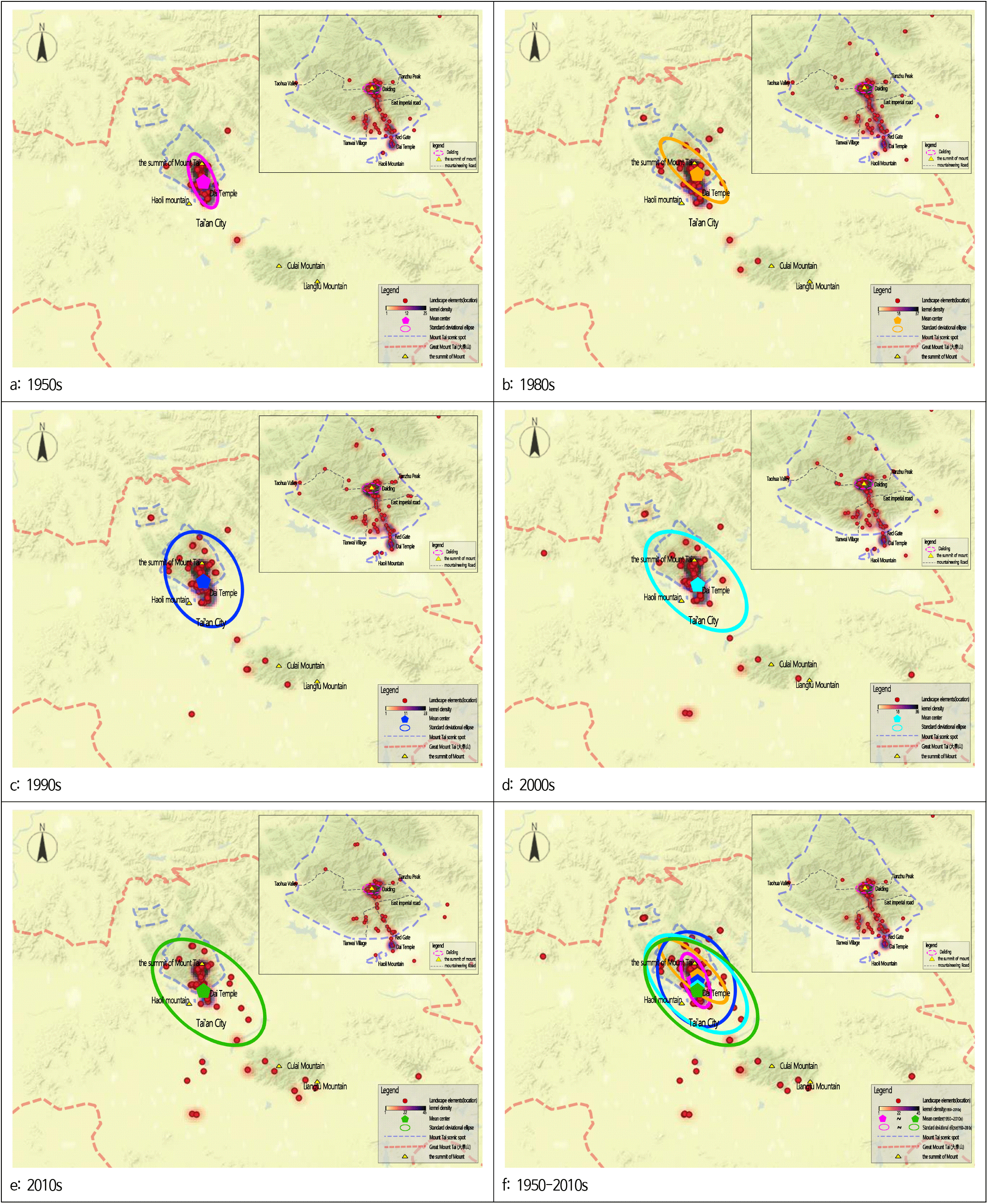
In order to investigate the concentration of Mount Tai landscape elements appearing in guidebooks in different periods, Kernel Density analysis was performed according to the frequency of landscape elements (Figure 2 (a) - (f)). From the perspective of time series, “the summit of Mount Tai”, “Dai Temple”, “Red Gate Palace”, and ”Baizhang cliff” appeared most frequently in the 1950s (Figure 2 (a)), and in the 1980s (Figure 2 (b)) and 1990s (Figure 2 (c)) “the summit of Mount Tai”, “Dai Temple”, “Eighteen Pan”, and “South Gate to Heaven” appeared most frequently. In the 2000s (Figure 2 (d)) and 2010s (Figure 2 (e)), the landscape elements of “the summit of Mount Tai”, “South Gate to Heaven”, “Bixia Temple (碧霞祠)”, and “Dai Temple (岱廟)” appeared most frequently. In all periods (Figure 2 (f)), the more frequent elements “the summit of Mount Tai”, “South Gate to Heaven”, “Eighteen Pan”, “Bixia Temple” are located in the area higher than the South Gate to Heaven of Mount Tai, which is also known as Daiding (岱顶) of Mount Tai (Li, 1987). In addition, Dai Temple is the place where the emperors of all dynasties held the Fengshan ceremony and offered sacrifices to the gods of Mount Tai. The landscape elements appearing in the guidebooks are mainly distributed in Mount Tai Daiding and Dai Temple centering on “the summit of Mount Tai”. This result is consistent with the results obtained from the analysis of poems and big data (Yu and Jung, 2021; Yu and Jung, 2022). Therefore, Mount Tai Daiding centering on “the summit of Mount Tai” and Dai Temple space are very important and needs to be protected in the future.
Mean Center analysis was conducted to understand the center changes of Mount Tai landscape elements. From the perspective of time series, the mean center in the 1950s (Figure 2 (a)) was located between “the summit of Mount Tai” and the “Red Gate”, while in the 1980s (Figure 2 (b)) and 1990s (Figure 2 (c)), the location did not change much, gradually moving southward compared with that in the 1950s. In the 2000s (Figure 2 (d)) and 2010s (Figure 2 (e)) the mean center continued to move southward, close to the Tai ’an urban area. In all periods, the mean center of landscape elements is located on the south side of the summit of Mount Tai. The closer the time is to the 2010s, the more approaching the location is to Tai’an City from the summit of Mount Tai and the middle of “Red Gate”.
Standard Deviational Ellipse analysis was conducted to understand the spatial distribution of Mount Tai landscape elements in different time series. The results showed that in the 1950s (Figure 2 (a)), the eccentricity was 0.80, representing that the landscape elements were concentrated in Red Gate Mountaineering roads, and Tianwai Village scenic spot. In the 1980s (Figure 2 (b)), the eccentricity was 0.77, representing that the landscape elements were mainly distributed in Red Gate mountaineering road. However, compared with the 1950s, the landscape elements on the mountaineering roads of Tianwai Village (天外村), Taohua Valley (桃花峪) and Tianzhu Peak (天烛峰) gradually increased. In the 1990s (Figure 2 (c)), the eccentricity was 0.60, showing that the landscape elements exhibited in the form of scattered distribution in the four mountaineering roads of Red Gate, Tianwai Village, Taohua Valley, Tianzhu Peak and Culai Mountain (徂徕山). The eccentricities in the 2000s (Figure 2 (d)) and 2010s (Figure 2 (e)) were 0.63 and 0.66, displaying that the landscape elements appeared in the form of scattered distribution not only in the mountain area of Mount Tai, but also in the urban area of Tai’an.
Summarizing the spatial distribution characteristics of Mount Tai’s landscape elements in the guidebooks, Daiding and Dai Temple are the most concentrated in all periods. As the time closer to the 2010s, the mean center gradually approaches the urban area of Tai’an from the middle of the summit of Mount Tai and the Red Gate. In addition, the landscape elements has changed from a concentrated distribution form in Mount Tai scenic spot to a scattered spatial distribution form including Mount Tai and Tai ’an urban area.
5. Conclusion
In order to master the landscape characteristics of Mount Tai, this study analyzed the landscape types and elements characteristics of Mount Tai by time series, and analyzed the spatial distribution of landscape elements in guidebooks. The conclusions of this study are summarized as follows.
Firstly, the characteristics of landscape types shown in the guidebooks are dominated by natural landscapes (37.0%), supplemented by human activities (33.8%) and artificial landscapes (29.2%). This result is different from what was shown in poems and Big Data, which proposed that the landscape characteristics of Mount Tai are dominated by human activities (Yu and Jung, 2021; Yu and Jung, 2022). Moreover, cultural researchers on Mount Tai pointed out that one of the important reasons why Mount Tai is so famous is the unique Mount Tai culture and spirit, which is more important than a physical landscape. However, this is inconsistent with our finding that the landscape characteristics of Mount Tai are dominated by nature landscapes (Dai and Zhang, 1982; Chen, 2010). That is to say, there are obvious differences on the views and preferences of landscape characteristics among the propagandists (managers) of Mount Tai scenic spot, the enlighteners (poets or celebrities), the landscape appreciators (tourists) of Mount Tai scenic spot, and the cultural researchers. This enlightens us that when improving the guidebooks of Mount Tai, we should not only focus on improving the existing charm of Mount Tai landscape, but also on the coordinated development focusing on the participation of landscape activities or the significance of the landscape. This will contribute to the sustainable development of Mount Tai Scenic Spot.
Secondly, from the perspective of subdivided landscape types, the landscape elements that appeared in Mount Tai are topography (14.7%), structures (14.2%), buildings (11.9%), plants (9.7%), semantics (7.6%), huamn beings (7.4%), image (7.2%) orderly based on the proportion of landscape elements. It can be seen that the guidebook emphasizes the natural and artificial landscape such as the topography, structures and buildings of Mount Tai, as well as the semantics, human beings and image.
Thirdly, from the perspective of landscape elements, “Fengshan” and “sacrifice” in beliefs and “legends” in semantics appeared relatively more frequently in the 1950s and 1980s, and “climbing” and “overlooking” in action of human activities after the 1990s appeared relatively more frequently. It can be seen that in the 1950s and 1980s, Mount Tai belief activities (“Fengshan”, “sacrifice”) and semantics were emphasized, and after the 1990s, more attention was paid to action.
Fourthly, the characteristics of spatial distribution are that in all periods, the landscape elements of Mount Tai were the most concentrated on the Daiding and Dai Temple. This result is consistent with the results obtained from the analysis of poems and big data (Yu and Jung, 2021; 2022). The closer it is to the 2010s, the more approaching the mean center is to Tai’an urban area from the summit of Mount Tai and the middle of Red Gate. In addition, the landscape elements have changed from the concentrated distribution form of Mount Tai scenic spot to the scattered distribution form including Mount Tai and Tai’an urban area. This is related to the Chinese government’s urban development strategy of integrating mountains and cities with the advancement of urbanization in China after the 2000s (He, 2016).
Based on the analysis results of this study, it is necessary to put forward supplementary schemes for the interaction between tourists and landscape or pay attention to tourists’ landscape experience, and make long-term plans for the coordinated development of Tai ’an City and Mount Tai landscape, instead of simply displaying or introducing the objective landscape of Mount Tai in the future. We hope that the findings of this study will contribute to enriching the landscape experience of Korea’s famous mountains.
In addition, this study only analyzes the frequency of landscape elements in guidebooks, hardly to represent all characteristics of the landscape of Mount Tai, which is the limitation of this study. But it can be found that the semantic network analysis in guidebooks is also quite important, thus it could be the subject of future research to be conducted.