
1. Introduction
Urban flood disasters are an escalating environmental concern, particularly in densely populated cities with high proportions of impermeable surfaces. Such floods often result in significant loss of life and extensive property damage. The expansion of impermeable surfaces due to urban development significantly alters the natural hydrological processes within cities, leading to increased surface runoff and frequent flooding (Li et al., 2020; Movahedinia et al., 2022). Seoul, a city with a high percentage of impervious area, has experienced a substantial increase in surface runoff from 10.6% to 51.9% between 1962 and 2010, exacerbating its vulnerability to floods. Major floods in 2010, 2011, 2018, and 2022 have caused extensive damage and ㅇunderscore the inadequacy of traditional gray infrastructure, including sewer expansions and pumping stations, that primarily depend on pipe networks.
In response, the South Korean government has shifted towards more sustainable strategies, including Low-Impact Development (LID), green infrastructure, and water-sensitive urban design. These measures are part of a broader initiative to improve water management and handle the increasing annual rainwater runoff (Shafique and Kim, 2018; Bae and Lee, 2020; Zhang et al., 2023). Since 2014, the Seoul Metropolitan Government has actively incorporated LID practices across various urban developments from residential buildings to public spaces. Yeongdeungpo-gu, a district in Seoul particularly prone to flooding due to its geographical location and high impervious surface area (96%), serves as the case study area for this research. The district has been significantly affected by intense rainfall events, with previous floods affecting thousands of households and businesses. This study aims to explore the effectiveness of LID measures in flood mitigation within this context.
This study aims to evaluate the flood mitigation efficacy of three different implementable LID-based scenarios in two specific blocks in Yeongdeungpo-gu, Seoul. The objectives include analyzing the impact of different LID practices on reducing surface runoff and peak runoff volumes during flood events. By conducting simulation-based analysis, this study determines the potential outflow reduction within these selected blocks. The outcomes are expected to provide valuable insights into the effectiveness of LID strategies for urban flood mitigation, informing urban planning and development policies aimed at enhancing resilience to flooding.
Urbanization significantly impacts watershed hydrology by increasing impervious surfaces, such as asphalt and concrete, which reduce natural infiltration and exacerbate surface runoff (Pour et al., 2020). This process often overwhelms traditional stormwater management systems, leading to urban flooding. In Seoul, the rapid expansion of impermeable surfaces has altered natural water cycles and heightened flood risks, particularly during heavy rainfall events (Shafique and Kim, 2018; Li et al., 2019). This situation is worsened by the city’s complex infrastructure and high population density that increases the vulnerability to flood-related damages. The existing grey infrastructure has proven inadequate in managing sudden and intense floods. Effective stormwater management, therefore, becomes critical in urban planning to mitigate these risks and protect both human and ecological system.
In response to the negative effects of urbanization on watershed hydrology, several nations have adopted various strategies such as water-sensitive urban design, green infrastructure, and LID techniques (Ahiablame et al., 2013; Bae and Lee, 2020). These approaches primarily aim to mitigate stormwater runoff effect, preserving ecosystems, and sustaining stormwater management systems (Bae and Lee, 2020). Over the past few decades, the adoption of LID infrastructure has emerged as a viable solution to counteract the challenges of urban sprawl. By enhancing urban catchment’s permeability and vegetation cover, LID practices increase evapotranspiration and infiltration, thereby reducing the volume of stormwater entering drainage networks (Eckart et al., 2017; Le Floch et al., 2022).
LID represents a novel strategy in land planning and engineering design, focusing on controlling stormwater runoff at its origin while aligning with natural ecological processes (Li et al., 2020). Compared to conventional flood management systems, LID strategies are adaptable and can be more efficiently modified in response to climate change, offering more effective flood mitigation (Zhou et al., 2018). Numerous research in a variety of geographic locations has confirmed the multiple benefits of LIDs to urban ecosystems and runoff management (Pour et al., 2020). In addition, LID practice is typically cost-efficient, resilience to climate change and sustainable for urban development’s aiming for long-term sustainability (Pour et al., 2020). In South Korea, the government has been actively developing the rain city and village projects on improving the safety and efficiency of urban water management system (Shafique and Kim, 2018).
2. Methods
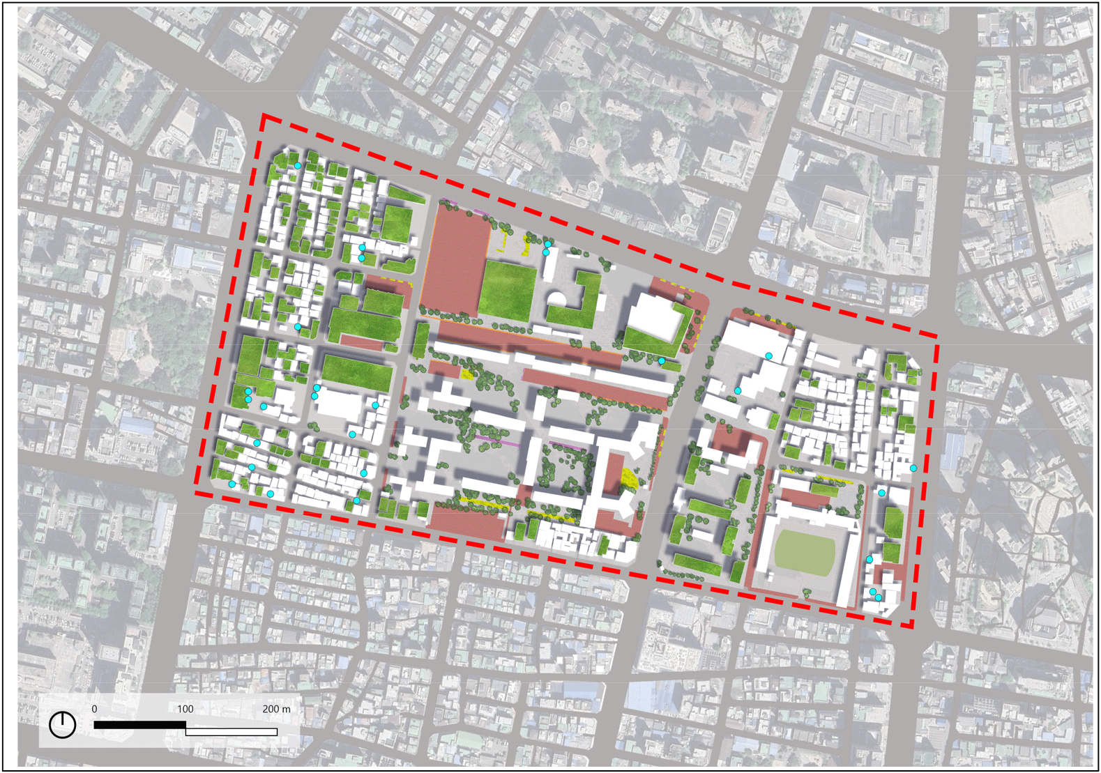
Yeongdeungpo-gu is located in the southern side of Seoul, adjacent to the Han River. This district is characterized by its flat terrain, unlike the mountainous area commonly found in the city. With a population of 374,794 within 24.52 square kilometer area, the district is notable for its dense urban environment that accommodates residential, commercial, and financial activities. To manage the complexity of the district, the study examines two specific blocks that represent the district’s typical urban environment (Figure 1). These include industrial zones and mixed residential and commercial areas complete with educational facilities. Moreover, the focus on two specific blocks allows for a comprehensive evaluation of the applicability and effectiveness of LID techniques in these representative areas, thus facilitating the potential extension of findings to comparable urban environments.
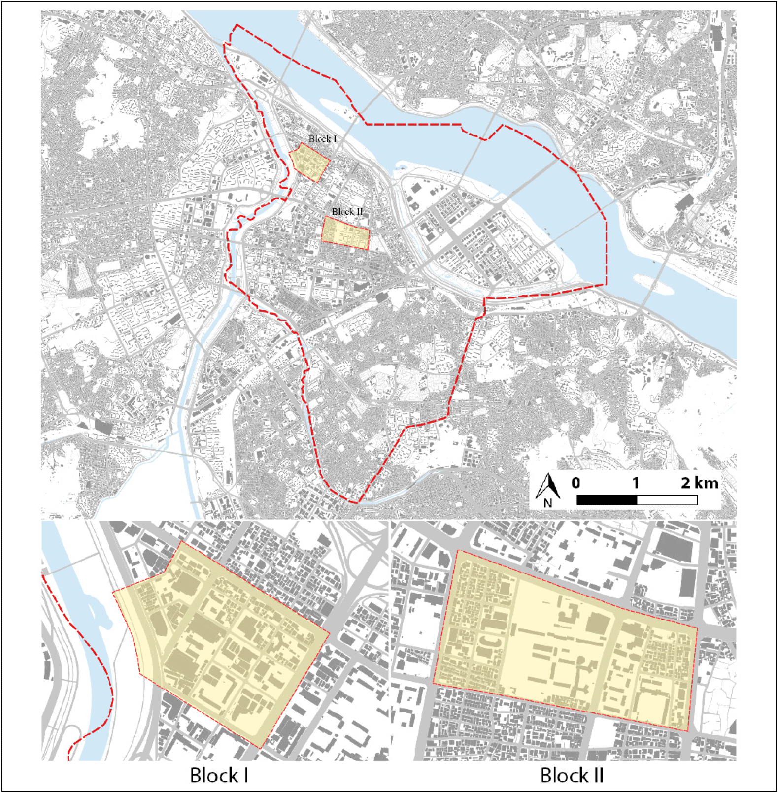
From the site visit conducted, each block selected shows different infrastructural and environmental characteristics that posed different challenges and opportunities for the LID implementation. The first block, an industrial area, characterized by wide arterial roads and vast structural manufacturing. There are big parking spaces and flat roofs building that contribute to a significant volume of runoff during storm events. The area is more open compared to another block, poses as a possibility in implementing the LID at some places such as pedestrian walkways, flat roofs, as well as the small parks.
The mixed residential and commercial block presented a contrasting urban environment in Block II. The presence of residential park creates some permeable zones for runoff. The existing green spaces create a potential LID implementation such as rain gardens to enhance site infiltration and reduce the stormwater volume. Additionally, there are some parts with wide pedestrian walkway and parking which has potential for further LID implemenation. However, the dense commercial area on this block poses a challenge in implementing the LID due to the tight and narrow lanes.
Digital Elevation Model (DEM), land use data, and existing drainage networks were utilized to develop a base map using QGIS, which served as the base map for Storm Water Management Model (SWMM) simulation. Precipitation data from the automated weather station (AWS) on August 8th, 2022, the day of a major previous flooding event, is used for the simulation. The rainfall began at moderate intensity of 0.9mm and reach a peak at 129.6 mm in the night of the flooding date. From the rainfall data, hourly and daily precipitation total recorded was 36.72 and 3,268.2mm, subsequently.
This study is divided into four main stages including information collection and model configuration, LID parameter selection, scenario modeling and simulation. The selection and design of LID parameters were guided by expert consultation and a review of existing literature and LID implementations in South Korea. The selected LIDs included green roofs, rain barrels, permeable pavements, infiltration trenches, vegetative swales, and rain gardens, categorized into building-based, open space-based, and combination scenarios.
The SWMM is utilized for simulating both with and without LID scenarios using surface runoff, peak runoff volume, and node flooding as parameters. SWMM is a notable tool in evaluating the effectiveness of LID applicatons at a watershed scale. Compared to other models, SWMM has gained wide acceptance for its efficacy in the planning, analysis, and design process concerning on the stormwater runoff and drainage systems (Uchiyama et al., 20022; Nazzari et al., 2023). SWMM has LID module with six kinds of LID technical contents which can represent LID facilities (Mogenfelt, 2017). The final analysis is compared the effectiveness of the various scenarios to mitigate urban flooding and identified the most effective LID techniques. This step included developing site plan, cross-section images, and perspectives to visualize the proposed LID practices.
The scope of this research is limited to assessing the effectiveness of LID practices for flood mitigation within two specific blocks in Yeongdeungpo-gu (industrial area and mixed residential-commercial area) due to its extensive complexity. These blocks were selected to represent typical urban environments within the district. Additionally, the reliance on historical rainfall data may not encapsulate future climate variations, and the modeling tools used have inherent limitations and may not fully capture all real-world variables influencing flood mitigation.
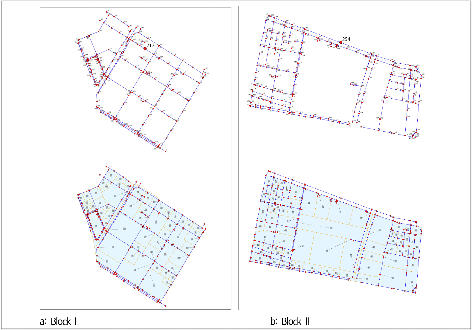
In this research, QGIS spatial data for conduits and nodes were sourced from the Seoul Metropolitan Government and subsequently adjusted for modeling simulations. The division of the study area into sub-catchments was determined by considering the boundaries of the pipe network, the road network, and the land use maps of the area. Block I, an industrial area, was divided into 57 sub-catchments, incorporating 226 conduits and 219 junctions. While Block II, a mixed residential and commercial zone, comprised 74 sub-catchments with 275 conduits and 261 junctions (Figure 2).
 Junction
  Conduit
  Sub-catchment
To accurately calculate the amount of rainfall, the number of losses, and the outflow from the sub-catchment,the physical parameters of the sub-catchment are introduced into the SWMM model (Table 1). These parameters and the methods for determining them are explained below. Hydrological models often divide a basin into sub-catchments to analyze partial changes and estimate runoff based on each sub-catchment's characteristics.
The study developed three Low-Impact Development (LID) scenarios in terms of their applicability: 1) the building level, 2) the open spaces, and 3) both combination of both, that are shown in Table 2. Scenario I propose the use of green roofs for building with flat roof and rain barrel for building with slope roof. The green roof implementation specifically targets new buildings due to their structural suitability. The applicable area for this scenario determined using QGIS is 81,941m2, which is approximately 16.23% of the total area for both blocks.
For the scenario II, the total usage area is 55,244m2. This scenario implements the use of permeable pavements, infiltration trenches, vegetative swales, and rain gardens. Permeable pavement is used for all wide walkways with widths over 3m and some parking lots within the sub-catchments. The width of infiltration trenches was set to 0.6m. Scenario III, the most extensive, combined both building-based and open space-based LID practices, covering a total area of 137,187m2 (39.82% of the total area). Each scenario is made based on site-specific conditions such as the availability of open space, existing infrastructure, and the type of urban development.
3. Results
Runoff volume refers to the amount of rainfall that does not infiltrate into the ground but flows directly into the drainage system from the entire sub-catchment area. Meanwhile, peak runoff volume is defined as the maximum volume of surface runoff occurring during the peak rainfall event. High peak runoff volume can overwhelm drainage systems and lead to flooding. The simulation results (Table 3) showed that Scenario 3 was the most effective in reducing surface runoff and peak runoff volumes in both blocks.
| Reduction rate (%) | Surface runoff | Peak runoff volume | ||
|---|---|---|---|---|
| Block I | Block II | Block I | Block II | |
| Scenario I | 13.2 | 7.1 | 0.04 | 0.1 |
| Scenario II | 12.0 | 12.9 | 7.37 | 9.3 |
| Scenario III | 24.8 | 19.9 | 7.49 | 12.6 |
In Block I, building-based implementation, resulted in 13.2% reduction in surface runoff. Scenario II, focusing on open space LID implementation, shows a lower reduction rate at 12%, while the combination of all LID practices showed the most significant reduction, with almost 25%. The analysis of peak runoff volume demonstrated significant differences between scenarios. During the simulation, the highest peak runoff volume before LID implementation was 6,955.74lps (liter per second). Using Scenario I, the peak runoff volume slightly decreased to 6,952.62, while with Scenario II, the result displays a significant reduction at approximately 7.4%. With the combination of both building and open space-based LID practices, the reduction rate is almost 7.5%.
In terms of Block II, the simulation results for Scenario I show a surface runoff reduction that is approximately 5% less than that of Scenario II. While Scenario 3 showed the most effective reduction, with 19.9% decrease of surface runoff. The analysis of peak runoff volumes for Block II demonstrates the same pattern as Block I. The highest peak runoff volume before LID implementation was recorded at 9,320.18lps. In Scenario 1, the peak runoff shows minimal decreased to 9,306.86lps, while Scenario 2 and 3 achieved notable reduction at 9.3% and 12.6%, respectively. This suggests that building-based LID measures alone may not be sufficient to significantly impact peak runoff volumes during high-intensity rainfall events.
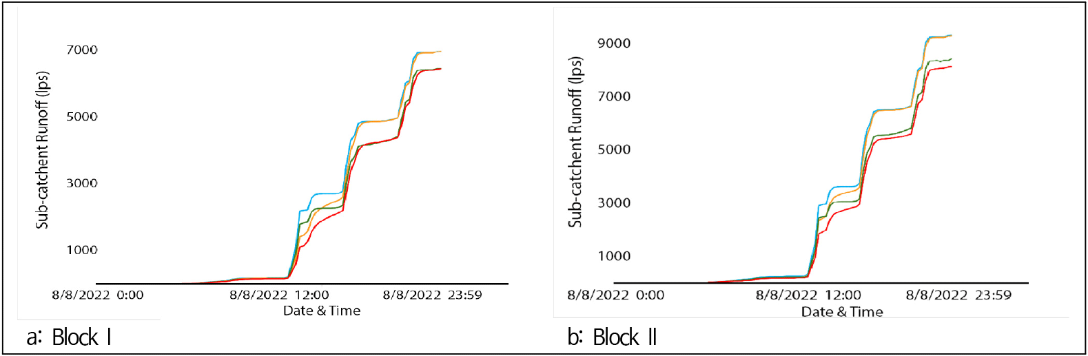
In addition to the runoff and peak runoff volumes, the temporal variation in runoff volumes for each LID scenario is depicted in Figure 3. For Block I, initially, all scenarios show a minor reduction in sub-catchment runoff. However, as precipitation intensifies, the combined LID scenario demonstrates the most significant decrease in runoff, followed by Scenario I and II. During the peak rainfall event, both Scenarios II and III show a notable decrease in runoff, indicating their effectiveness in managing high-intensity rainfall. The graph shows interesting data that Scenario 2 and the baseline (before LID) conditions exhibit lower total runoff immediately following the peak precipitation on the night of the simulation date.
 Before LID
  Scenario I
  Scenario II
  Scenario III
From the simulation of Block II, all scenarios show a reduction in sub-catchment runoff compared to the baseline. Before reaching the peak precipitation event, scenario I shows a significant reduction in runoff, highlighting the immediate effectiveness of building-based LID in capturing and delaying runoff at the source during the initial storm. Meanwhile, different patterns can be seen in Scenario II. This scenario shows a more gradual reduction in runoff initially, and remarkably outperforms building-based scenario during peak precipitation events. Since the early stage of simulation period, Scenario III remains the most effective method to reduce sub-catchment runoff compared to other scenarios.
Node flooding analysis showed that LID scenarios significantly reduced flood volumes at critical nodes in the drainage system (Table 4). In Block I, before LID implementation, node 217 experienced a flood volume of 2.7 million liters. Scenario 1 reduced this volume slightly to 2.6 million liters, while Scenario 2 achieved a more substantial reduction to 1.3 million liters. Scenario 3 further decreased the flood volume to 1.2 million liters, showing the highest effectiveness in mitigating node flooding.
| Total flood volume in node (lps) | ||
|---|---|---|
| Block I (Node 217) | Block II (Node 254) | |
| Before LID | 270 | 2,120 |
| Scenario I | 260 | 2,097 |
| Scenario II | 130 | 1,903 |
| Scenario III | 120 | 1,911 |
For Block II, node 254 had the highest flood volume of 21.2 million liters before LID implementation. Building-based scenario showed minimal impact, reducing the volume to 20.97 million liters. Scenario 2 and Scenario 3 were more effective, reducing flood volumes to 19.03 and 19.11 million liters, respectively. The variations in reduction rates across nodes suggest that open space LID measures, particularly those implemented in Scenario 2 and Scenario 3, offer better performance in flood mitigation compared to building-based measures alone. The results indicate the importance of integrating multiple LID strategies to address both immediate runoff capture and prolonged infiltration needs, highlighting the combined scenario’s superior efficacy in urban flood management.
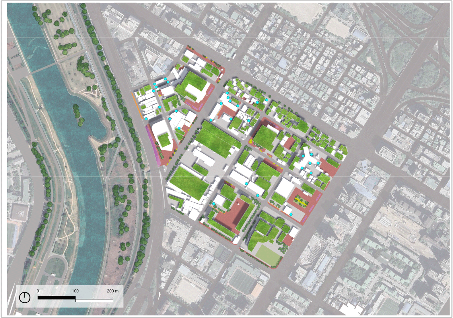
Given that scenario III demonstrated the highest effectiveness in reducing both runoff and peak runoff volume, the developed site plans illustrate the comprehensive implementation of this scenario. Scenario III integrates a combination of building-based and open space LID, optimizing the available area to maximize the benefit of each techniques. The site plan for Block I, as shown in the Figure 4, includes the extensive green roof installations on large, flat-roofed buildings to capture and delay stormwater runoff at the source. Permeable pavements are installed in parking area and pedestrian walkway. The plan also includes vegetative swales and infiltration trenches along open spaces and road verges, as well as rain gardens in residential parks and smaller garden space.
 Rain Barrel
  Green Roof
  Permeable Pavement
  Vegetative Swale
  Rain Garden
  Infiltration Trench
The site plan for Block II in Figure 5 illustrates the combined LID implementation within a denser developed urban area. Green roofs as the simplest LID technique, remain the most widely utilized in this block. Rain barrels are installed on buildings with sloped roofs, particularly in residential zones where space for larger LID practice is limited. Permeable pavements are integrated into the layout of major open areas and parking due to the narrow walkways on the site. Rain gardens are implemented into smaller green pockets within the block, while vegetative swales and infiltration trenches are strategically placed in available open space.
 Rain Barrel
  Green Roof
  Permeable Pavement
  Vegetative Swale
  Rain Garden
  Infiltration Trench
4. Conclusion
This research aimed to evaluate the effectiveness of Low-Impact Development (LID) strategies in mitigating urban flood risks in Yeongdeungpo-gu, Seoul. Through a comprehensive analysis of different LID scenarios, this study provides valuable insights into sustainable urban planning and flood management.
-
Significant Impact of Combined LID Strategies: Scenario 3 demonstrated the most significant impact on flood mitigation, indicating a linear relationship between the extent of LID application area and surface runoff mitigation. The combined effect can be attributed to the complementary functions of building-based and open space-based LID measures. Scenario I such as green roofs and rain barrels, primarily target the reduction of localized runoff by managing stormwater on individual buildings. In contrast, open space-based LID enhance the capacity for stormwater infiltration and dispersion over larger areas. The larger the area covered by LID practices, the more substantial the reduction in surface runoff.
-
Importance of open space-based LID: Despite Scenario 2 covering a smaller area than Scenario 1, it achieved greater effectiveness. This suggests that the use of diverse techniques in Scenario 2 contributed to its superior performance in reducing runoff and managing stormwater.
-
Interaction Effects of the Scenarios: The peak runoff volume in Block 2 showed interaction effects between the scenarios. While the simple sum of reductions from Scenario 1 and Scenario 2 was 9.4%, Scenario 3 achieved a reduction of 12.6%, indicating synergistic effects when combining building-based and open space-based LID measures.
-
Node Flooding Analysis: Scenario 2 had a more significant impact on node flooding compared to Scenario 1. This finding suggests that open space-based LID practices can have a greater effect on dispersing stormwater and reducing flooding at critical nodes within the drainage network.
While this study underscores the critical role of Low-Impact Development in urban flood management, several limitations must be considered. The research conducted on a local scale, focusing specifically on Yeongdeungpo-gu, Seoul. As such, the findings may not be directly applicable to other regions with different urban types, climate conditions, or hydrological characteristics. The scenario presented were based on current land use patterns and existing infrastructure, which may evolve over time. Nevertheless, consistent findings were obtained across two distinct urban blocks, suggesting that the effects of LID strategies could potentially be relevant to other other regions with similar urban characteristics. These findings provide realistic LID-based scenarios that could be valuable references for broader application in other regions.
As cities continue to grow and face increasing environmental challenges, sustainable strategies such as LID will be essential in shaping resilient and livable urban futures. The combined application of building-based and open space-based LID measures offers a robust solution to mitigate surface runoff and peak runoff volumes, thereby enhancing the resilience of urban areas to flood events. Although the result from this study provide valuable information on flood mitigation, future studies should explore more scalable methodologies to enhance the generalizability of LID strategies, This could involve testing the effectiveness of LID approaches in different urban environments, larger geographic areas, and more diverse climate conditions. Additionally, integrating LID strategies with other flood management approaches, such as smart water management systems, could provide a more comprehensive solution to mitigate urban flooding. Future studies should also aim to develop extensive methodologies that allow for a broader application of LID strategies beyond the localized context of the case study.