


I. Introduction
It is usual to see urban cemeteries in the United States that are right next to residential areas, which may speculate that cemeteries, namely spaces for the dead are not so different, in terms of locational patterns, from other urban facilities such as schools, markets, and government offices, that is to say, spaces for the living. However, this conjecture fundamentally brings up two important questions: 1) Were the cemeteries, for the first time, located in the city rather than outside the city? 2) Are the cemeteries actually located near residents? With these questions, this research aims to investigate spatial structure and historical change of urban cemeteries in Seattle. For this, I historically traced early cemeteries of Seattle, then objectively measured locational patterns of cemeteries, and finally identified how cemeteries in Seattle became urban facilities.
In this research, it is first required to clearly define cemeteries as a subject of study. J. S. Curl (2015) defined, in the Oxford Dictionary of Architecture, a cemetery as burial- ground, especially a large landscaped park or ground laid out expressively for the deposition/interment of the dead, not being a churchyard attached to a place worship”. Meanwhile, Rugg conducted an extensive literature review in order to define cemeteries and pointed out that cemeteries can best be understood through appreciating the nature of four interlinked features: Physical characteristics; Ownership and meaning; the site's relationship to personal and community identities; and sacredness (Rugg, 2000, p. 272) ”. In doing so, she compared and contrasted cemeteries with other similar facilities including church yards, burial grounds, mass graves, war cemeteries, and pantheons.
Further, cemeteries in the United States need to be understood in the historical context. According to Schuyler (1986), American rural cemeteries were evolved from European churchyard graves and newly emerged as a socio-historical product of the Western world. More specifically, Christians had buried their dead bodies in consecrated grounds adjacent to churches for centuries in the Western world. However, a new concern for the dead led to criticism of the church's burial practices and permanent grave sites. In 1765, the Parliament of Paris issued a decree closing all urban cemeteries and ordering the transfer of corpses to new burial grounds outside the city. In the first decade of the nineteenth century, Parisians established four municipal cemeteries in the city's outskirts: Montmartre, De Vaugirard, Montparnasse, and Père Lachaise, which later served as a model for American rural cemeteries. In the mean time, churchyard interments continued to be the custom in the United States until the 1830s (Stilgoe, 1982). In this historical context, this research could reveal the process of how rural cemeteries became urban cemeteries in the United States, focusing on the Seattle case.
II. Research Framework
Existing studies on cemeteries in the United States were largely divided into three research flows: First, cemeteries were classically studied as historical and cultural landscapes that had been evolved and transformed according to social changes such as urbanization, secularization, and commercialization (Warner, 1959; Sloane, 1991; Francis, 2003). Second, cemeteries were scientifically examined as a source of urban contamination threatening the environment and public health (World Health Organization, 1998; Oliveira et al., 2013). Third, cemeteries were practically explored as urban parks or green spaces for everyday use and community life (Harvey, 2006; Basmajian and Coutts, 2010; Harnik and Merolli, 2010). However, it was not fully discussed to look into urban-scale patterns of cemeteries in the city beyond case studies focusing on neighborhood-scale cemeteries (Keliehor, 1989; Seattle Genealogical Society, 1999; Beatty, 2002). Therefore, it would be meaningful to investigate spatial structure and historical change of urban cemeteries in Seattle, which could contribute to filling in the knowledge gap and providing insights on urban cemeteries.
Given the proximity of Seattle's cemeteries to urban residential areas, this research looked into the contextual relationship between cemeteries and the surroundings according to two time periods: the early formation period of cemeteries in Seattle and the current period. In addition, a mixed method was taken that combined historical analysis based on old references and historic maps with cluster analysis using GIS.
More specifically, the research historically analyzed how Seattle's early cemeteries responded to urban formation in the beginning of Seattle. For this, the research traced early cemeteries on historic maps, comparing and contrasting them with urban formation in Seattle. As a result, the research found out that early cemeteries of Seattle were tightly interrelated due to repeated relocation of corpses as Seattle grew. Especially, the research tried to answer the following questions:
How were early cemeteries of Seattle formed and evolved?
How closely related were early cemeteries of Seattle to urban formation in Seattle?
Next, the research objectively measured current pattern of cemeteries in Seattle through ArcGIS. For this, the research created locational maps of Seattle's cemeteries and shopping centers, calculated their average nearest neighbor indexes, and identified statically significant hot spots and cold spots of Seattle's population distribution using the Getis-Ord Gi* statistic. Especially, the research was conducted with the following detailed questions:
Is each pattern (cemeteries or shopping centers) random or clustered?
How different are spatial patterns of cemeteries and shopping centers?
What is the relationship between each pattern and population distribution pattern?
In the research, shopping centers, according to the definition of the International Council of Shopping Centers (ICSC), referred to a group of retail and other commercial establishments that is planned, developed, owned, and managed as a single property, typically with on-site parking provided” (ICSC, 2012). More specifically, the research dealt with the type of Community Center” among four types of shopping centers in Table 1, given that Seattle's cemeteries mostly ranges between 10 to 40 acres in area.
Source: ICSC, 2012
The reasons why the research looked into shopping centers as the comparison group of cemeteries are as follows: First, shopping centers are basically spaces for the living while cemeteries are spaces for the dead. Second, shopping centers are community and neighborhood facilities adjacent to urban residential areas, which are many, lively, and highly variable depending on economic conditions. Third, shopping centers are large enough to compare to cemeteries, as opposed to other community and neighborhood facilities such as education facilities (e.g. kindergartens, primary/secondary schools), governmental facilities (e.g. libraries, post offices, police/fire stations), health facilities (e.g. clinics, health centers), religious facilities (e.g. churches, temples), and recreation facilities (e.g. parks, playgrounds, sports centers).
III. Early Cemeteries of Seattle and Urban Formation
It is crucial to understand when Seattle was developed for the first time and how cemeteries were introduced to Seattle in order to conduct historical analysis of early cemeteries of Seattle and urban formation.
First, Seattle has relatively a short history of development and urbanization in the United States because it was located in the Pacific Northwest and far from the European colonies of North America in the 17th and 18th centuries (Chudacoff et al., 2010). It was not until the year of 1851 when the Denny Party as the first American settlers landed at Alki beach that the Seattle area in the Puget Sound started to be developed and urbanized. Before that, it was a long territory of Native Americans for at least 4,000 years (Newell, 1977; Thrush, 2007).
Native Americans had dealt with their dead bodies in a variety of ways before white people built the first cemetery in Seattle. Both cremation and ground burials were common. Cremation was often used when they died away from the tribe's home areas. Meanwhile, ground burials were most commonly used with trappings (Daly, 1984). For example, there were several burial grounds of Native Americans in downtown Seattle areas when the Denny Party arrived in Seattle. The best-known burial ground was on the bluff that used to be above the beach at what is now the foot of Seneca Street. Others were found further from downtown on the western slope of Beacon Hill and in Ballard just west of where the railroad bridge is, which was also on a hill (Daly, 1984). As the city grew, it is unknown whether any of the graves in these grounds were moved or not. However, it is probable that they were not because the bodies would have been incorporated into the earth and forgotten.
Second, Seattle as a late comer of urban development came to accept existing practices of cemeteries established in Europe and the United States. When Seattle was first developed, American rural cemeteries were already established as a type of facilities for the dead, which were evolved from European churchyard graves. In fact, it had been a long discussion on where people buried the dead, in the city or outside the city. The Romans buried the dead outside city limits, carefully separating the worlds of the living and the dead. The law of the Twelve Tables forbade interment in cities. However, churchyards were later main burial grounds for centuries in Europe, which were located in cities and towns (Schulyer, 1986).
In addition, there were people's growing recognitions in the United States towards American rural cemeteries: The disrepair of existing churchyards, the belief that urban cemeteries endangered public health, the insatiable demand for city land, and the acknowledgement of the psychological impact of scenery. In the meantime, Boston became the first American city to overcome the tradition of churchyard burials by appealing to the new attitude toward nature. In 1831, its citizens established a rural cemetery, Mount Auburn in neighboring Cambridge, which later played a significant role in the formation of other similar rural cemeteries such as Laurel Hill Cemetery of Philadelphia in 1836, Green-Wood Cemetery of New York in 1838 (Jackson and Horowitz, 1997). In the same context, Seattle came to follow American rural cemeteries as a type of facilities for the dead without many additional experiments because Seattle started to be developed from 1851.
As Seattle grew and people gathered in the city, cemeteries were naturally emerged and evolved. According to the extensive literature review on early cemeteries of Seattle, the first cemetery was emerged in downtown Seattle from 1853, which was two years later when the Denny Party arrived in Seattle for the first time. In addition, early cemeteries of Seattle from 1853 to 1887 were highly connected each other in the process of formation, removal, and relocation. In order words, as soon as they were formed, they were soon removed and relocated serially (Daly, 1984). As a result, certain graves surprisingly came to experience the four interments at that time. Thus, this research divided early cemeteries of Seattle into four periods according to the relocation as shown in Table 2, which revealed how early cemeteries of Seattle responded to then urban development pressure.
More specifically, the first cemetery of Seattle for the whites was the so-called Denny Hotel Cemetery at Second and Stewart or Second and Pine in 1853 according to the Post-Intelligencer's interview with Arthur Denny in 1898 (Daly, 1984). Aside from the cemetery, the Methodist Protestant or the first church in Seattle had the town's first formal graveyard on the southwest corner of Second and Columbia (Bass, 1974). There were also burials made on what was known as Maynard's point (Newell, 1977). Meanwhile, there were rumors of other cemeteries in different areas, but for the most part, these were turned out as one of the above was moved by faulty memory or wrong placement.
The second period's cemeteries such as Seattle Cemetery and Masonic Cemetery were formed by the need of rapidly growing town for larger cemeteries (Daly, 1984). Under the circumstances, David Denny (1832–1902) donated his five- acre land on Depot Street, which is now Denny Way, to the city for Seattle's first park. However, it was used as the Settle Cemetery from 1861 to 1884 with removed graves from older cemeteries. Later, it was transformed into Seattle Park, which is now Denny Park (Ferguson, 1995).
Meanwhile, Masonic Cemetery, which is now Lake View Cemetery, was platted on land belonging to Dr. Maynard in 1872, which was on the top of Capitol Hill. It was next to a pig farm and not at all easily accessible at that time. In spite of these problems, Masonic Cemetery sold lots on the not-yet cleared land in 1872. The cemetery proved successful, and had 237 graves by January of 1878 although many of them were removed graves from older cemeteries (Daly, 1984).
The third period's cemetery or Washelli Cemetery was the new municipal cemetery on top of Capitol Hill. It was one of the places where many of the bodies went when the graves were removed and relocated from the Seattle Cemetery. Originally, the place was a site where it would be used for the Washington State Capitol before the honor was won by Olympia, WA. As a result, in need of a cemetery, the city decided to use this property in 1884 as the municipal cemetery (Daly, 1984).
However, Washelli cemetery was later transformed into Volunteer Park in 1887 and its graves were relocated into Oak Lake Cemetery near the green lake built by David Denny (1832–1902) in 1884 in order to mourn for his dead son, which made the name changed into Evergreen-Washelli Cemetery, or the fourth period's cemetery (Shannon, 2007).
As pointed above, early cemeteries of Seattle were deeply related to then urban formation in Seattle. However, it was not clear whether early cemeteries of Seattle were by-products or precursors of urban formation in Seattle. Thus, the research examined this question in three different ways using historic census data, old maps, and the annexation history of Seattle.
First, the U.S. historic census data revealed how Seattle was formed and developed. According to the data, the period from 1880 to 1890 in Seattle was especially interesting given the fact that the population during the period increased more than 12 times as shown in Table 3, which is exactly the same as the period when early cemeteries of Seattle were most rapidly formed, removed and relocated. In addition, it suggests that its explosive population growth from 1880 to 1890 affected the urban formation significantly in the beginning of Seattle, probably in the downtown areas. In the same context, Thrush (2007) regarded the period ranging from 1880 to 1930 as urban revolution period, while he did the period before 1880 as village period. In other words, early cemeteries of Seattle were built ahead of the urban revolution in Seattle. Meanwhile, the population, area, and density were almost stationary since 1960 even though they had increased continuously. It implies that the city of Seattle was almost complete around the year of 1960 in terms of population change.
Source: Gibson, 1998, US Historica census data
Second, the research looked into old maps of Seattle as detailed visual references of Seattle's urban development history. Especially, three maps digitally archived at the Library of Congress were relevant to early cemeteries of Seattle. Using them, the research located early cemeteries of Seattle with their names and existence periods as shown in Figure 1. More specifically, the map of 1978 (Top) was connected to the first and second periods of early cemeteries discussed earlier, which showed that any urban development near cemeteries of Seattle Cemetery and Masonic Cemetery did not happen at that time. Next, the map of 1884 (Middle), related to the second and third periods, did not display certain urban development near cemeteries of Seattle Cemetery, Masonic Cemetery, and Washelli Cemetery. Finally, the map of 1891, connected to the third and fourth periods, described Mount Pleasant Cemetery and Lake View Cemetery vividly. However, specific urban development near the cemeteries was not expressed as well. In this sense, early cemeteries of Seattle were regarded to act as precursors of urban formation in Seattle.
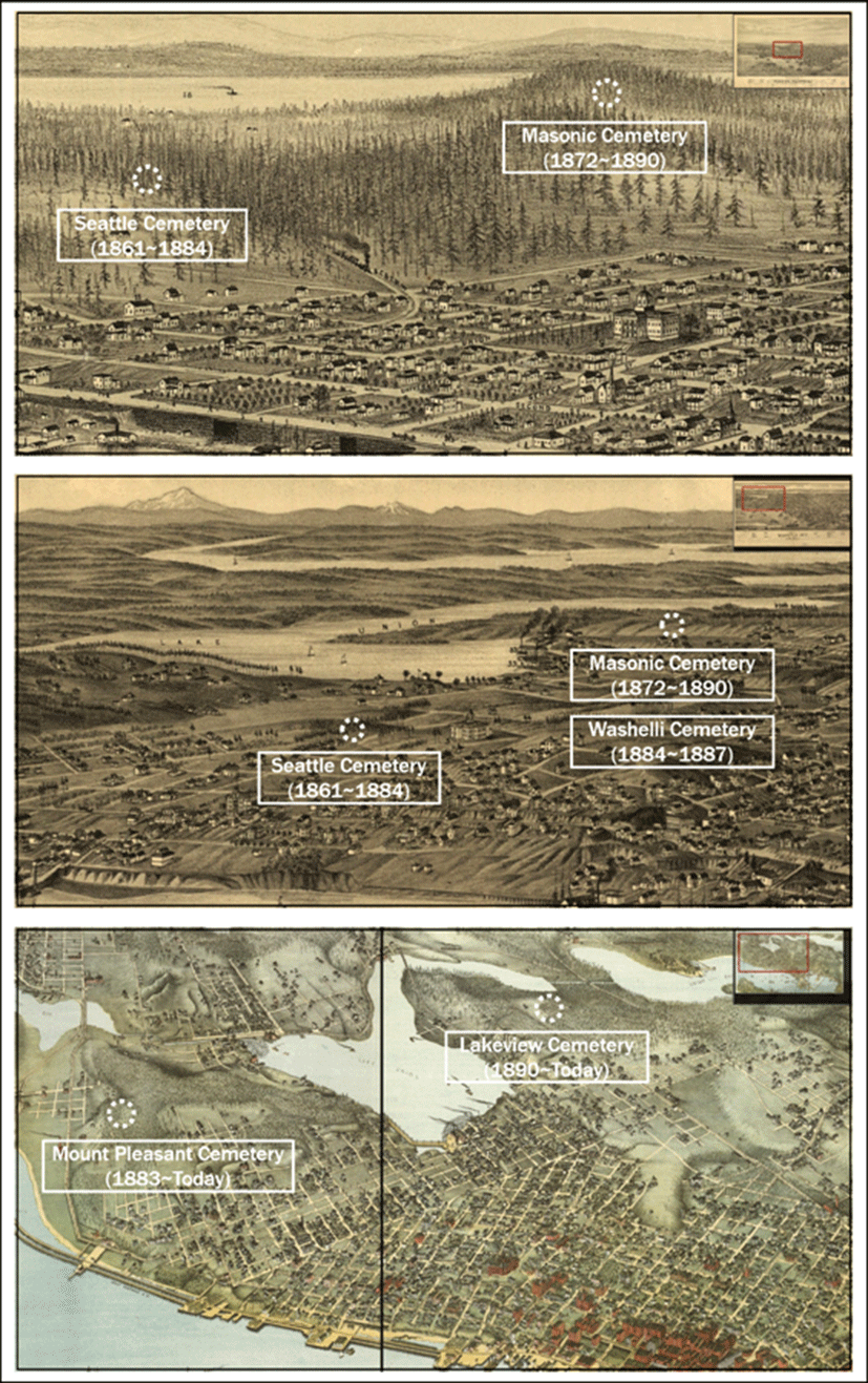
Source: Glover, 1878; Wellge, 1884; Koch, 1891, Geography and Map Division, Library of Congress
Third, the research examined the annexation history of Seattle as an indicator of urban formation. For this, the research created Figure 2 by locating early cemeteries of Seattle with their names and existence periods, on top of the map of original incorporation and annexations of the City of Seattle that was produced in 1938. This map displayed that early cemeteries of Seattle historically preceded the annexations of Seattle. For example, all areas nearby early cemeteries of Seattle were annexed into the City of Seattle after the cemeteries had been built. In other words, early cemeteries of Seattle in downtown areas were introduced as by-products of urban formation, but the cemeteries in the suburbs were established ahead of urban growth and neighborhood development. To sum up, early cemeteries of Seattle were originally located in rural areas. However, they later came to be located in urban areas, sustaining the landscape of American rural cemeteries.
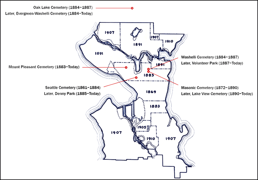
Source: Carle and Chase, 1938, Sanitary Survey Land Use Project, Seattle Municipal Archives
IV. Objective Measures of Cemeteries in Seattle
This research first acquired basic data including 2010 Census Tracts, Blocks, and Populations from King County GIS Data Portal. Then, additional data of cemeteries and shopping centers in Seattle were collected through Google Search and relevant literature. Meanwhile, the research's spatial boundary was restricted to the boundary of the City of Seattle that was an area between State Road 518 as the southern limit and 200th St as the northern limit. According to the research boundary, all data were clipped.
Second, all cemeteries and shopping centers were checked one by one on Google Map before geocoding their locations. Most cemeteries were large-scale urban facilities located near residential areas. Although most of the cemeteries ranged between 10 to 40 acres in area, several cemeteries highly exceeded the range. For example, Evergreen Washelli Cemetery reaches 144 acres, Abbey View Memorial Park covers 85 acres, and Holyrood Catholic Cemetery occupies 65 acres.
On the other hand, shopping centers usually included a group of stores and service establishments with large parking facilities and served as retail centers of neighborhoods. As specified above in 2.2 Research Method, sizes of cemeteries covered in this research fell under the type of Community Center”, according to the International Council of Shopping Centers (ICSC) ’s typology. As a result, the research identified 20 cemeteries and 46 shopping centers within the research boundary. All locations of selected cemeteries and shopping centers were geocoded on the base map according to the formal postal addresses by using ArcGIS Online Address Locator. The final dataset was summarized in Table 4.
Third, the research conducted cluster analysis by using ArcGIS Spatial Statistics tools in order to compare and contrast locational pattern of cemeteries with that of shopping centers. Especially, the research tried to answer the following three questions: Q1. Is each pattern (cemeteries or shopping centers) random or clustered? Q2. How different are spatial patterns of cemeteries and shopping centers? Q3. What is the relationship between each pattern and population distribution pattern?
The three research questions had different issues, which required different approaches and measures as shown in Table 5. More specifically, Q1 and Q2 were respectively answered with Average Nearest Neighbor (Q1), Mean Center and Directional Distribution (Q2), which were to measure locational patterns of cemeteries and shopping centers in terms of point distribution. Meanwhile, Q3 was explored with Hot Spot Analysis, which was to compare the above locational patterns with population distribution of Seattle in terms of similarity of distribution.
The index of Average Nearest Neighbor was measured in ArcGIS for this question. The index calculates a nearest neighbor index based on the average distance from each feature to its nearest neighboring feature. As a result, if the index is less than 1, the pattern exhibits clustering; If the index is greater than 1, the trend is toward dispersion. On the other hand, the Z-score value is a measure of statistical significance which tells whether or not to reject the null hypothesis (Ebdon, 1985). As shown in Table 6, the nearest neighbor ratio of cemeteries was 0.99 with a Z-score of -0.05, which meant that the null hypothesis cannot be rejected with a 95% confidence level. Meanwhile, that of shopping centers was 0.72 with a statistically significant Z-score of -3.67, which showed that the null hypothesis can be rejected with even a 99% confidence level. As a result, these two index values indicated that distribution of cemeteries was random, but shopping centers clustered. In other words, cemeteries were randomly dispersed across the seattle, but shopping centers were clustered statistically significant. It is thought that this difference resulted from the fact that shopping centers were much more clustered near downtown or local bases than cemeteries. In fact, about one fourth of shopping centers were located in the downtown of Seattle.
| Nearest neighbor ratio | Z-score | |
|---|---|---|
| Cemeteries | 0.99 | −0.05 |
| Shopping centers | 0.72 | −3.67 |
The indexes of Mean Center and Directional Distribution were calculated for this question and the relevant map was visualized using ArcGIS as shown in Figure 3. First of all, the Mean Center identifies the geographic center, or the center of concentration for a set of features. It is a point constructed from the average x and y values for the input feature centroids (Burt and Barber, 1996). On the other hand, Directional Distribution measures whether a distribution of features exhibits a directional trend (Wang et al., 2015). Meanwhile, the research took a one-standard deviational ellipse in containing locational points within each ellipse.
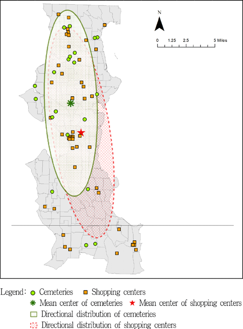
Source: Geocoded cemeteries and shopping centers
According to Figure 3, the Mean Center and Directional Distribution of cemeteries were located in the north of those of shopping centers. In addition, the ellipse of cemeteries was thinner and more vertical than that of shopping centers as identified in Table 7. They indicated that cemeteries were more clustered in the north of Seattle than shopping centers were. More specifically, locations of cemeteries were clustered in the north of Seattle while those of shopping centers were mostly scattered in the city of Seattle and partly clustered in the downtown of Seattle. Meanwhile, the value of rotation of long axis in Table 7 represents the rotation of the long axis measured clockwise from noon, which meant that cemeteries were more located in the north and south direction than shopping centers.
| Length of long axis (mile) | Length of short axis (mile) | Rotation of long axis (degree) | |
|---|---|---|---|
| Cemeteries | 16.15 | 4.59 | 174.26 |
| Shopping centers | 18.50 | 5.01 | 163.83 |
The index of hot spot analysis, namely Getis-Ord Gi* was calculated within the research boundary for this question. In addition, the relevant map was also visualized using ArcGIS. The Getis-Ord Gi* statistic identifies those clusters of points with values higher in magnitude than we might expect to find by random chance (Getis and Ord, 1992). The output of the Gi function is a Z-score for each feature. The Z-score represents the statistical significance of clustering for a specified distance. As a result, a high Z-score for a feature indicates its neighbors have high attitude values, and vice versa. The higher (or lower) the Z-score, the stronger the association. A Z-score near zero indicates no apparent concentration.
According to Figure 4, the Z-score of Getis-Ord Gi* showed a distinct pattern that had several obvious clusters marked in red or blue in the map. The hot spot analysis of population identified clusters of population with values higher or lower in magnitude. Interestingly, most locations of cemeteries and shopping centers were located in the hot spots marked in red, which meant that distributions of cemeteries and shopping centers were positively associated with population. Relatively, distribution of cemeteries was more positively associated with population than that of shopping centers. The exact numbers of cemeteries and shopping centers on the hot spots and cold spots of population distribution were clearly identified in Table 8.
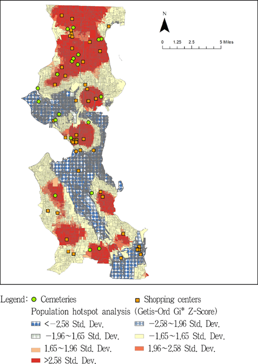
Source: Geocoded cemeteries and shopping centers, 2010 census tracks/ blocks/total population for King County
| Hot spots (>1.65 Std. Dev.) | Cold spots (<−1.65 Std. Dev.) | Total | |
|---|---|---|---|
| Cemeteries | 15 (75.0%) | 4 (20.0%) | 20 (100%) |
| Shopping centers | 32 (69.57%) | 11 (23.9%) | 46 (100%) |
V. Conclusion
This research investigated the spatial structure and historical change of urban cemeteries in Seattle. The research finally reached the following conclusions through the mixed method that combined historical analysis with cluster analysis.
First, early cemeteries in Seattle from 1853 to 1887 were highly associated with each other in terms of cemetery formation, removal, and relocation. They can be divided into four periods according to the relocation. During the process, David Denny (1832–1902) played a significant role in early cemeteries of Seattle. He donated his five-acre land on Depot Street to the city for the Seattle Cemetery and built Oak Lake Cemetery near the green lake in 1884.
Second, early cemeteries of Seattle in downtown areas were introduced as by-products of urban formation, but the cemeteries in the suburbs were established ahead of urban growth and neighborhood development. As a result, Seattle's cemeteries came to be located in urban areas that had been originally rural areas as Seattle grew and people gathered in the city. However they have been no longer removed and relocated since the early period.
Third, Seattle's cemeteries and shopping centers showed the following differences under the overall similarity in terms of locational patterns. Given the index of Average Nearest Neighbor, distribution of cemeteries was random, but shopping centers clustered. Meanwhile, the indexes of Mean Center and Directional Distribution indicated that locations of cemeteries were clustered in the north of Seattle while those of shopping centers were mostly scattered in the city of Seattle and partly clustered in the downtown of Seattle.
Fourth, most locations of cemeteries and shopping centers were located in the hot spots of Seattle's population distribution, which meant that distributions of cemeteries and shopping centers were positively associated with population distribution, Relatively, distribution of cemeteries was more positively associated with population distribution than that of shopping centers.
Finally, this research addressed comprehensive and deep understanding of urban patterns through historical reasoning and objective measurement to cultural landscape. If this research is expanded to compare many different cities in the world, it could draw a variety of spatial patterns for each country, each region, or each culture. They could show certain universality as well as distinct characteristics that cultural landscapes may have. This might be a chance to revisit existing cultural and religious analyses based on Feng-shui, Buddhism, or Christianity with new analytical methods of urban studies.
 “Original Incorporatiaion & Annexation, City of Seattle.” Sanitary Survey W.P.A. Project. City of Seattle: Seattle, WA. Available from the Seattle Municipal Archives at https://www.seattle.gov/Images/CityArchive/Exhibits/Annexations/Map.jpg)