


Ⅰ. Introduction
Recently, the importance of ecological value has been raised, and various studies have been conducted to preserve and restore ecosystems and promote biodiversity. Countries around the world designate and manage protected areas to promote conservation of biodiversity, natural resources, cultural resources, and ecological and cultural values. The United Nations Edu|cational, Scientific and Cultural Organization (UNESCO) has designated biosphere conservation zones to conserve natural ecosystems and genetic resources, and some national and public institutions have purchased land to preserve ecosystems in the protected areas.
The portions of land greatly affect water quality and need to recovery. The land acquisition has been done at the national level to improve water quality and preserve the environment in the surrounding watershed and protected areas. In case of South Korea, this kind of system is initially enacted in the “Agricultural Land Act” in December 22, 1994. The main statutes relevant to land acquisition are recorded in the special measures law, which dictates the designation and management of development restricted area, and forest protection law.
Korea Environment Institute (KEI) created the “land and environment evaluation map” for preserving, developing, and utilizing the homeland strategically and ecologically. The map is used to assess the environmental value based on the basic law of environmental policy. Evaluation indicators can be divided into statutory and ecological environment. The statutory indicator has 3 departments (natural environment, water environment, and others) and 56 indicators. The ecological environment indicator, reflecting the concept of natural resources, involves 8 departments (nature, diversity, richness, rarity, weakness, community structure stability, potential value, and connection) and 11 indicators.
The Korean Ministry of Environment (KME)(2007) classified the feasibility of specifying the environmental protection zone using four main parts: naturality, biological diversity, ecological system, and academic value in its objective research on the specified criteria for ecological protection zone. According to KME (2013), the list used for evaluating biotope type includes the naturality, biological diversity, rarity, scale, ability of restoration, ecological function and function of urban environment. Koo (2009) used the rapid assessment methods (RAM) and hydrogeomorphic evaluation methods (HGM) to assess the value of wetland conservation. In one of the previous studies on land evaluation of landscape ecology, Park (2014) developed an evaluation outline around the acquisition of land in protected areas.
According to a research on the evaluation criteria of land environment (KME, 2001), a suitable land that should be preserved is graded to propose a management principle and plan for each grade of land type. The value of land conservation can be divided into five grades: the first and second grades are areas of conservation, the third and fourth grades are areas of management, and the fifth grade is the development area.
According to the literature review on the purchase and use of domestic and foreign land, and the guidelines for buying land business provided by the land acquisition system, land acquisition mainly targets the ecologically important areas, such as water source protection areas, waterfront areas, and protected areas, and aims to eliminate pollution sources, improve water quality, and conserve and restore the ecosystems. Priority selection is implemented based on the location characteristic of each land. In general, the detailed criteria are set according to usage areas, such as factories and barns, and restricted areas, such as protected and waterfront areas. In the case of a waterfront area, the score table is calculated based on the distance from the river boundary. In addition, if a point or non-point source is adjacent to the purchased land, then additional points are given, which indicate the characteristics of the current buying process. Existing purchased land is sporadically distributed as a result of purchases by local residents, resulting in administrative problems. In addition, the criteria for the comprehensive standard of distance or pollutant allocation at the purchase stage do not fully reflect the essential unit ecology and spatial ecological connectivity of the land. Therefore, this study aims to solve the practical problems of land acquisition and develop an acquisition system to export systematic priority selection through an ecological evaluation. The land purchase system of this study was developed by integrating the parcel evaluation of the land and the spatial evaluation of the zone based on the ecological evaluation. It is expected that this ecological evaluation method and land purchase system will be useful for restoration of purchased land and establishment of ecological management in the future.
Ⅱ. Data and Methods
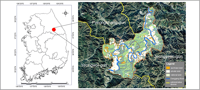
Among the ecological landscape conservation areas, the Donggang Basin is selected as the study area because of its vast preserved area of natural environment. This watershed has a larger number of lands to purchase than other watersheds, and the distribution types are diverse, making it suitable for analysis by separating into forest type, cultivation type, facility type, and wetland type. This area is located at a longitude of 128°29'–128°40' and latitude of 37°12'–37°22', which includes Yeongwol-gun, Pyeongchang-gun, and Jeongseon-gun (Refer to Figure 1). It’s not only the ecological landscape conservation area of the Donggang Basin that reflect all kinds of land acquisition, such as terrestrial ecosystem and settlement (or urban) ecosystems, but also the aquatic ecosystem is selected. The land acquisition includes a total of 1,470 parcels that corresponds to 7,242,547m2 in which the 4,492 (31,580,338m2) and 1,602 (70,875,051m2) parcels belong to private and national lands, respectively. A total of 1,470 parcels were purchased until August 2014, with which the field survey is implemented to all these locations(Li, 2015). Four types of lands were categorized according to the land cover and land use: forest, cultivation, facility, and wetlands.
Evaluation system is divided into ecological evaluation of parcel-based and zone-based. The comprehensive grade of ecological evaluation is established according to the comprehensive evaluation criteria.
The ecosystem has a variety of functions including wildlife habitat, plant habitat, water purification, underground water storage and filling, and recreational sites, and is also valuable in response to climate change. Research on evaluation criteria for protected areas began in the late 1960s and there have been studies to identify evaluation factors from the early 1970s (Ra et al., 2001). Most of the studies on the designation factors and criteria of the protected area were based on the evaluation items proposed by Ratcliff. This study select seven items (sources of point and non-point pollution, vegetation diversity, landscape diversity, exotic plants, view on waterside and road, connectivity, and possibilities of wildlife habitats) based on the previous evaluation items and models of ecological protection areas proposed by the Ministry of Environment (KME, 2007), the Ministry of Environment (KME, 2007), and Park (2014), which provides better accessibility for an on-site inspection(Refer to Table 1). The seven evaluation items were finally selected as the most suitable and easy to evaluate items for the Donggang basin. (Li, 2015).
| Evaluation items | Criteria | Reference literature |
|---|---|---|
| Point and non-point pollutions | High: none / Middle: 1to2 / Low: three or more | Park(2014) |
| Vegetation diversity | High: more than 60 species/ha / Middle: 31-69 species/ha / Low: less than 30 species/ha | Ra et al. (2001), Adamus and Clough (1978), Freeman (1999) |
| Landscape diversity | High: more than 5 patches / Middle: 3-5 patches / Low: less than 3 patches | DDI (2013) |
| Exotic plants | High: No invasive alien species and dangerous plants / Middle: 1-2 species of invasive alien species or advantages of dangerous plants and vines / Low: 3 or more species of invasive alien species or advantages of dangerous plants and vines | Kang (2008), SMG (2005), SDI (2010) |
| View on waterside and road | High: complete opening / Middle: a little opening / Low: closed | Landscape guideline of urban regeneration project of Korea |
| Connectivity | High: less than 150m / Middle: 150m-1km / Low: more than 1km | Tilton et al. (2001) |
| Possibilities of wildlife habitats | High: 3 or more forest and wetland / Middle: 1 to 2 forest and wetland / Low: no forest and wetland | Kim (2012) |
Several evaluation methods are used to set the conservation grade: 1) emergency management accreditation program (EMAP) evaluation system introduced by the Environmental Protection Agency of the United States; 2) pressure–state–response (PSR) evaluation system by OECD (1993); and 3) driving force–PSR evaluation system by OECD (2004). Among them, KEI used the PSR evaluation system to develop the evaluating indicators. As such, there are many cases in which an ecological evaluation is graded on a five-point scale or three-point scale. The evaluation grade provides a three-scale of general ecological evaluation grade based on previous research, such as UNESCO MAB, biotope type evaluation (Kim, 2012; Cheonan City, 2008), the water ecological health evaluation grade (KME, 2008), the evaluation level of ecological preservation management(Kang, 2008.) and Seoul Metropolitan city(SMG, 2005) wetland evaluation system. Three points are given to the condition of high- ecological value, two to the middle, and one to the low- ecological value. Ecological evaluation is implemented by summarizing the aggregate score of evaluation items and the evaluation results of each item applied to the Koo (2009).
Zone evaluation is implemented using the distance standard of key ecosystem and national environment evaluation in order to establish ecological network and enhance biodiversity of the ecological landscape conservation areas. According to the standard of the ministry of environment, the river, lake, and first-grade areas in the ecological zoning map are selected as a key ecosystem, and the distance standard considers moving the distance of small and medium animals. According to the ecological channel settings and management guidelines (KME, 2010), the eco bridge of wildlife is specified to more than 30m (or 100m). The national environmental evaluation is a process that evaluates the physical and environmental value of a land to improve its health and comfort of land ecology (and environment) through a sustainable preservation of environmental resources. Moreover, this evaluation is a process that determines the ecological value of a land and assesses the development induced by the environmental impact to a specific land.
The distance standard evaluation of key ecosystem evaluates the land acquisition located in the inner 30 m from the key ecosystem to the top class of ecological function due to its high ecological value; thus, the acquisition buffer zone from 30m to 100m is assessed as a middle class, and acquisition buffer zone farther than 100 m is defined as the transition area assessed as a low class. In Korea, the national ecological evaluation assesses various environmental factors of territory and classifies five grades based on the ecological value. In this study, the first and second grades refer to the top class, the third and fourth grades refer to the middle class, and the fifth grade refers to the low class of the ecological evaluation.
In this study, the ecological evaluation is implemented to establish the efficient use and management system of land acquisition. The overall rating is graded in the direction of low ecological evaluation rating to characterize the priority of land acquisition and restoration, and management plan setting(Refer to Table 2). The reason for rating the ecological evaluation grade in the lower direction is to improve the ecology of the land as much as possible by restoring the priority of the low ecological grade in the case of future ecological restoration.
This study conducted literature surveys and expert questionnaires to develop an ecological evaluation model for each parcel. The evaluation model derived items and criteria that can be evaluated in the field, and a questionnaire survey is conducted among 30 experts for weight analysis. We refer to the previous research on ecological land evaluation methods to develop a reliable evaluation model (Park, 2014). For the analysis, we use Analytic Hierarchy Process (AHP) technique to estimate the weight of the evaluation items. The AHP technique is an evaluation technique that is commonly used in weight analysis of evaluation items, and it can derive relatively objective ecological evaluation results by sufficiently reflecting the importance of each evaluation item through expert surveys.
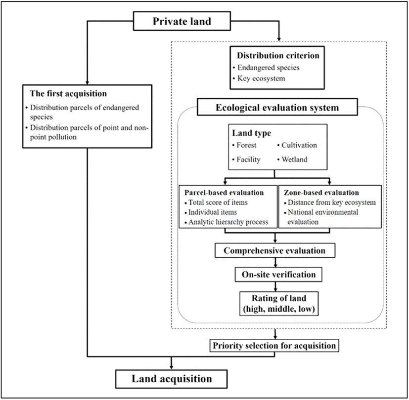
In this study, the items for the acquisition system were set up based on the literature on land purchase and use, and the guidelines for the land purchase. Consequently, the distribution area of endangered species or point and nonpoint was selected as the first, and then the priority was placed on the site where the ecological rating of the private land. Developed land acquisition evaluation system mainly involves 1) ecological and comprehensive evaluation based on land type, 2) final review by performing a feedback process through an on-site verification, and 3) establish GIS DB by completing the grade setting for each land type. The overall land purchase process is shown in Figure 2.
Ⅲ. Results and discussion
As a result of ecological evaluation for whole parcels (Refer to Table 3), the average score of connectivity is the highest at 0.455, followed by 0.379 at point and non-point source, 0.359 at wildlife habitability, 0.357 at vegetation diversity, 0.301 at landscape diversity, 0.256 for exotic plants, and 0.187 for viewing from the waterside or road. In terms of acquisition type, the average score of forest type is the highest with 0.373 points, and the facility type is the lowest with 0.303. The high score in the forest type is the inaccessibility and relatively less human interference in a well-preserved forest.
As an evaluation result of an individual item by parcels, a total of 225 parcels have high-ecological function, 418 parcels have middle, and 55 parcels have low-ecological function. No parcel is evaluated in the forest and wetland types with low-level ecological functions, which can be illustrated as well as managed in these areas.
According to the overall rating result by zones (Refer to Table 4), 174 parcels are evaluated to have the high-level ecological function, 399 parcels are evaluated to have the middle level, and 112 parcels are evaluated to have the low level. In terms of type, most parcels of forest are evaluated to have high and middle levels; whereas most parcels (448 parcels in total) of cultivation type are classified into middle and low levels and should therefore be prioritized for restoration in the future. In addition, waste building and waste materials are considered to be the factors of landscape degradation in the ecological aspect of the facility and wetland types. Hence, priority restoration is necessary. Another 772 parcels are areas where accessibility is difficult or impossible, and other measures are needed to be developed for the area when establishing ecological restoration and management plans.
According to distance assessments from key ecosystems (zone-based evaluation), the number of the parcels located within 30m (high-ecological function) is 231; whereas the parcels located within 30-100m (middle level) are 129, and those located >100m (low level) are 338. As results of national land environmental evaluation by zones, 424 (occupying 61%), 208, and 66 parcels are evaluated to have high, middle, and low level of ecological function, respectively. In the case of comprehensive rating evaluation by zones, 202, 270, and 226 parcels are evaluated to have high, middle, and low level of ecological function, respectively. In general, the ecological rating by zone is similar, which indicates a widespread distribution of land acquisition in ecological landscape preservation areas. In terms of type, 168 parcels of farmland are evaluated to have high-ecological function, which occupies 7% of the total land acquisition.
As a result of the ecological comprehensive evaluation to land acquisition in the ecological landscape area of the Donggang Basin, 50 parcels are evaluated to have a high level of ecological function; whereas 440 parcels are classified into middle level, and 208 parcels have a low level (Refer to Table 5). The overall rating shows distinct differences compared to ecological function evaluation by parcels (or by zones). Areas with a high-ecological function decrease by more than half in the comprehensive evaluation result due to the final evaluation implemented in the direction of low-ecological function, thereby lowering the overall grade.
A total of 28 of 30 valid samples are extracted from the questionnaire survey, from which we obtain a reliable consistency index (CI) value, which is less than 0.1 after implementing the weight analysis (Refer to Table 6). As a result, the weight of vegetation diversity is the highest at 0.191 among evaluation items, whereas the view on waterside (or road) is the lowest at 0.078.
A total of 180 parcels are included in the land acquisition in Gasu-ri, which is a region in Jeongseon-gun. Among these parcels, 92 are classified as separate management areas due to inaccessibility or restoration. Separate management areas are areas where human interference is low or artificial development is difficult. These areas are maintained with minimum management. On-site verification is performed for the other 88 parcels. The 75 parcels conform with one another, which represent more than the 85.2% consistency compared to the result of the evaluation.
On-site verification, which represents more than 85.2%, shows comparatively high. The 12 of 13 parcels are inconsistently evaluated in the type of cultivation, which is probably due to the difference in time. The ecological evaluation occurred mainly in autumn (from July to September), whereas the on-site verification is executed in November. In other words, evaluation is highly inconsistent because the seasonal vegetation growth and crop planting are actively performed during the ecological evaluation period; however, the vegetation has withered or the crops are harvested during the period of on-site verification. Therefore, the overall evaluation system is considered valid and reasonable.
The ecological evaluation method and purchase system developed in this study were applied to the study area and were shown in Figure 3.
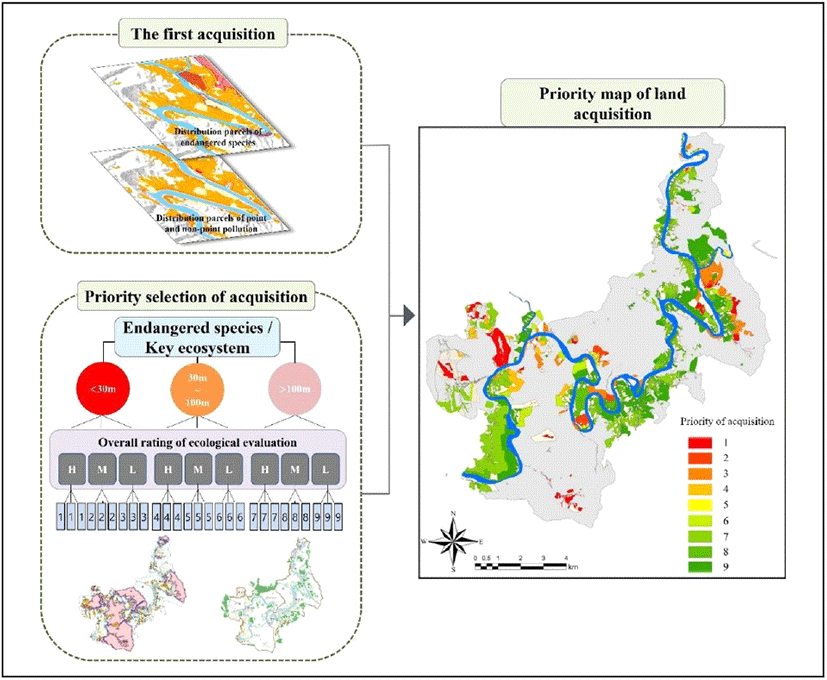
To verify the results of the study, the acquisition system is applied to some private sites in the ecological landscape conservation area of Donggang Basin. The field survey and ecological evaluation are conducted for 68 parcels with a good accessibility to show the characteristics of private land throughout the Donggang Basin. The evaluation results were set from 1st to 9th as shown in Table 7, and the top five grades are selected to complete the priority of acquisition based on the location characteristics of the private land. Based on the calculation of purchase priorities for some of the private land, the purchase was ranked fifth, but each site accurately reflected the ecological characteristics and the introduction of a system for ecological restoration and ongoing management. This proves that the acquisition system developed in this study is relatively systematic.
As described above, the ecological evaluation method and the purchase system developed in this study can be applied not only to the prioritization of land purchase in protected areas, but also to be useful in establishing strategies for restoring and managing purchase land. For example, it is possible to set the priority of the purchase land restoration according to the endangered species distribution standard, the core ecological distance standard, and the ecological evaluation grade, and establish short-term, medium-term, long-term restoration and management measures accordingly. It can be set as a short-term, medium-term, or long-term restoration area according to the ecological evaluation grade. As for the management plan, the ecological evaluation grade “Priority" establishes an adaptive management plan with the goal of restoring ecological resources and biodiversity, secures a biological habitat and induces and monitors vegetation natural transition; “Middle" induces an adaptive management method with the goal of improving ecological functions; and “Bottom" aims to enhance the maintenance of facilities and surroundings by restoring it to a hydrophilic complex with the goal of ecological use.
However, this study develops an acquisition system based on ecological evaluation and do not consider other aspects, such as economic benefits, which should be considered and be added as factors of acquisition. For instance, the geographical location, which is a significant factor for determining the economic and ecological environmental growth of valuable species, should be considered. Conversely, further study on the establishment of management system is necessary for sustainable preservation; because the value of land may depreciate, for example, due to the invasive species and pollutions without the appropriate strategy for continuous monitoring and management. The worse scenario may arise considering the issue of discontented neighbors to defend their living environment.
Ⅳ. Conclusions
Land acquisition is implemented to improve the water quality and preserve the environment of the surrounding watershed and protection areas. To some extent, land acquisition is mainly implemented through an agreement with the landowner; however, a systematic land acquisition is needed for sustainable preservation of the conservation and protected areas. Regarding this issue, this study develops a land acquisition system based on the ecological evaluation. In this study, a systematic and efficient land purchase system was established by developing an evaluation system by integrating parcel evaluation and zonal evaluation. The system was applied to the Donggang basin to prove its feasibility through on-site verification, and it compensated for various problems in the existing land purchase process.
This study does not consider aspects, such as economic benefits and strategy of management in the system of land acquisition. Although these aspects are important to establish a better system for achieving sustainable preservation, this study is significant due to the developed acquisition system, which utilizes an evaluation system considering the distribution of variance and ecological connectivity. Furthermore, the efficient ecological evaluation method and the basic guidelines of acquisition system are provided in this study, which are expected to be used as a fundamental material for further detailed study on acquisition system.