


Ⅰ. Introduction
The paradigm of the freeway has changed, from a path that connects us to a barrier that separates us.1) Although mobility, labor input, and manufacturing output are enhanced (Cervero, 2009), urban freeways also create problems such as air and noise pollution, damage to scenery, and environmental costs (Clay and Smidt, 2004). Many freeways built from the 1930s to the 1960s have also reached the end of their lifespans and need structural maintenance (Ebeling and Rhodes-Conway, 2013). Urban freeways have thus become a major topic in urban planning, whether for their removal, repair, or redevelopment. The redevelopment of freeways into urban parks is a growing trend around the world,2) and it now includes not just freeways but other transportation infrastructures such as railways and elevated roads.
Another paradigm in recent is the big data recently emerged as a new data source for urban studies. Big data is a phrase indicating a significant change in data collection, storage and analysis. Provost and Fawcett (2013) define big data as data sets that are too large for traditional data-processing systems and that therefore require new technologies. According to Zikopoulos et al. (2013), big data have four dimensions: (1) volume, (2) velocity, (3) variety and (4) veracity (Zikopoulos et al., 2013). One of the unique characteristics of this data is every one of us generates very large amounts of data each day and we call this, user-generated data. Millions of people use social media services such as Twitter, Instagram and Snapchat, to update with others and record their thoughts and locations (Tasse and Hong, 2017). This kind of social media data will let urban planners, policy makers and landscape architects understand how people have the relationships within a city.
A lack of information on this new type of park-the linear park-and big data-social media-could lead to designers and planners failing to serve the interests of potential visitors. Park features such as size, facilities, and vegetation have changed often according to social context. At the beginning of the nineteenth century, parks were represented as pleasure gardens that brought natural landscape features into the city (Hayward, 1989). Later, physical activities emerged as their main feature (Cranz, 1978), and parks were valuable for reducing health problems such as obesity and diabetes. To create a park that meets people’s needs, designers and planners must understand which uses to encourage through behavior-based design (Kaplan, 1980; Whyte, 1980). However, not all recent parks have met the needs of the public, which means that traditional methods are not adequate to identify some hidden needs.
This quantitative study compares linear parks in two countries on the basis of the landscape perception model, by using visitor surveys to identify linear park users’ characteristics for future design and planning purposes. The study is guided by three research questions: (1) What are the unique characteristic of the linear park? (2) How do people use the park? (3) What outcomes can users get from the park?
Ⅱ. Literature Review
This section explains two main factors in this study, people’s behaviors and their perceptions, on the basis of landscape perception models. These models have been developed and used for a long time in landscape architecture (Zube et al., 1982) especially in studies of the forested places (Anderson, 1981). In this section, landscape perception models are introduced first. Then people’s behaviors are described using two variables: motivations and activities. Lastly, people’s perceptions of parks are described using two variables: benefits and satisfaction. By reviewing previous literature, this section helps readers understand these variables were chosen for this study.
In the 1960s, the need to identify and manage scenic resources increased following mass development projects such as highways (Laughlin and Garcia, 1986). Zube and his colleagues developed a model of landscape perception to use as a research framework for reviewing the literature in 1982. To consider the interactions between humans and the landscape (Zube et al., 1975), they used three components: the human, the landscape, and the outcomes (Refer to Figure 1). The “human” in this case refers to the social and cultural attributes of individuals and groups, particularly in their interactions with the landscape. The “landscape” in this model refers to tangible elements or relationships in the landscape. The last element, outcomes, includes all the products that emerge from the interaction between the human and the landscape (Zube et al., 1982). In this section, landscape perception theories and related methods are reviewed to explain how people interact with and within a place.
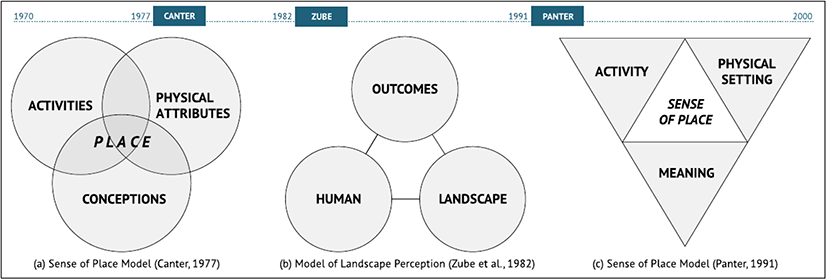
Understanding people’s perceptions and preferences was important for protecting scenic areas in the 1960s (Anderson, 1981; Zube et al., 1975). So, landscape architects actively developed a model to assess their value. According to Zube et al., (1982), there are four general paradigms of landscape perception research: (1) the expert paradigm, (2) the psychophysical paradigm, (3) the cognitive paradigm, and (4) the experiential paradigm. And Daniel and Vining (1983) divided the assessment tools into four categories: (1) formal aesthetic models, (2) psychophysical models, (3) psychological models, and (4) ecological models.
In this study, the author describes the landscape assessment tools based on Daniel and Vining (1983)’s study. The authors also use the three components of landscape perception models, human (activities), landscape (physical features), and outcomes (benefits), to understand what elevated parks are, how people use them, and what benefits they perceive in them.
Connectivity has been considered a substantial feature of linear parks such as greenways, trails, and green corridors (Shafer et al., 2000). Connectivity is also the main characteristic of elevated parks. In this classification system, connectivity includes both general connectivity and accessibility. As the main feature of elevated parks, connectivity is important for promoting social interaction (Maddox, 2016), biodiversity (Bunce et al., 2013; Shin et al., 2011), and recreational opportunities (Mertes and Hall, 1995; Moore and Ross, 1998). Some researchers consider accessibility separately, but because it includes points of access for connecting places (Shafer et al., 2000), it is considered part of connectivity in this study. Overall, connectivity involves where an elevated park is located and how well it connects nearby places. According to Shafer et al., (2000), “The connectivity greenways provide is important to human and non-human life.” In human terms, a linear green space connects people to their final destinations, such as schools, workplaces, coffee shops, and banks. Because of the importance of connectivity, the Transportation Equity Act for the 21st Century funded transportation-based trails (Shafer et al., 2000). Kaplan, Kaplan, and Ryan investigated how human experiences in linear green spaces allow them to feel mystery and exploration (Kaplan et al., 1998). On the basis of empirical evidence, Shafer et al. claimed that connectivity is an essential feature of linear green spaces.
Understanding the sociodemographic characteristics of users is important for landscape architects and planners to provide appropriate places to promote various uses of parks. There are two approaches to the design and planning of open spaces. One considers the demands of the population and provides open spaces for recreation, amenities, and education. Most green spaces, such as parks, urban forests, and greenways, are provided in response to such demands (French, 1973; Heckscher and Robinson, 1977; Maruani and Amit-Cohen, 2007; Turner, 1983; 1992), and the demand approach has been used by planners, geographers, and landscape architects. The other approach considers an open space as a means for conservation of natural resources (Maruani and Amit-Cohen, 2007; Safriel et al., 1997). This approach, called the supply approach, has been used in ecology and sometimes in landscape architecture.
In the demand approach, understanding user characteristics is a way to fulfill the population’s desires when making a place. To design and plan an open space in a certain area, it is important to understand the attributes of the target population (Maruani and Amit-Cohen, 2007). Many studies have identified relationships between demographic characteristics and park uses, preferences, activities (Gobster, 2005; Kaczynski et al., 2008; McCormack et al., 2010; Wang et al., 2015; Wright Wendel et al., 2012). But other variables such as distance (accessibility), motivation, and benefits are also important for providing open spaces.
The aim of this section is to understand user characteristics in terms of demographic characteristics that affect to park uses, such as age group, gender, ethnic group, education level, and income level. By reviewing the literature on the relationship between sociodemographic characteristics and park usage, we can derive implications for designers and planners.
Many studies have been conducted on the benefits of urban parks to determine their functions and roles in cities. These benefits can be divided into several categories. Some studies have divided them into direct and indirect benefits (Akbari et al., 2001; Tempesta, 2015); others into on-site and off-site benefits, depending on the causes of the benefits (Lockwood and Tracy, 1995; More et al., 1988), and many more into three types: economic, social, and environmental benefits (Stringer et al., 2006; Wolch et al., 2014). Moore and Driver (2005) went further and used five categories: (1) personal psychological, (2) personal psychophysiological, (3) social and cultural, (4) environmental, and (5) economic benefits (Moore and Driver, 2005). Personal psychological benefits include benefits to mental health, personal development, and personal satisfaction. Personal psychophysiological benefits include benefits from physical activities such as fitness, weight loss, and improved quality of life. Social and cultural benefits include community satisfaction, bonding with family and friends, and crime reduction. Environmental benefits include preservation of heritage, development of an environmental ethic, and learning from nature. Economic benefits include increased property value and reduced health costs (Moore and Driver 2005). This study focuses on the benefits of park experiences in terms of users, and thus this review focuses on four main benefits of parks: economic, social, personal, and environmental.
Many studies have examined the role of urban parks in improving the quality of daily life in an urbanized society. Empirical evidence supports the idea that urban parks, greenways, and urban forests improve quality of life in many ways. In addition to environmental benefits, such as reduction of pollution, urban parks help improve health and social interaction and provide peacefulness (Barbosa et al., 2007; Chiesura, 2004; Ulrich, 1981; Ulrich et al., 1991). Ulrich (1981), for example, compared psychophysiological reactions to three landscapes, vegetation, water, and urban, using metrics of physiological and psychological traits, and found that vegetation and water landscapes had more beneficial influences on people’s psychology. Chiesura (2004) reported that urban parks provide social and psychological benefits and enrich people’s lives with meaning and emotions. She verifies that the experience of nature is a source of positive feelings by investigating how people’s emotions are affected by urban green spaces. Coley et al., (1997) verified that urban parks encourage social interaction among residents and contribute to social integration. Their findings suggest that natural elements increase opportunities for social interaction by using outdoor places to promote communication within neighborhoods (Coley et al., 1997).
Natural environments can also help people relax and promote social interaction (Kuo et al., 1998). Kou et al. (1998) showed that the presence of nature in the inner city generated positive responses from residents. The density of urban nature also increases people’s sense of safety. Peters et al., (2010) reported that urban parks can act as a trigger for social interactions by stimulating social cohesion. They used a survey, observations, and interviews to carry out social interaction research in five urban parks in the Netherlands. According to their study, urban parks can promote the mingling of ethnic groups and greater interactions among visitors. These results reinforce the idea that the social benefits of urban parks include greater social interaction.
Multimedia content posted to social media platforms can also be used by researchers to identify new uses of urban place and the relationships between humans and nature. In particular, social media data contain location information that contributes to an understanding of how people use a place. Social media studies that use geo-tagged data often provide valuable information for design and planning.
First, social media helps researchers detect hidden uses of urban areas, green spaces, and protected areas. Tu et al. (2017) discovered urban functions by extracting user behaviors from social media data. They revealed the different uses of urban areas by function, such as work type, and by time (Tu et al., 2017). Similarly, Chen et al. (2017) depicted urban functions using hot-place analysis with social media data. They identified different urban functions and their central locations. Silva et al. (2014) showed that social media data allow the detection of characteristics of each urban area (Silva et al., 2014).
Many studies in urban planning use social media to find functional areas; studies in landscape architecture also use social media to detect ecosystems. Oteros-Rozas et al. (2018) examined more than a thousand photos from Flickr and Panoramio to identify relationships between landscape diversity and ecosystem services. Landscape diversity is an important aspect of the quality of a landscape, and cultural ecosystem services are the benefits green spaces provide to people. The authors found a weak positive relationship between the two factors (Oteros-Rozas et al., 2018). Social media data also provide opportunities to detect soft factors, such as labor market. Batty et al. (2012) asserted the importance of social media data for understanding the labor and housing markets (Batty et al., 2012).
Second, social media provides us with a chance to understand how people interact with the landscape. Tieskens et al. (2018) used photos from Flickr and Panoramio to examine the relationship between landscape attributes and preferences. Many researchers in landscape architecture have focused on the relationship between landscape attributes and people’s preferences (Tieskens et al., 2018), but most studies have used surveys with photographs, and there is a gap between photos as represented media and real places. Studies can reduce the gap between photos and reality by using visitor-uploaded photos.
Multimedia content posted to social media platforms can also be used by researchers to identify new uses of urban place and the relationships between humans and nature. In particular, social media data contain location information that contributes to an understanding of how people use a place. Social media studies that use geo-tagged data often provide valuable information for design and planning. Wu et al. (2017) studied the use of urban trails by examining location information from Flickr and Twitter posts, with the aim of determining the usefulness of social media as a proxy for demand. By mapping geo-tagged posts made along the trails, Wu et al. created heat maps and calculated trail traffic to compare two data sets. They found a weak but meaningful statistical correlation between photos and trail traffic (Wu et al., 2017). Fisher et al. (2018) also attempted to predict trail traffic using social media. They measured traffic with various techniques, including geotagged photos, and compared the results, finding that the correlation between official statistics and geotagged photos was between 55% and 95%. From these results, they concluded that user-generated data can help urban planners and landscape architects manage and monitor trail use (Fisher et al., 2018).
Wu et al. (2017) studied the use of urban trails by examining location information from Flickr and Twitter posts, with the aim of determining the usefulness of social media as a proxy for demand. By mapping geo-tagged posts made along the trails, Wu et al. created heat maps and calculated trail traffic to compare two data sets. They found a weak but meaningful statistical correlation between photos and trail traffic (Wu et al., 2017). Fisher et al. (2018) also attempted to predict trail traffic using social media. They measured traffic with various techniques, including geotagged photos, and compared the results, finding that the correlation between official statistics and geotagged photos was between 55% and 95%. From these results, they concluded that user-generated data can help urban planners and landscape architects manage and monitor trail use (Fisher et al., 2018).
Ⅲ. Methods
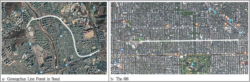
We selected two linear parks, the 606 in Chicago, U.S., and the Gyeongchun Line Forest in Seoul, Korea, for three reasons. First, both were built on disused railroads. Since the High Line in New York achieved enormous success in economic returns (Ascher and Uffer, 2015; David and Hammond, 2011), many cities both in the U.S. and worldwide have launched similar urban redevelopment plans to replace disused railroads with linear parks (Berg, 2017). Both study sites can be considered among the parks that followed this trend. Second, both parks cross the centers of residential areas. Parks can be a major cause of gentrification (Lim et al., 2013), and housing gentrification is becoming an important issue in residential areas (Atkinson, 2004; Bailey and Robertson, 1997). Third, these parks are representative of linear parks in U.S. and Korea. We can identify differences and similarities between them by comparing the two parks.
The 606 was built on the Bloomingdale Line, which connected the east and west sides of Chicago. The line was built in 1873 and offered services for passengers and commercial products. It stopped operations in 2001. In 1997, the Chicago Metropolitan Agency for Planning included this railroad in its Bicycle Facilities Development Plan. In 2003, the city announced a plan to convert the railroad (Gobster et al., 2017), and in 2004 it included this project in the Chicago Park District’s Logan Square Open Space Plan (LSOSP) for turning abandoned railroads into green spaces. The LSOSP aimed to (1) increase public open spaces such as parks, plazas, greenways, and outdoor places, (2) improve the quality of existing open spaces, (3) investigate recreational and open spaces on the Bloomingdale rail line, and (4) work with communities. The initial plan for the 606 was to provide boulevards, bike routes, and trails on the railroads (The City of Chicago, 2004). At the same time, the Friends of the Bloomingdale Trail was founded as an advocacy group to support the plan.
The Seoul Metropolitan Government promoted the Gyeongchun line double-track railway project in December 2010, and the 8.5-km section from Kwangwoon Station to Gurimae Station in Guri became a closed railroad site. Gyeongchun Line was decommissioned in December 2010 due to the suspension of the Mugunghwa-ho train and was left unattended due to illegal dumping and unauthorized building. The city has been operating urban regeneration projects since 2013, preserving old train tracks and structures and constructing a linear forest path with trees and flowers while preserving the railway tracks. These are 6 km long, starting from Gyeongchun Railway Bridge and running to the border between Seoul and Guri. It takes about two hours to walk along the forest road. In May 2015, 1.9 km from the Gongdeok second railroad crossing were opened. In November 2016, a 1.1-km section from the entrance of Seoul National University of Science and Technology to Hagye-dong was opened to citizens.
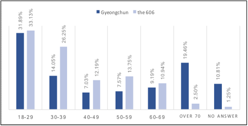
A survey was conducted from April to October 2019. At least three weekdays and three weekend days were given to the survey at each linear park. The survey asked several questions about motivations, travel patterns, activities, and benefits. Activities at the parks were mainly physical ones, such as walking, hiking, running, jogging, and walking dogs, or social activities such as chatting with friends, picnicking, relaxing, or doing nothing. The 606 survey had 320 respondents and the Gyeongchun Line Forest had 185. Most visitors to each park were age 18 to 29 (Refer to Figure 2). However, the second-largest age groups were quite different. At the 606, the younger generation (18—39 years old) visited more than other generations. In the Gyeongchun Line Forest, people over 70 visited more than other age groups. In the next section, the impact of this difference between the parks will be discussed in terms of connectivity, activities, and benefits.
Social media data was collected from Tweets which mentioned the keywords related each park such as ‘the 606’, ‘Bloomingdail trail’, ‘Gyeongchun Line Forest’, and ‘Gyeongchun Line Forest Trail.’ The total number of 14,340 for the 606 and 1,348 tweets for Gyeongchun Line Forest were scrapped by using Twitter API from January 2015 to June 2019. Since Gyeongchun Line Forest Trail opened to the public in 2019 completely, the total number of tweets were comparably lower than the 606.
This study mainly uses statistical analytics, such as descriptive statistics, principal component analysis, and linear regression. For each factor—connectivity, activity, or benefit—descriptive statistics are used. To find the relationship between activities and benefits, several sub-questions were asked of respondents, and three factors were derived from the PCA. Then a linear regression analysis was conducted.
In the case of the social media data, Korean tweets were translated to English before the analytics by using Google translator. After translating Korean tweets, the authors conducted the cluster analysis and draw bigram network diagram for understanding how people use the park.
Ⅳ. Results
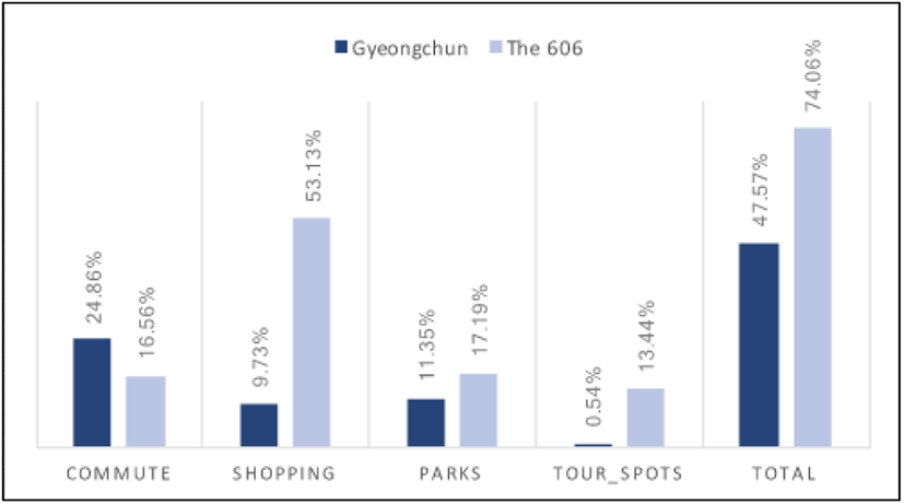
Connectivity is considered an essential feature of linear parks because of their form. Maddox (2016) claimed that it is a strength of linear parks in terms of catchment area (Maddox, 2016). In addition, if a railroad is replaced with a linear park, the park can be expected to connect places as the railroad did (Sim and Miller, 2019). But though theoretical reviews claim connectivity is a benefit of linear parks, in reality linear parks are rarely used for shortcuts or walkable routes to destinations. Only 56.88% of 606 visitors and 46.77% of Gyeongchun Line Forest visitors used the parks as routes to other destinations(Refer to Figure 3). On the 606, 53.13% of the visitors who used the park as a route to another place gave “shopping” as their final destination; this included coffee shops, banks, yoga classes, and restaurants. By contrast, visitors to the Gyeongchun Line Forest rarely used the park as a route to shopping (9.73%). Instead, the park was most popular for commuting. However, the Gyeongchun Line Forest Road opened more recently than the 606, so it may that small cafes have not developed around it. For the more accurate results on the relationship between small cafes and linear parks, further empirical studies are needed.
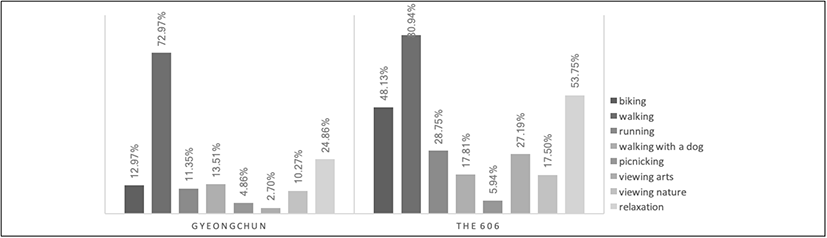
The survey also included visitors’ main activities, such as physical and social activities and enjoying nature. Figure 4 shows the results. Because visitors were asked to check all the activities they did in their visits, the total percentages exceed 100. In the Gyeongchun Line Forest, the main activities were physical ones, especially walking. Relaxation had the second highest rate, at 24.86%, but this was much lower than the relaxation rate of the 606, 53.75%. In general, visitors to the Gyeongchun Line Forest engaged in few activities: only 4.86% had picnics and 2.70% viewed artworks. By contrast, many visitors to the 606 participated in various activities, such as biking (48.13%), walking dogs (17.81%), viewing art (27.19%), and viewing nature (17.50%).
With these results, we can discuss the impact of design on visitors’ behavior. The 606 is a space designed for physical activities, especially biking and walking (The City of Chicago, 2004). However, the Gyeongchun Line was designed to provide a park to residents (Seoul Metropolitan Government, 2018). This difference between these purposes may have led to the different behaviors of the parks’ visitors (Kaplan, 1980; Kara, 2013). The findings suggest that parks with clear design concepts elicit particular actions. In the Gyeongchun Line Forest Road, visitors did little other than walking; in particular, less than 3% of visitors appreciated public art. Visitors to the 606, on the other hand, participated in various activities; all activities except picnics had participation rates above 15%. These results give us an idea of the design concepts behind linear parks.
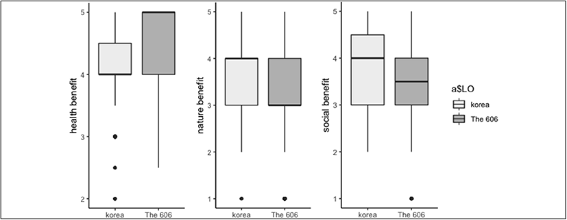
Six sub-questions about benefits were asked of visitors (Refer to Table 1), and three types of benefits—social, natural, and health benefits—were derived through principle component analysis (PCA). Generally, the means of health-related questions were higher (Q10.5, 10.6) than those of the other questions. This empirical test supports a previous study that claimed that main activities in linear park are physical ones (Kullmann, 2011; Sim et al., 2020; Sinha, 2014). After the PCA, a second sub-question was deleted due to low commonality. Figure 5 shows box plots of the three benefits. When asked about perceived benefits, 606 visitors mentioned health and nature rather than social benefits. Visitors to the Gyeongchun Line Forest listed social benefits first among the three, however.
| # of sub-questions | Gyeongchun | The 606 | Total |
|---|---|---|---|
| Q10.1 | 3.9 | 3.39 | 3.58 |
| Q10.2 | 3.92 | 4.35 | 4.19 |
| Q10.3 | 3.95 | 3.46 | 3.64 |
| Q10.4 | 3.9 | 3.59 | 3.7 |
| Q10.5 | 4.02 | 4.48 | 4.31 |
| Q10.6 | 4.05 | 4.53 | 4.36 |
This result can also be discussed in relationship with the design concept of the park. As mentioned earlier, the design concept behind the 606 was physical activity, whereas the Gyeongchun Line Forest is more of a resident-friendly park, including more diverse activities such as social gatherings. In line with the design concept, 606 visitors said they saw the most health benefits. Visitors to the Gyeongchun Line saw the most social benefits, followed by natural and health benefits. The important point here is that the Gyeongchun Line Forest, which has a diversity of design, is a suitable space for social meetings. It can also be seen that parks that provide space for social encounters benefit their users.
A linear regression was conducted to determine the relationship between activities and perceived benefits. Activities were divided into four groups: physical, nature-friendly, social, and relaxation. Benefits were grouped into three: health, natural, and social(Refer to Figure 6). Table 2 shows the results, focused on t-value.
First, physical activity has a complex relationship with all three benefits in each park. In the case of 606, jogging and running have a positive relationship with health and nature benefits. Dog walking also has a positive relationship with nature and social benefits. However, hiking and walking have a negative relationship with social benefits. The Gyeongchun Line Forest shows different results. Cycling has a negative relationship with nature benefits due to the speed of the activity. Hiking and walking are related social and nature benefits more positively. Jogging and running also have a positive relationship with social benefits. Second, nature-friendly activities such as viewing and touching trees and flowers also have different results. On the 606, these activities have no relationship with any benefit. In the Gyeongchun Line Forest, they have positive relationships with all three perceived benefits. Third, social activities such as picnics are similar between the two parks. Picnic are positively related to social benefits in both parks, which could be because social activities have social benefit that cross cultural divides. Fourth, relaxation activities on the 606 have a negative relationship with health benefits and a positive relationship with social benefits. But where the 606 shows complex results, social activities in the Gyeongchun Line Forest show no relationships with any benefit.
The most striking thing about these results is that the same physical activities have different benefits, depending on the park. Hiking and walking reduced social benefits on the 606, but contributed to increased social and natural benefits in the Gyeongchun Line Forest. What this means is that a single physical activity can have benefits that depend on cultural and design differences. The 606 was designed for physical activity and is visited by people for that purpose; as a result, there may be social interaction than movement. However, the Gyeongchun Line Forest prioritizes use by residents over physical activities, so walking produces more social benefits.
On the 606, viewing nature has no natural benefits, but in the Gyeongchun Line Forest it has statistically significant benefits in all three areas. However, the same interpretation on the basis of design is possible. In the Gyeongchun Line Forest, people are satisfied by seeing nature because of the diversity of the design; and picnicking, a social activity, increases social benefits in both parks. This supports the validity of this empirical study.
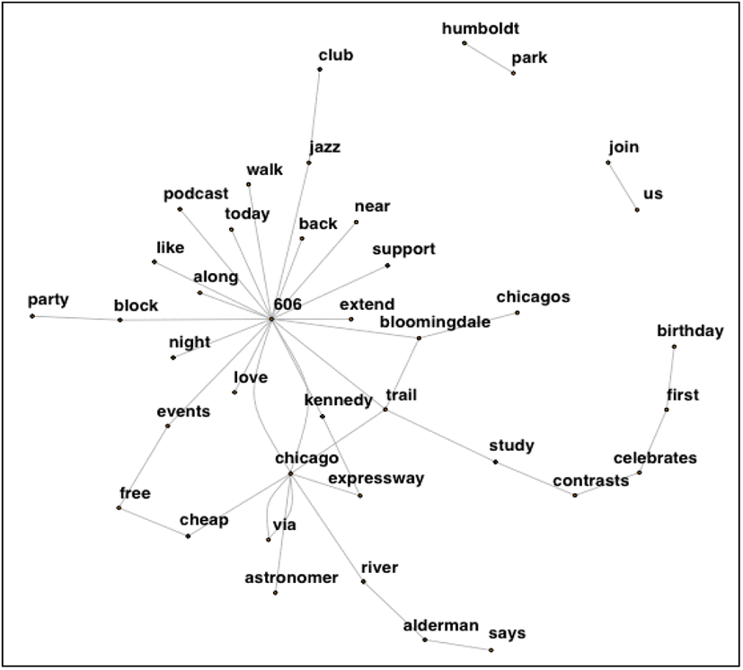
Bigram network represents the relationship between related words. For example, if a user tweeted ‘I walk Gyeongchun Line Forest’, bigram network analysis paired the words into two related words such as ‘i-walk’, ‘walk-Gyeongchun’, ‘Gyeongchun-Line’, and ‘Line-Forest.’ Which means the bigram network analysis shows the most related words and the relationship between words. By using this analysis, we may know how people think about the park and what they do in the park.
Figure 7 and Figure 8 represent the diagram made by bigram network analysis. When we followed the line from a node, ‘606’, we could find the related words that ‘606-events-free-cheap-chicago-trail.’ It can be considered the 606 users frequently mentioned those words in a sentence and events can be also considered an interesting thing for visitors. When we scrutinized the diagram, we might find ‘love-606’, ‘near-606’, ‘like-606’, and ‘support-606’. Those paired words represented the attitudes of the residents or social media users that they love or like the 606 trail and promoted to support this trail. Also, we could find casual words liked ‘walk’, ‘night’ with ‘606’ which represented how people use this trail.
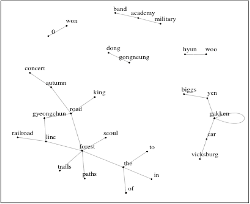
For the Gyeongchun Line Forest, we draw the simple diagram by using the same analytics with the 606. People who use the Gyeongchun Line Forest more interested in ‘event’ with k-pop star such as Biggs rather than the park itself. When we see Figure 7, there are several isolated branches. Which means social media users who mentioned Gyeongchun Line Forest more interested events opened at the park rather than visiting the park to enjoy the park. only a few branches showed the Gyeongchun Line Forest, people mentioned the words liked ‘autumn’, ‘paths’, ‘trails’, and ‘railroad’. However, the information that is contained in the diagram is much insufficient than the 606’s because of the volume of the tweets for the Gyeongchun Line Forest are much insufficient than the 606.
Ⅴ. Conclusions
This study examines the relationship between park design and behavior of residents by selecting representative linear parks of two different cultures. Overall, this study is meaningful for addressing the recent issue of replacing railroads with parks. Among these, parks located in residential areas were selected. However, it may be a limitation that cultural differences are not considered in the research results. This is because racial and cultural backgrounds are closely related to people’s behavior, especially in the use of parks (Arnold and Shinew, 1998; Byrne and Wolch, 2009). In the future, studies that compensate for these limitations will be needed.
This study also explores the three components of the model of landscape perception—human, landscape, and outcome—in terms of connectivity, behavior, and benefits. Since the 606 trail in Chicago and the Gyeonchun Line Forest in Seoul have the differences between each culture, the USA and Korea, it may contain fundamental difficulty to compare these sites by using the same methods. In the future study, the differences between two cultures have to be mentioned and controled.
By looking at the relationship between behavior and benefits, we can see which behaviors lead to which benefits. First, connectivity is a typical feature of linear parks, and it was initially supposed that people would use them as shortcuts to other places, but in fact only about half of visitors use these parks as routes to other places. Significantly fewer people use the Gyeongchun Line as a route than use the 606 that way. However, what is special about the 606 is that most users mention cafes and restaurants as their final destination when using the park as a route; far fewer Gyeongchun Line users do so. This could be because the 606 opened before the Gyeongchun Line, and many more cafes have been opened around it.
Second, in terms of how people use the parks, 606 users engage in a variety of actions, but visitors to Gyeongchun Line did not do anything other than walk. This can be thought of in connection with the design concept of each park. The 606 had a clear design concept: it was designed for physical exercise. The Gyeongchun Line was intended as a resident-friendly park. And on the 606, not only do various physical behaviors occur, but also various other categories of behavior, such as appreciation of art and social interaction. The Gyeongchun Line, on the other hand, has very low percentages of people involved in activities like are appreciation and picnics. This suggests that it is a clear design concept, rather than a variety of designs, that varies people’s behavior.
Third, the benefits people gained from using these parks were, in order, health, social, and natural benefits for 606 users, and social, natural, and health benefits for Gyeongchun Line users. Benefits can also be thought of in connection with design strategies. On the 606, health benefits had the highest response rates because the park was designed for physical activity. Gyeongchun Line, by contrast, is a resident-friendly park that contributes mostly to social benefits.
Fourth, the relationship between behavior and benefits was different in each park. On the 606, activities such as jogging and running increased health and provided natural benefits; but in the case of Gyeongchun, they provided social benefits. This can be interpreted in terms of the nature of running in Korea, because of its cultural background with friends and family. For 606 users, walking with a dog also provided social benefits.
Fifth, in terms of the social media analytics for linear parks or urban parks, text mining liked the bigram network analysis can be used for identifying people’s attitudes and their thoughts about the park. One of the important thing is to secure the volume of data to get a rich information from the data set. In the case of the 606, the results show the rich information about the park, however the Gyeongchun Line Forest which doesn’t have the rich data show insufficient information.
In conclude, this study allows landscape architects, urban planners, and architects to understand a way to using social media analytics and a survey for reading a site and users’behavior in detail. In terms of social media data, they still have a limitation to use in real environments. However, if we use the social media analytics with a survey, we may provide information about the relationship between the place and people in deeply.