


1. Introduction
Rice paddies, where rice, the staple diet of Korea (Korean National Committee on Irrigation and Drainage, 2001) is grown, maintain the agricultural landscape and cultural traditions of rural villages (Nam, 2010). Rice paddies have diverse functions other than food production, such as flood control, air and water purification, climate mitigation, and biodiversity maintenance (Park et al., 1996), and this concept is called agricultural multi-functionality (Kang, 2007). The concept of paddy fields/wetlands was first proposed in the “Resolution on Paddy Field Wetland” at the Ramsar Convention in Changwon, South Korea in 2008 (Ramsar, 2008). This concept recognizes that paddy fields are not just for food production, but are important for the protection of the biodiversity of habitats. However, owing to the perception that rice paddies, including wetlands, are wastelands has encouraged their conversion to intensive agricultural, industrial, and residential uses (Barbier and Burgess, 1996).
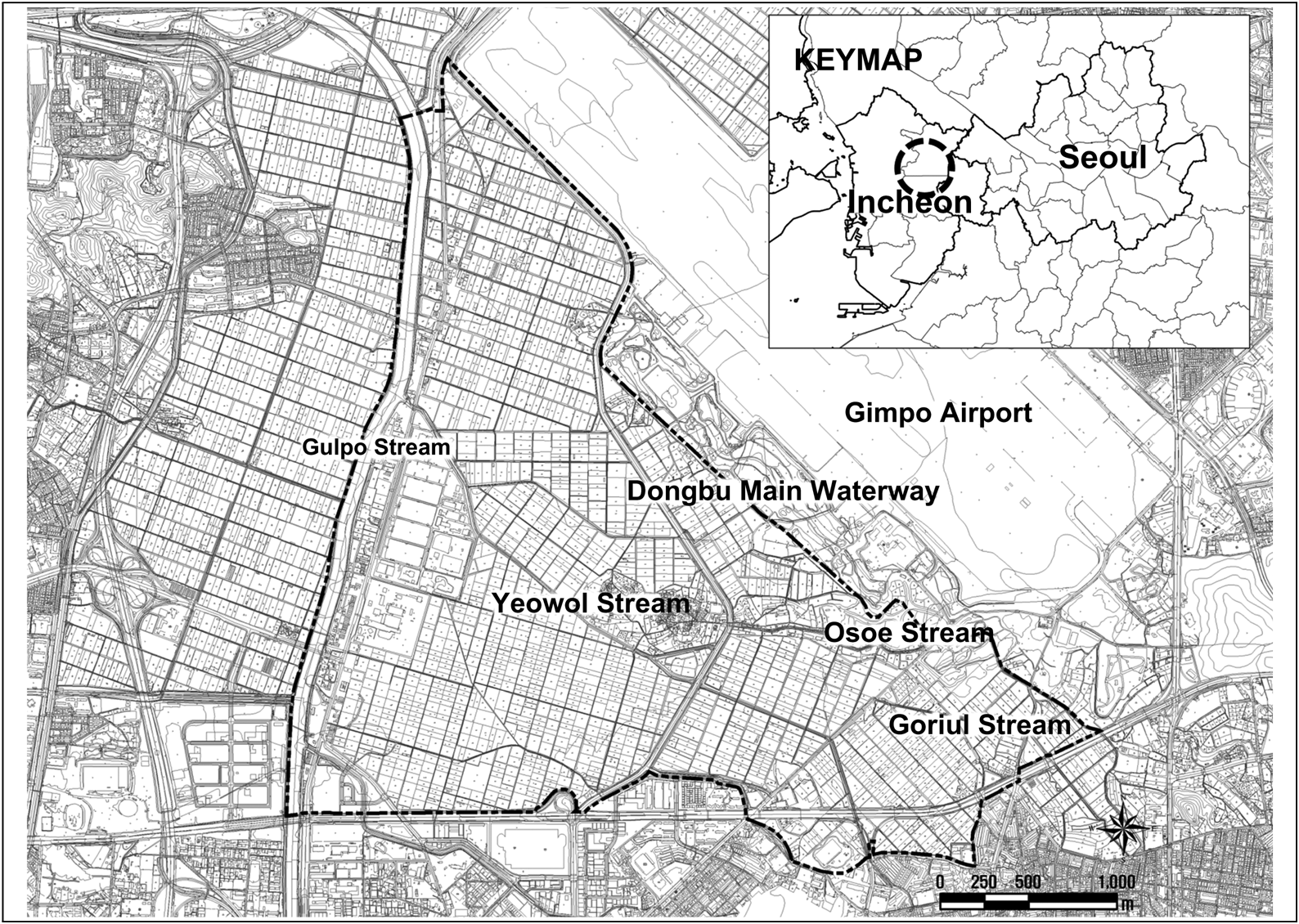
The target site, Daejang-dong District, is a paddy field of approximately 1,319 ha situated on the eastern side of the Gulpo Stream, including Daejang-dong and Gogang-dong in Bucheon City, near Gimpo Airport, and Ogok-dong in Gangseo-gu, Seoul. It is the closest large-scale paddy field to Seoul. Daejang-dong District provides a habitat for wildlife and has great ecological value, especially for protected/priority species such as white-naped crane (Antigone vipio), Seoul frog (Pelophylax chosenicus), bean goose (Anser fabalis), and boreal digging frog (Kaloula borealis). However, a plan for the provision of 300,000 housing units in the metropolitan area, the third New Town Development for Daejang-dong District, Bucheon, has been established and implemented on approximately 342 ha of cultivated land in the south of Yeowol Stream and Osoe Stream. Development is inevitable to revitalize the local economy, but if the paddy fields are indiscriminately destroyed considering only the economic effects of the development into a new city, the public value provided by the paddy fields and the environmental function as a living habitat will be lost, and the legacy that will be left to future generations will be lost. In addition, NGOs in Bucheon have carried out activities to protect species living in Daejang-dong District, so that they can cultivate civic awareness based on the value of Daejang-dong District as a treasure trove of the education of ecosystem and the only wind road in Bucheon. As the area of the paddy fields is likely to decrease as the city expands due to the influence of some of the Daejang-dong District being designated as new cities, it is necessary to designate a living habitat that can prevent the expansion of the city, support the comfortable life and leisure activities of local residents, and preserve living habitats.
Marxan with Zones classifies terrestrial and marine zones into various specific use districts and establishes various levels of conservation areas (Watts et al., 2009) based on ecological, socioeconomic, and cultural data (Ardron et al., 2010). Therefore, Marxan with Zones supports decision-making in a variety of fields, including land-use, marine, urban, and regional planning, and helps establish conservation-oriented use of districts. The outcomes of the analysis of alternatives using Marxan with Zones can facilitate decision-making processes among stakeholders by identifying areas with high conservation priority (Klein et al., 2008). Loos (2006) indicated that various specific use districts can be established through an iterative process. Bos (1993) applied a simulated annealing algorithm to harmonize local appropriateness for forest policy. Mo (2013) investigated the expansion of protected areas in Pyeongchang, Gangwon Province, South Korea, and argued that large patches with a relatively large number of conservation targets are highly likely to become protected areas.
The aim of this study was to select appropriate habitats that reflect the ecological characteristics of urban paddy fields and occurrence status of species utilizing Marxan with Zones, which is a decision-making program that reflects the ecological status in setting conservation areas and contributes to efficient zoning at a minimum cost. In this study, we compiled data on existing vegetation and protected species in Daejang-dong District, a representative urban paddy field near Seoul. Using this ecological information, we analyzed Marxan with Zones and developed two conservation plans. These plans, based on spatial maps, are intended to assist decision-makers.
2. Methods
We conducted a field survey on March 5, 2021 to examine the current status of land uses and actual vegetation along waterways to identify spaces with necessary environmental characteristics required to function as habitats. We categorized Biotopes based on this evaluation. Furthermore, as Daejang-dong District is maintained by an artificially regulated water circulation system, called an agricultural ecosystem, we analyzed the water system to derive appropriate habitats. Finally, we conducted field surveys to analyze the inhabitation and distribution statuses of wild birds and amphibians to identify areas that currently function as key habitats. We surveyed wild birds during winter (December 9, 2019), spring (March 26, 2020), and summer (July 10, 2020). We surveyed amphibians seven times from March to August during 2018–2020. The collected environmental and ecological status data were spatially correlated using ArcGIS 10.8.
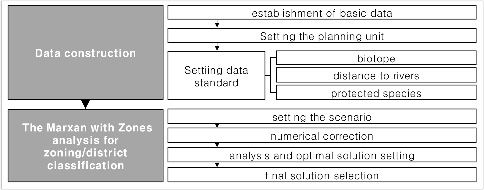
Daejang-dong District is adjacent to the Han River. Owing to its flat topography and lowlands, the distance to rivers connected to agricultural waterways inhabited by species is considered an important factor. Biotope and species occurrence were correlated to derive areas that can function as habitats. Therefore, Biotope, protected species, and distance to rivers indexes were selected as mapping indicators. The Marxan with Zones analysis for zoning/district classification was performed using the following steps: establishment of basic data to set the planning unit and input files, data standard setting, numerical correction, analysis and optimal solution setting, sensitivity analysis, and final solution selection. In the data construction phase, we utilized ArcGIS 10.8 to set rivers and agricultural waterways as planning units, and Biotope, distance to rivers, and protected species indexes were set as input indicators. The location of the occurrence of species was set and reflected in the feature file. Data standards were set using the weight per basin (zone cost), characteristic index per region (zone target), and contribution to the characteristic index (zone contribution). After setting the standard, numerical correction was made to reduce data errors (Figure 1).
3. Results
Daejang-dong District is a paddy-cultivating area that spans Daejang-dong, Bucheon City, and Gangseo-gu, Seoul, where is the largest cultivated area adjacent to Seoul. The site is located at 455 Daejang-dong, Bucheon City, and is the planned development site of the Bucheon Daejang Public Housing District. The Gulpo Stream that merges into the Han River flows to the west of the site. The Yeowol Stream that transports agricultural water crisscrosses paddy fields. The Eastern Intracoastal and Dongbu Main Waterway, which supplies water to the surrounding rice fields, is to the east of the site. Daejang Village and Gimpo Airport are located to the northeast of the site (Figure 2).
Daejang-dong District were reed wetlands where the Han River and Gulpo Stream overflow every year in Joseon dynasty before Japanese colonial period. After that, during Japanese colonial period, a Singok drainage field was established in accordance with Rice Granary Policy Management of the Japanese General Government, and Gulpo Stream was maintained, and the Gimpo Plain, including Daejang-dong District, was transformed into large-scale agricultural land (Han, 2016).
The large agricultural land formed in this way became the basis for growth for living organisms living on the basis of paddy wetlands. Due to their morphological characteristics, the Seoul frog and the boreal digging frog, which are endangered wild animal Class II, have a distance of about 500m from the breeding place to the living place (Shim, 2001; Park et al., 2018). Therefore, a large number of Seoul frogs and boreal digging frogs live in Daejang-dong District, where rice fields are widely distributed. After Hongdo Plain, which is about 10km away from Daejang-dong District, were turned into a residential complex, the red-crowned crane chose Daejang-dong District as an alternative wintering site (Han, 2016). The red-crowned cranes winter in an Daejang-dong District because it is close to the Han River, which is a sleeping site, and the fall grains remain in the rice fields in winter.
The Biotopes were categorized by synthesizing the land-use status of Daejang-dong District and actual vegetation status along waterways (Figure 3); they were categorized as major and medium based on land use. Medium Biotopes included artificial waterway, natural meadow, wet agriculture, dry agriculture, plastic tillage, recreational infrastructure land, general facility land, and special areas.
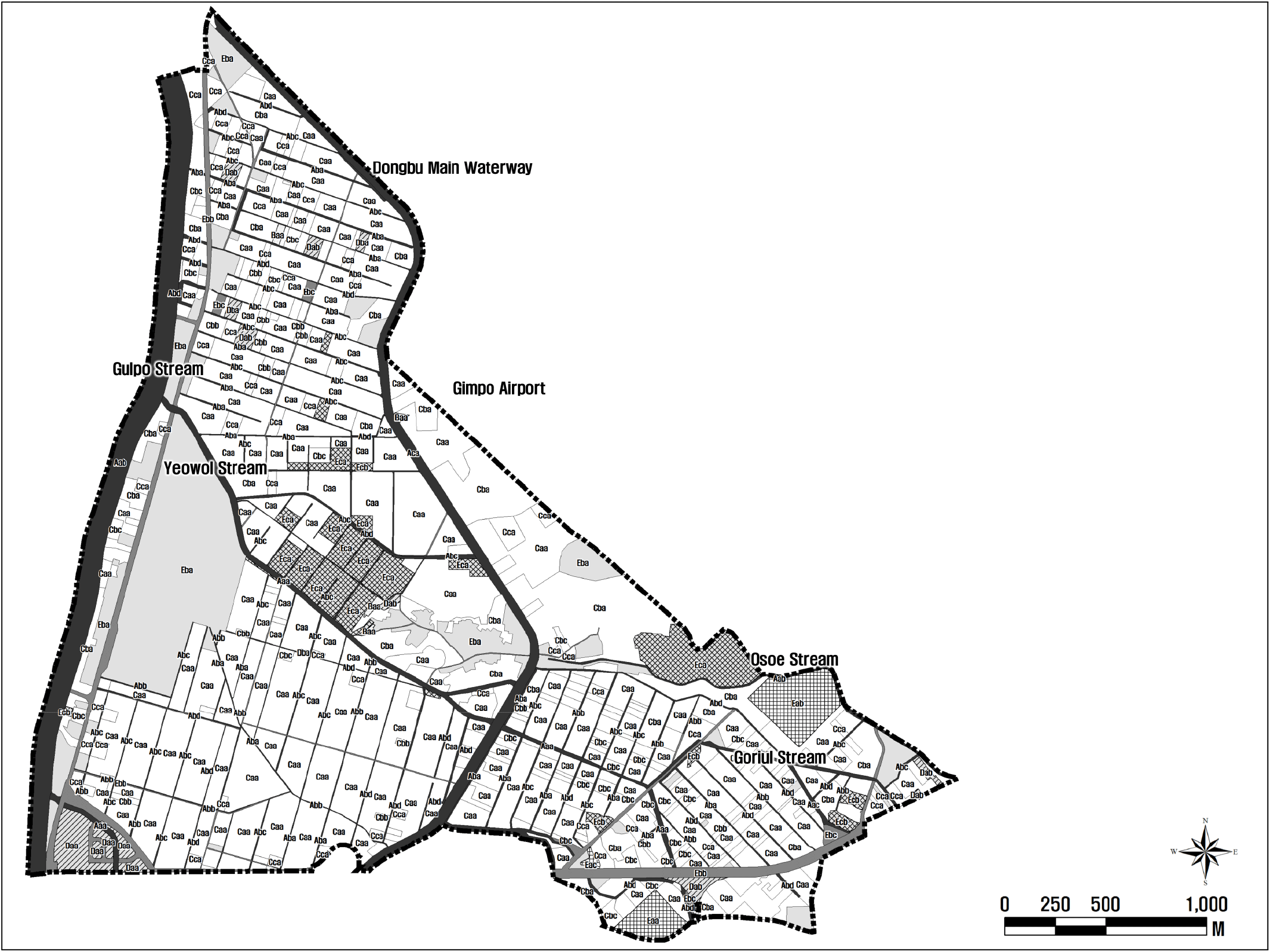
The medium Biotopes were further classified into small river, agricultural waterway, and bare land with and without vegetation based on the types of actual vegetation present along waterways. In total, 42 classification types, namely, 5 major, 12 medium, and 25 minor, were derived. Among the major classification types, cultivated land was the most common (65.1%), followed by urbanized areas (20.3%), rivers (13.0%), bare land (1.5%), and meadows (0.1%). Among the river types, artificial small rivers dominated by wetland vegetation accounted for 5.4%, including the Gulpo Stream. Artificial waterways were dominated by wetland vegetation and accounted for 1.5%, including the Eastern Intracoastal and Dongbu Main Waterway. Other small rivers included the Yeowol Stream, Gyulhyeon Stream, and Oseo Stream, and agricultural waterways corresponding to waterways between cultivated fields. Among the cultivated land, rice paddies and other fields accounted for 43.6% and 15.8% of the area, respectively, occupying the largest areas. Paddy fields were mostly distributed in the southwestern part of Daejang-dong District between Gulpo Stream and Yeowol Stream, followed by the northern part of Yeowol Stream and eastern part of the Eastern Intracoastal and Dongbu Main Waterway. Fields were mostly located on the eastern side of the Eastern Intracoastal and Dongbu Main Waterway and northern side of the Yeowol Stream but less distributed in the southwestern side of Daejang-dong District. Other cultivated fields were orchards, nursery fields, and plastic tilla.
The medium classification type assessment was based on the Biotope type assessment goals, which are to maximize the conservation of species and habitats and recreational opportunities, whereas the minor classification type assessment was based on naturalness, self-sufficiency, usability, and ecological function. The Biotope type was synthesized from the major and minor classification type assessments using a matrix method.
Five Biotope types were identified. Class Ⅰ accounted for 0.2% of the total area corresponding to the Gyulhyeon Stream, a natural small river dominated by wetland vegetation. Class II had the largest area, at 46.9% of the total area and included rice fields and artificial and natural small rivers dominated by foreign/invasive vegetation, such as the Yeowol Stream. Class III accounted for 33.0% of the total area and encompassed cultivated land other than rice paddies, agricultural waterways, bare land with native vegetation, dry fallow field meadows dominated by foreign species, parks, and golf courses. Class IV accounted for 16.4% of the total area and included artificial waterways with wetland vegetation and waterfronts, such as the Eastern Intracoastal, Dongbu, Western Intracoastal, and Seobu Main Waterways, as well as bare land with foreign vegetation or without vegetation, urbanized areas excluding transportation facilities, and construction sites. Class V accounted for 3.6% of the total area and included transportation facilities in urbanized areas and open-air storage yards in special areas (Figure 3).
Daejang-dong District has a water system that is artificially regulated to maintain cultivation (Figure 2). Since 1923, when the Singok pumping/drainage station and Eastern Intracoastal and Dongbu Main Waterway were constructed in the lower reaches at the point where the Gulpo Stream and Han River join, under the Increased Yield of Rice Policy of the Japanese Government–Government of Korea Project, it has been possible to pump agricultural water during droughts and rice-planting seasons and prevent flooding during rainy seasons through the Eastern Intracoastal and Dongbu Main Waterway. The Eastern Intracoastal and Dongbu Main Waterway enables the acquisition of agricultural water from the Han River and provides sources of food, such as fish and microorganisms, for wild birds. The water taken from the Eastern Intracoastal and Dongbu Main Waterway is transported to rice fields through feeder canals distributed among the cultivated fields in Daejang-dong District. When the rice fields are drained to prevent root rot and increase vitality, the water is gathered in the Yeowol Stream and flows to the Gulpo Stream, which is drained to the Gyeongin Ara Waterway.
Rice fields in Daejang-dong District are distributed through agricultural waterways to enhance the supply and drainage of water. These waterways can be categorized into natural and artificial agricultural waterways based on the shape and material of their slopes. The slopes of artificial agricultural waterways are constructed at a right angle using concrete, and most of them are feeder channels that supply agricultural water from the Eastern Intracoastal and Dongbu Main Waterway to prevent water from flowing through the soil and rock and ensure a smooth supply. By contrast, natural agricultural waterways are often sloped using soil and contain common vegetation. As the water used in rice paddies is drained into the Yeowol Stream, unlike that in the artificial type, the water is lost through the porous soil and rocks.
We surveyed the distribution of amphibians between June and August from 2018 to 2020 and found 13,507 individuals of three species. These amphibians were mainly found in cultivated fields, stream, and fallow field meadows and consisted of boreal digging frog (Kaloula borealis), Seoul frog (Pelophylax chosenicus), and dark-spotted frog (Pelophylax nigromaculatus). The boreal digging frog and Seoul frog, which are Class II endangered species of wild fauna and flora, were found in large numbers, with 10,549 and 2,925 individuals, respectively.
In total, 3,951 individuals of wild birds belonging to 44 species were observed in Daejang-dong District on December 9, 2019, March 26, 2020, and July 10, 2020. In winter, many wintering ducks feeding on the water surface, such as bean goose and common teal (Anas crecca), were frequently observed in the Gulpo Stream and Eastern Intracoastal and Dongbu Main Waterway, and more species and individuals were observed in winter than in spring and summer. In spring, winter migratory birds, such as eastern spot-billed duck (Anas zonorhyncha) and tufted duck (Aythya fuligula), were found in the Gulpo Stream and Eastern Intracoastal and Dongbu Main Waterway, and resident birds, such as grey-capped greenfinch (Chloris sinica) and vinous-throated parrotbill (Suthora webbiana), were mainly found around cultivated fields. In summer, grey heron (Ardea cinerea) and eastern great egret (Ardea alba modesta) belonging to the family Ardeidae, which feed around the water, occurred in large numbers. Unlike in winter and spring, wild birds were not found in the Gulpo Stream and Eastern Intracoastal and Dongbu Main Waterway in summer; however, numerous wild birds were found in the Yeowol Stream. Five legally protected species classified as Class II endangered species of wild fauna and flora were surveyed: Eurasian goshawk (Accipiter gentilis; Natural Monument No. 323), common kestrel (Falco tinnunculus; Natural Monument No. 323-8), Eurasian hobby (Falco subbuteo Linnaeus), bean goose, and white-naped crane (Antigone vipio; Natural Monument No. 203). The most abundant species was the greater white-fronted goose (Anser albifrons), with 1,500 individuals. In total, 2,238 individuals of species in this guild were observed foraging on the water surface or at the edge of the water body, including greater white-fronted goose, which accounted for a high proportion, 56.6%, of the total population.
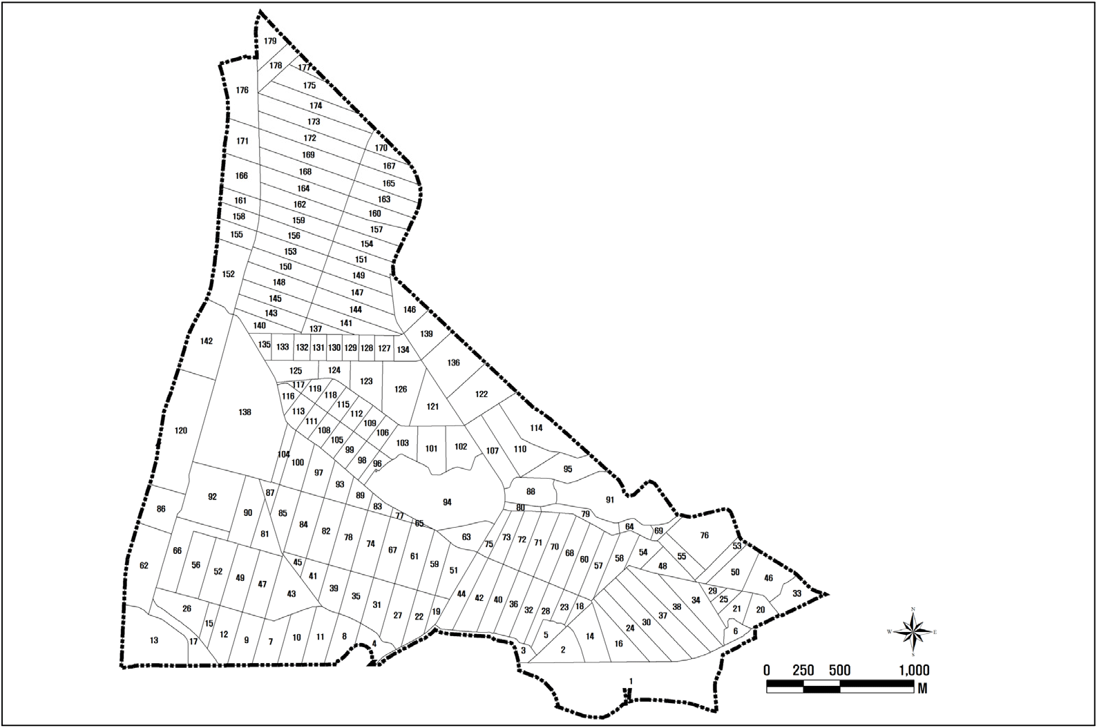
Daejang-dong District is a paddy wetland and its ecosphere is formed by the structure and biological factors of agricultural waterways. Therefore, we applied the watershed concept to evaluate the distribution status of rivers and agricultural waterways and set the area in which water is collected as the planning unit for spatial analysis. One planning unit area was divided to include one rice field or another field on each side with an agricultural waterway in the center, and the urbanized area was not divided but was set as one planning unit. As rainwater and agricultural water are collected in rivers and agricultural waterways, the areas where water is collected were set as one planning unit. Thus, Daejang-dong District was classified into 240 planning units (Figure 4).
 Research Site,
  Planning Unit
The average Biotope index of Daejang-dong District was 0.56. Overall, 35.3% of the total area had a Biotope index of ❭ 0.6 encompassing 102 watersheds with an average Biotope index of 0.65, 35.3% of the total area had a Biotope index of 0.5–0.6 encompassing 85 watersheds with an average Biotope index of 0.56, 15.1% of the total area had a Biotope index of 0.4–0.5 encompassing 28 watersheds with an average Biotope index of 0.46, 5.2% of the total area had a Biotope index of 0.3–0.4 encompassing 13 watersheds with an average Biotope index of 0.36, and 9.1% of the total area had a Biotope index of ❬ 0.3 encompassing 12 watersheds with an average Biotope index of 0.26. Areas with high Biotope indices were mostly cultivated land, of which the proportion of paddy fields was high, and higher Biotope indices were associated with closer proximity to small rivers.
We calculated the direct distance to stream per watershed, listed the length values, and categorized them into four types: ❬ 10, 10–100, 100–200, and ❭ 200 m. There were 155 watersheds at a distance of ❬ 10 m to the stream, accounting for 68.3% of the total area. The closer to the stream, the more diverse the habitat and abundant the food source; hence, an index of 1.0 was assigned to them. There were 20 watersheds between 10 and 100 m, and an index of 0.7 was assigned to them. There were 29 watersheds between 100 and 200 m, with an index of 0.5. There were 36 watersheds of ❭ 200 m, and we assigned a value of 0 because they are considered to be less directly affected by the stream.
We counted the protected species per watershed, listed the values, and categorized them into five types: ❭ 100, 50–100, 10–50, 1–10 individuals, and no protected species. There were 90 watersheds with ❭ 100 individuals of protected species and 26 watersheds with 50–100 individuals. There were 29 watersheds with 10–50 individuals and 66 watersheds with 1–10 individuals. Protected species were found in the areas corresponding to 68.6% of the total area, which included 211 watersheds.
We prepared three zoning scenarios with the area ratio of Zone A (core conservation area), Zone B (buffer area), and Zone C (buffer area). The three zones were based on the minimum area probability (MAP) of 95%, 75%, and 50%, which is the estimated ratio of the kernel (Worton, 1989) that enables deriving the home range of wild animals through a line expressing the space utilization of relevant entities based on the density of occurrence.
Among the targets, the sum of Zone A (core conservation area) and Zone B (buffer zone) areas was reflected as the ratio of the MAP; the conservation intensities of Zones A, B, and C were set as 95%, 75%, and 0%, respectively.
In Article 5 of the Enforcement Regulation of the Act on Urban Parks and Green Areas, a development plan of 3.3 million square meters or more is stipulated to create green areas, with a larger area of 12 square meters or more per resident population or 20% or more of the development site area. Therefore, ZONE A was set at 20% or more and 40% or less, the maximum of the green area ratio of the five 3rd new towns. In addition, scenario ZONE B was set higher in scenario 2 than in scenario 1 according to the ratio of ZONE A, and scenario 3 set ZONE B at 5% to maintain the ratio of the used area.
In scenario 1, the area ratio of Zone A was set to 20%, Zone B was set to 10%, and Zone C was set to 70%. In scenario 2, the area ratio of Zone A was set to 30%, Zone B was set to 15%, and Zone C was set to 55%. In scenario 3, the area ratio of Zone A was set to 40%, Zone B was set to 55%, and Zone C was set to 55%.
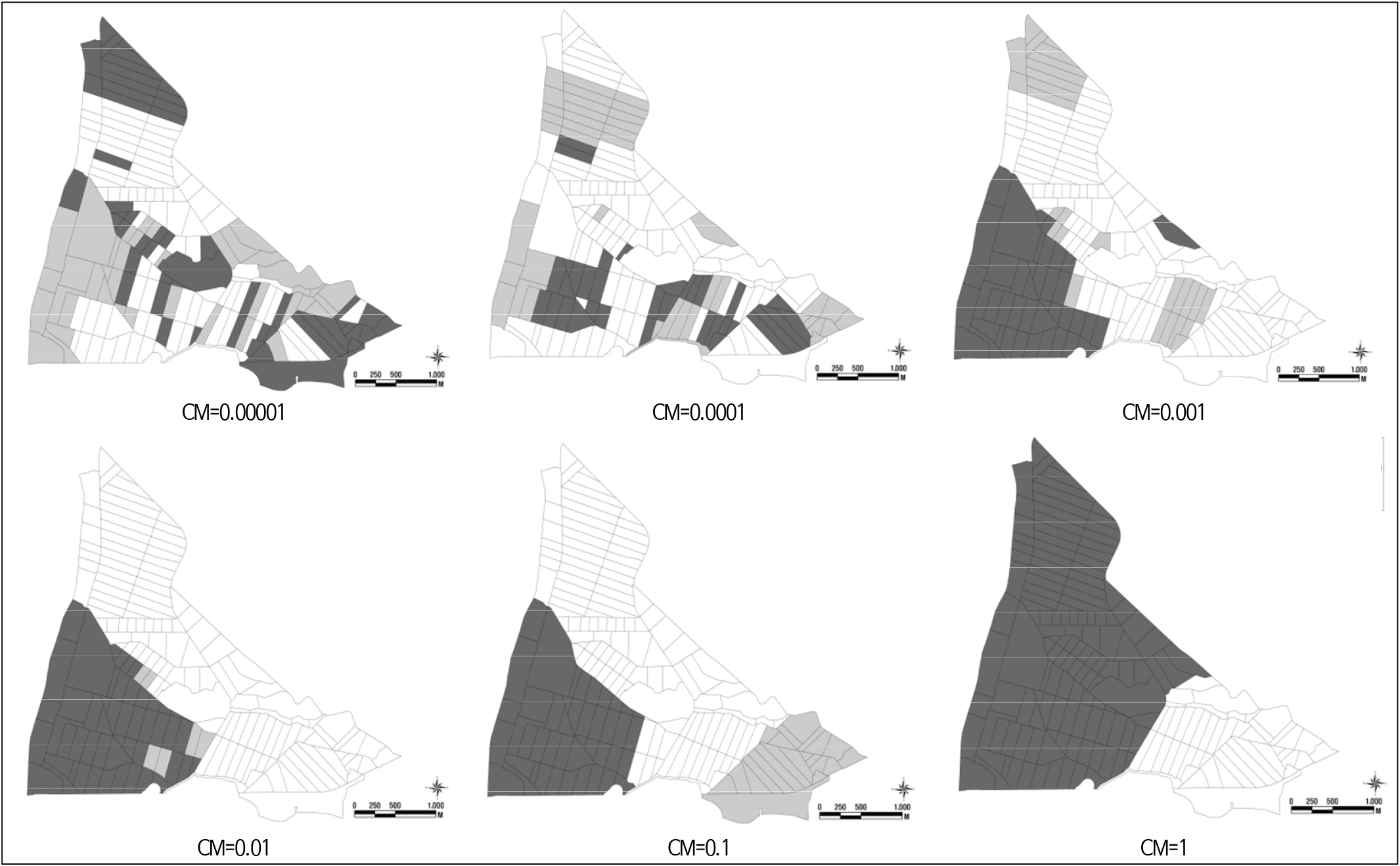
Baseline metric (BLM) value for Daejang-dong District was determined based on 95% of the highest conservation value of the characteristic indicator among the values presented in the research methodology framework. To determine the BLM value, as outlined in the user guide for the application of Marxan with Zones (Watts et al., 2008), we performed several analyses, adjusting the values from 0.00001 to 10 in increments of 0.0001, 0.001, 0.01, 0.1, 1, 2.5, 5, 7.5, and 10. For cases where the number of districts was maintained at three (Zones A, B, and C), the ratio of the shortest outer length to the sum of the area of zones was set as the BLM value. After fixing the BLM value, numerical correction was performed to confirm the most efficient purpose function value (score) according to the number of iterations. Starting from the initial value of 1,000,000 iterations, we repeatedly analyzed 500,000, 100,000, 50,000, 10,000, 5,000, and 1,000 iterations. The numerical values that decreased to 0 in the annealing algorithm were set to 10,000, 5,000, 1,000, 500, 100, 50, and 10, considering the ratio to the initial value. As a result of numerical correction, the number of iterations with the lowest purpose function value was fixed. The false positive factor (FPF), which is a characteristic indicator correction factor, corrects the occurrence value that excludes the characteristic indicator. After fixing the BLM value and number of iterations, the FPF was corrected. The numerical correction of the FPF was performed using the number of points at which the occurrence of wild birds, amphibians, and endangered species was observed (Watts et al., 2008). The zone boundary cost, which is the final numerical correction step, BLM, iteration number, and FPF value were fixed. The connectivity value between the core conservation area and buffer zone, buffer zone and use zone, and core conservation area and use zone was set to 0.00001. The connectivity was analyzed by increasing the value to 0.0001, 0.001, 0.01, 0.1, and 1. Finally, we validated the scenario through four steps. As a result of numerical error corrections via sensitivity analysis and iteration number and the numerical correction of the zone boundary cost, we obtained six scenarios ranging from CM = 0.00001 to CM = 1, for scenarios 1, 2, and 3 (Figure 5).
 A (Core area),
  B (Buffer area),
  C (Use area)
Scenario 1 with Phase 4, in which planning units with a large population of animals such as wild birds, amphibians, and reptiles are included, should encompass the south of Daejang-dong District situated between the Yeowol Stream and Goriul Stream. Corresponding to this case, CM = 0.00001 fulfilled Phases 1, 2, and 3. As the scenario with CM = 0.00001 satisfied the target core conservation area ratio of 20%, it was selected. In this scenario, small rivers such as the Yeowol Stream and Osoe Stream are adjacent to the core conservation area. Scenario 2 with Phase 4, in which planning units with a large population of animals such as wild birds, amphibians, and reptiles are included, should encompass the south of Daejang-dong District between the Yeowol Stream and Goriul Stream. Corresponding to this case, CM = 0.00001 and CM = 0.01 fulfilled Phases 1, 2, and 3. Therefore, the scenarios with CM = 0.00001 and CM = 0.01 were selected. Both scenarios satisfied the target core conservation area ratio of 30% in which the core conservation area is adjacent to small rivers such as the Yeowol Stream and Goriul Stream. Furthermore, the core conservation area is concentrated near the Yeowol Stream with a large population of protected species. Scenario 3 with Phase 4, in which watersheds with a large number of animals such as wild birds, amphibians, and reptiles are included, should encompass the south of Daejang-dong District situated between the Yeowol Stream and Goriul Stream. Corresponding to this case, the scenario with CM = 0.00001 fulfilled Phases 1, 2, and 3. Therefore, the scenario with CM = 0.00001 was selected. The scenario with CM = 0.00001 met the target core conservation area ratio of 40%, and its core conservation area is adjacent to small rivers such as the Yeowol Stream, Osoe Stream, and Bernae Stream (Figure 6).
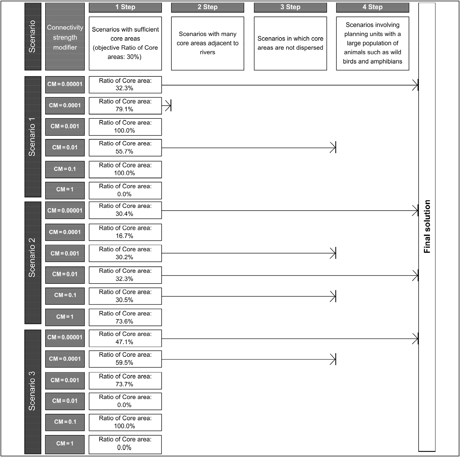
Among the three scenarios analyzed using Marxan with Zones for Daejang-dong District, Scenario 2, in which the core conservation area ratio was set to 30% or higher, yielded results that reflect different perspectives. In Scenarios 1 and 3, only one case with CM = 0.00001 was derived as the solution scenario. Therefore, Scenario 2 was selected as the appropriate scenario, and the two solutions were classified as decentralized and centralized conservation areas.
4. Discussion
Seoul frog was mainly found in agricultural waterways and paddy fields, whereas boreal digging frog was found in large numbers in cultivated fields and fallow field meadows in Daejeon village. Rice fields provide a habitat with fields that can supply insects for adult amphibians and decaying vegetation for tadpoles, along with paddy banks for hiding. Daejang-dong District features uninterrupted expanses of rice paddies, making it is an ideal environment for amphibians.
The extensive rice fields in Daejang-dong District are a primary reason for the presence of various migratory birds and legally protected species. In spring and summer, aquatic life such as fish, microorganisms, and aquatic insects thrive in the paddy fields and agricultural waterways during the watering process. Summer birds find abundant food resources as amphibians emerge from hibernation to spawn and feed. In addition, in winter, the leftover rice grains after harvest provide sustenance for winter birds.
Especially, the white-naped crane, which winters in Korea, arrives in areas with large-scale distribution of rice paddies. As rice paddies in the Hongdo Plain at the Han River Estuary, which is located approximately 10 km from Daejang-dong District, were reclaimed and turned into residential complexes, white-naped cranes that wintered in Hongdo Plain chose Daejang-dong District as an alternative wintering site. Birds of prey, such as Eurasian goshawk and common kestrel, need good visibility to hunt ducks, such as Eurasian coot (Fulica atra) and mallard (Anas platyrhynchos), and the flat lowlands of Daejang-dong District are favorable for their foraging activity.
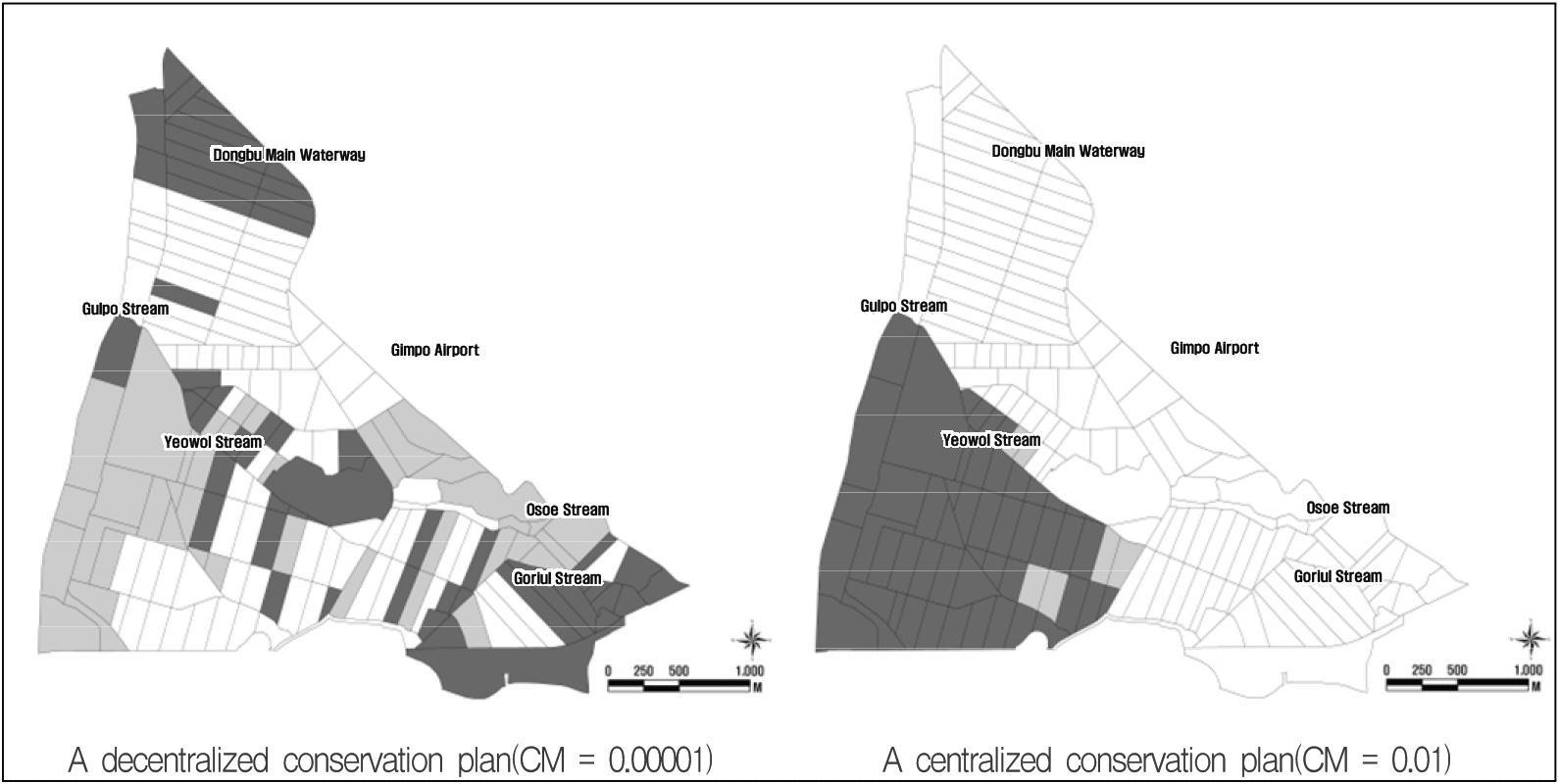
In the case of CM = 0.00001 in Scenario 2, the core conservation area was not concentrated in one area but was distributed in the north of Daejang-dong District and center of Yeowol Stream. Thus, in addition to the Yeowol Stream, the core conservation area was adjacent to numerous small rivers such as the Osoe Stream, Goriul Stream, and Bernae Stream. The core conservation area was also mainly distributed in the area south of the Yeowol Stream, where the protected species index was high. The buffer zone accounted for 28.5% of the total target area and was distributed around the core conservation area. Seoul frog and boreal digging frog, which are protected species, occur in large numbers in Daejang-dong District as its characteristics are suitable for spawning and feeding grounds and hibernation sites. Therefore, it was determined that even if core conservation areas are not intensively distributed, it is possible for species to grow and develop if a sufficient buffer zone is secured from the use zone. Furthermore, the more dispersed the core conservation area, the easier it is to ensure water supply from rivers without creating artificial waterways.
In the case of CM = 0.01 in Scenario 2, the core conservation area was concentrated in one area southwest of Daejang-dong District between the Gulpo Stream and Yeowol Stream. Therefore, the core conservation area is not adjacent to small rivers such as the Osoe Stream, Goriul Stream, and Bernae Stream. The buffer zone accounted for 2.5% of the total target area, which was smaller than the core conservation area. To select and manage habitats in the case of CM = 0.01, areas that are not adjacent to the Yeowol Stream and Gulpo Stream require the creation of an artificial water system, and it is more difficult to create a diverse and stable habitat environment in the case of CM = 0.01 than in the case of CM = 0.00001. The case of CM = 0.01, unlike that of CM = 0.00001, is concentrated in one area, enabling land-use planning and higher space utilization of the use zone (Figure 7).
 A (Core area),
  B (Buffer area),
  C (Use area)
Of the two scenarios, the A decentralized conservation plan was judged as a reasonable plan. Because of the characteristics of public housing district development that are difficult to concentrate green areas in one place and the need for interconnected habitats instead of large habitats for Seoul frogs and boreal digging frogs, which are major protected species in Daejang-dong.
Continuing from a study that previously established conservation management zones in marine ecosystems, river ecosystems, and forest ecosystems using Marxan with Zones, this study proposed a method that can be applied to the paddy wetland ecosystem. Thus, the application of Marxan with Zones has been expanded to a broader range of ecosystems, suggesting the potential for establishing biological habitats and management areas across various ecosystem types in the future. Specifically, setting the planning units posed challenges due to the flat topography of the paddy marshes, which made spatial division difficult. In this study, planning units were based on agricultural waterways, introducing an extended method beyond the traditional units such as grids, hexagons, and watershed areas.
Our study has a few limitations. First, the two derived conservation plans effectively reflected the Biotope index and the distance to rivers index, which serve as mapping indicators; however, the protected species index was not adequately represented, primarily due to the conflicting cost values and the characteristic index. Therefore, in future studies, it is necessary to adjust the Biotope evaluation standard, such as integrating the presence or absence of protected species into the Biotope index and setting only the Biotope where protected species are observed as class I, so that the Biotope index can clearly differ depending on the appearance of protected species.. Second, as human aspects such as culture and landscape were not included in the characteristic indicators, decision-making focused solely on ecological aspects. Future studies on urban paddy fields should incorporate important humanistic indicators with ecological indicators.
5. Conclusions
Daejang-dong District in Bucheon City is a large-scale agricultural ecosystem located adjacent to the Han River with immense ecological value as it provides habitat and food for various types of wildlife. However, its habitats are threatened by the New Town Development Plan and designation of Daejang-dong as a public housing district. The Marxan with Zones program can quantify and synthesize environmental ecological information, create optimal scenarios through iterative processing, and propose reasonable plans. The aim of this study was to construct data on the environmental ecological status of Daejang-dong District and provide an appropriate method for the selection of suitable habitats in paddy fields using Marxan with Zones.
This wetland is frequently flooded before the beginning of paddy cultivation. The Gulpo Stream is the center of the watershed and has created an agricultural system around Daejang-dong District, along with the artificially created Eastern Intracoastal and Dongbu Main Waterway and connected stream. The spawning and feeding grounds and hibernation sites of Seoul frog and boreal digging frog, which are protected species, are distributed along the watershed. Therefore, rivers and agricultural waterways were used as the basis for setting planning units. Spatial structure (e.g., land use and vegetation on waterways) and animal ecology (e.g., wild birds and amphibians) were investigated and analyzed to ascertain the environmental ecological status of Daejang-dong District, and these were reconstructed as input data for the Marxan with Zones program. The environmental ecological status was set as a mapping index. Cost values such as Biotope, distance to rivers, protected species indexes, and the locations and numbers of occurrence of species and individuals were included as characteristic indicators. Based on the analysis using Marxan with Zones, the districts were classified into core conservation areas and buffer and use zones. Three zoning scenarios per target site were prepared by varying the extent of the core conservation area to 20%, 30%, and 40%. Numerical correction was applied to minimize errors in the purpose function values and derive effective values during the analysis using the Marxan with Zones program.
The analysis using Marxan with Zones provided various perspectives for Scenario 2 in which the core conservation area ratio was set to 30% or higher among the three scenarios. A decentralized conservation plan and centralized conservation plan were indicated as solutions. At CM = 0.00001 in Scenario 2, which is the decentralized conservation plan, the core conservation areas were not concentrated in one area, and were distributed adjacent to numerous small rivers such as the Yeowol Stream, Osoe Stream, Goriul Stream, and Bernae Stream. Furthermore, the more distributed the core conservation area, the easier it is to ensure water supply from small rivers without creating artificial waterways. In the case of CM = 0.01 in Scenario 2, which is a centralized conservation plan, the core conservation area was concentrated into one area, and it was not adjacent to small rivers such as the Osoe Stream, Goriul Stream, and Bernae Stream. Therefore,o select and manage habitats in this plan, it is necessary to create an artificial water system in areas that are not adjacent to the Yeowol Stream and Gulpo Stream.
Future research should consider increasing the weight of the protected species indices and reflect the presence of protected species in the Biotope index. The outcomes of the analysis using the Marxan with Zones program can be successfully applied for the selection of appropriate habitats for protected species in urban paddy fields to conserve the ecological environment within the context of urban development.