


1. Introduction
Green infrastructure was initially formalized in August 1999 by the American Conservation Foundation and the USDA Forest Service. and is defined as a network of waterways, greenways, wetlands, wildlife habitats, parks, and other natural areas with services that protect the ecosystem and enhance the quality of human life (McMahon and Benedict, 2000; Walmsley, 2006). As urbanization continues to accelerate, cities face serious environmental and social challenges, such as climate change, urban flooding, ecosystem destruction, and unequal distribution of resources (Barreira et al., 2023; Mohtat and Khirfan, 2023). Related scholars have shown that green infrastructure, as a current important strategy for sustainable urban development, has natural or open space connectivity at the urban physical space level. Concurrently, it is important for improving the urban environment, building a resilient ecosystem, and improving social equity (Kolimenakis et al., 2021; Wu et al., 2023).
Green infrastructure in landscaping mainly includes permeable pavement, green roofs, green walls, green roads, park greenery, etc (Korkou et al., 2023). Moreover, urban roadway greening as linear green space is an important part of the urban green infrastructure (Tomson et al., 2021). In addition, numerous studies have demonstrated the role of urban vegetated ecosystems, especially an increase in trees, in carbon sequestration and storage, as well as air quality regulation and mitigation of the urban heat island effect (Hsieh et al., 2016; Ma et al., 2021; Sprengel et al., 2023). In 1987, the Japanese scholar Yoji Aoki proposed the GVI, which is the percentage area of vegetation within a person’s field of vision (Aoki, 1991). The GVI can be used as a necessary indicator of the availability and layout of urban green spaces. Meanwhile, the GVI includes more greening elements (greening of walls, shrubs growing under trees, and flowers and grasses on the roadside) than the 2D greening coverage (Aikoh et al., 2023). Relevant studies have shown that enhancing the GVI has a positive impact on human psychology, in terms of visual fatigue and stress relief, while also improving the urban environment (Jiang et al., 2016; Elsadek et al., 2019). Therefore, studying the GVI of roads provides some research implications for the development of urban green infrastructure.
This study is centered on the downtown area of Chengdu City, Sichuan Province, China, and includes several research objectives 1) To analyze the GVI level of urban roads and the spatial distribution characteristics of different grades of GVI in the scope of the chosen metropolitan area, and to identify the interrelationships with the green space system of urban parks; 2) to analyze the characteristics of roads with a low GVI in different areas; 3) to analyze the interconnectivity between road facilities and the road GVI from the point of view of urban traffic and concentration of pedestrian flow. This study was performed on the basis that the GVI of the roads in Chengdu is proposed to be improved by combining the concept of green infrastructure.
2. Theoretical Study
Kim and Son (2012) performed a related Korean study, which used green infrastructure planning and policy in the UK, as a case study to illustrate that the development of green infrastructure in the urban planning system needed to be implemented nationally, regionally, and locally. Sung (2012) explored green infrastructure as a composite system of urban green spaces, and demonstrated the technical aspects of green infrastructure through the intrinsic functions of green spaces, especially the ability of water recycling and the enhancement of self-evolution through plants. Kim (2014) suggested that the implications of building a sustainable urban water cycle management strategy could improve green infrastructure development in Korea, using current green infrastructure policies in the United States. Lee (2020) analyzed the relationship between economic losses due to urban flooding and the spatial pattern and development patterns of green infrastructure through satellite images, using seven highly developed cities in South Korea as target sites.
Related foreign studies, such as Black and Richards (2020), showed that urban green space as green infrastructure, by centering on the High Line Park in New York, demonstrate that an increase in the green space areas in the city will lead to an increase in the value of regional properties. Dong et al. (2022) optimized the urban green infrastructure network through remote sensing imagery to improve green roof designs centered on a typical high-density urban area within the Fifth Ring Road in Beijing, China. Yen et al. (2023) considered the transportation infrastructure system in the city, using the accessibility of green infrastructure as an important indicator, to analyze the impact of green infrastructure on house prices, using multiple regression models and the Gold Coast, Queensland, Australia as an example. Wu et al. (2023) analyzed the equity of access to green infrastructure across different regions and populations during the COVID-19 outbreak, centering on Salt Lake County, USA, and used regression analysis to evaluate the potential influencing factors. Mohtat and Khirfan (2023) analyzed the selection of sites for climate-resilient green infrastructure in flood-prone areas from a climate justice perspective by combining a questionnaire survey with a participatory mapping exercise for residents in the Sankliffe Park area of Toronto, Canada.
The GVI was initially studied in environmental psychology and has gradually become one of the regular greening evaluation indexes recognized by the Japanese government (Tonosaki,2010). Kim et al. (2014) used psychometric tools to determine the psychological changes induced by variations in the GVI in landscape planting spaces. Ki and Lee (2021) examined the relationship between the GVI of urban streets and walking activity among different income groups based on data from a walking behavior survey of residents in Seoul, South Korea. Aikoh et al. (2023) validated the accuracy of calculating the GVI using Google Street View images and image segmentation techniques by comparing it with traditional methods.
In summary, previous studies suggest that research should be related to green infrastructure, such as parks and green spaces, urban flood management, social justice, and accessibility. In addition, studies on the GVI mainly focus on greening indicators, psychological perception, walking activities, and technological innovations. Unlike previous studies, this study takes into account the connectivity of street green spaces as urban green infrastructure in terms of physical space with natural open spaces such as urban green spaces, as well as ecological and social effects in terms of low-impact development and response to the climate crisis. Therefore, using the GVI of urban streets as an indicator, this study will analyze the level of GVI of urban streets and the characteristics of spatial distribution, as well as the correlation between GVI and urban parks, and green spaces, and transportation network systems.
3. Research Scope and Methodology
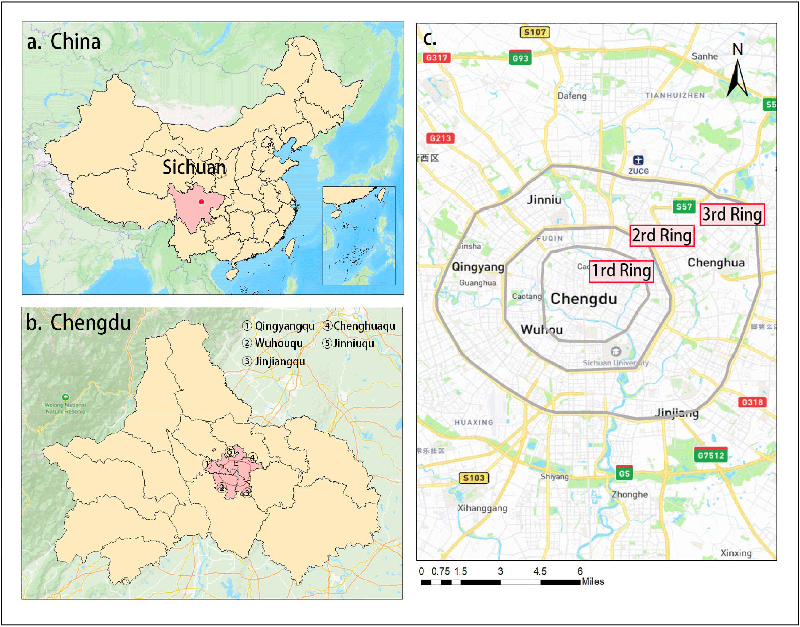
Chengdu is located in the western part of the Sichuan Basin and is an important center city in the center of the Sichuan Province in the western region of China. Located in a humid subtropical region and rich in biological resources, it has a subtropical monsoon climate with relatively warm winter temperatures, with January temperatures above 5°C. The average annual temperature is 16°C and the annual rainfall is about 1,000 millimeters. In the early 21st century, the Chengdu government defined all areas within Chengdu’s 3rd Ring Road as the central urban area, which then was expanded over the following decades, and reached a built-up area of 1,064 square kilometers and a population of 15.42 million by 2022(https://baike.baidu.com/item/成都). Thus, as the main place for socioeconomic occurrences in urban development, this study chose the area within the 3rd Ring Road of Chengdu City as the study area(Figure 1).
The Baidu Street View Images (BSVIs) are street view image features based on Baidu Maps, developed by the Chinese Internet company Baidu. A large number of image datasets from representative cities in China can be accessed relatively easily without geographical restrictions (Chen et al.,2019). Relevant studies have shown that the current BSVIs has been widely utilized in research on urban street quality, the built environment, and other areas (Wang et al.,2022). On this basis, the research process in this study, was to first, obtain the Street View image data using the BSVIs Application Programming Interface(API) calls. Second, the Street View image data were segmented using a deep learning semantic segmentation technique to extract green plant elements for the GVI calculation. Third, Arc GIS was used to analyze the spatial distribution of the street GVI and the characteristics of the low GVI streets. Fourth, the linkage between the streets and the GVI was analyzed by applying global integration through space syntax.
In this study, to calculate the GVI of a street, the street view image data were acquired from the BSVIs. The specific steps for acquiring these street images are shown in Figure 2 are as follows:
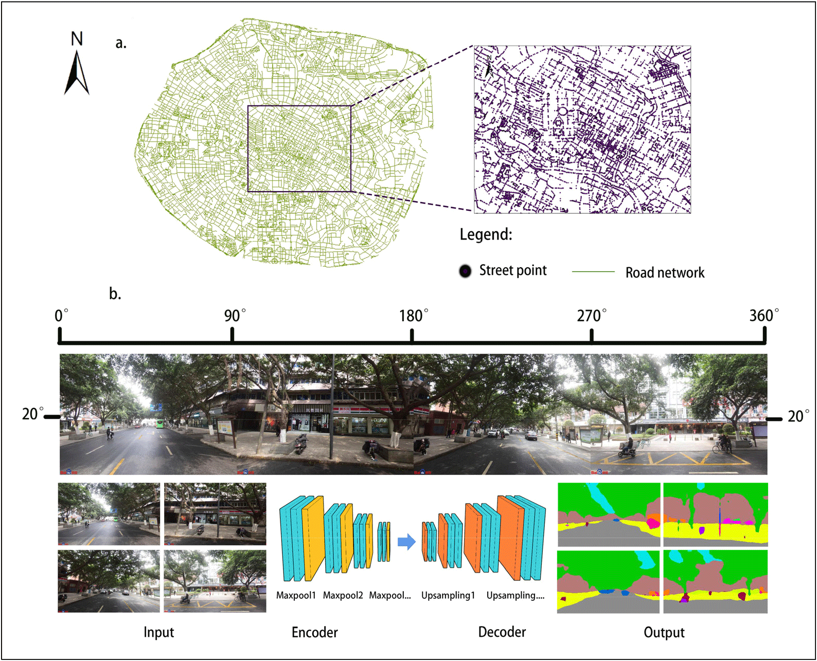
First, the road network was downloaded from the Open Street Map (OSM), and the road network was tailored to the Third Ring Road of Chengdu City in Arc GIS. The panoramic street images were established and generated in the cropped road network at intervals of 50 meters. A total of 85,299 sample collection points were established from the street network within the Third Ring Road.
Second, the BSVIs service API is used to request the return of street images corresponding to the collection points in the form of HTTP URLs. By setting the given adjustable API parameters, we constructed the URL parameters sent by the standard HTTP request to obtain the static street image by limiting the direction and angle of the human’s viewpoint. The HTTP URL takes the following form:
In the BSVIs parameter settings, (location) represented the geographic latitude and longitude coordinates of the street view collection point. In this study, the obtainable image size was set to a maximum of 900 × 600 pixels, the width of the field of view (fov) of the representative person was set to 90°, and the street image was acquired from four different starting angles; 90°, 180°, 270°, and 360° of the (heading), while the pitch angle of the field of view (pitch) for the representative person was set to 20° to fit the person’s viewing angle (Wang et al.,2022).
Third, the street view image, which is stitched together from four images with a size of 900 x 600 pixels, provided a complete representation of the surroundings. The coordinates of the sampling points were input into Python program. A total of 341,196 images (including blank street view images crawled from invalid coordinate points) were downloaded and stored, while 85,299 street view images were merged. The street view data will be used for image semantic segmentation and to calculate the GVI.
In this study, the extraction of green plant elements in street view images was performed using the semantic segmentation technique with computer vision technology. Cityscapes was selected as the training dataset. The Cityscapes dataset is an open dataset that is widely used in computer vision research, mainly for semantic segmentation, instance segmentation, and scene understanding tasks. This dataset contains thousands of high-resolution images of street scenes, roads, buildings, vehicles, pedestrians, and more in an urban environment. The openness and richness of the Cityscapes dataset make it one of the most important resources for the research and development of computer vision and deep learning models, while it is currently widely used in urban spatial awareness, street environment analysis, and other research studies (Han et al.,2022).
The segmentation model SegNet was chosen in this study to achieve accurate pixel-level segmentation of object elements in the target image. SegNet is an open-source project for image segmentation, which was developed and released in 2015 by a team at the University of Cambridge. SegNet consists of two main elements: an encoder and a decoder. The encoder compresses and extracts the object information, and the decoder reduces the extracted semantic information to the size of the input image(Han et al.,2022). Moreover, each pixel can be classified into its corresponding object information and represented by its color. In this study, the plant elements (trees, grass) in the streetscape images were mainly selected.
In this study, the street GVI was calculated using the segmented photographs. By definition, the GVI is the percentage of the field of view at a given location where green plants are observed (Yu et al., 2021). The image can be calculated using the image pixel occupancy ratio, which is 0.00% GVI when none of the pixels in the image are classified as plant elements and 100% GVI when every pixels is a plant element.
This study used the five-segment evaluation method for the GVI, which was proposed by the Japanese scholar Natsuki Obihara (Orihara, 2006) to be the division standard: GVI less than 5% is poorly perceived; 5%-15% is poorly perceived; 15%-25% has some greenery; 25%-35% has more greenery; more than 35% has good greenery. The formula for calculating the GVI in this study is as follows:
where the GVI is the proportion of green pixels in the four images and i is the number of images, this study has four images according to the street viewpoint.
Integration is the degree of agglomeration and disagglomeration between one element and the others in a spatial system and measures the ability of a space to attract arrival traffic as a destination, thereby reflecting the centrality of the space in the overall system and the degree of connectivity between spaces. Hillier suggests that areas with global integration in the top 10% can be judged in space syntax as being central(Hillier and Iida, 2005). The degree of global integration was found to be closely related to the overall spatial structure of the city and has been widely used in studies of urban land prices, commercial centers, and urban crime rates(Kim and Kim., 2012). In this study, the use of global integration allows us to determine the linkage between urban centers (areas where vehicular and pedestrian traffic are most likely to congregate) and the GVI of streets.
4. Results and Discussion
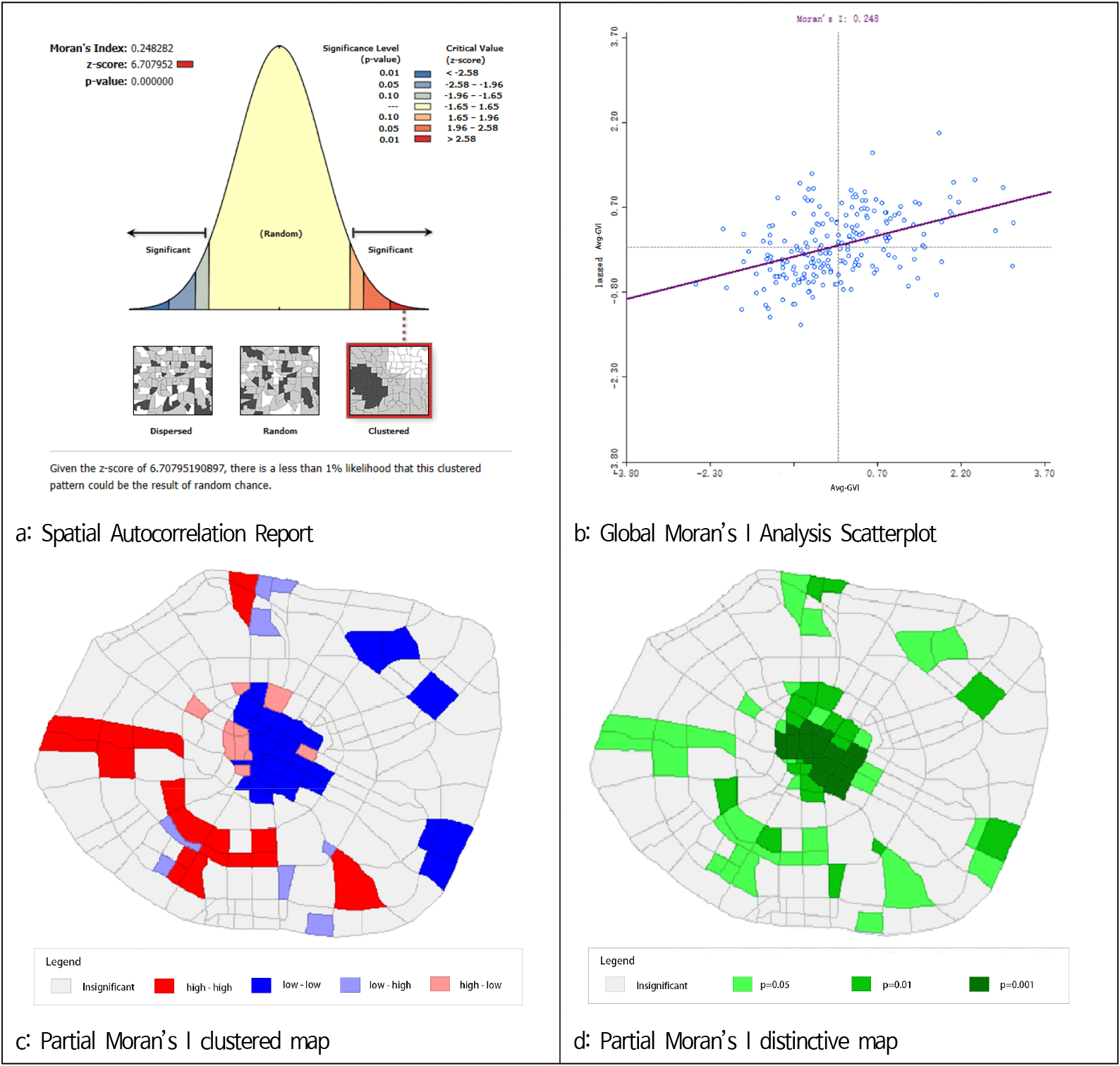
According to the “first law of geography”, everything is spatially correlated, while the closer things are the greater the spatial correlation. Spatial statistics generally utilize spatial autocorrelation indices to reflect spatial dependence, i.e., the degree of interdependence between the data at different locations and the data at other locations. The analysis of spatial autocorrelation makes it possible to analyze the properties of the phenomenon of spatial distribution of spatial elements in space. Therefore, Moran’s I was used in this study to analyze the GVI distribution of streets within the Third Ring Road in Chengdu City and its correlation with the internal area. The results of the analysis are as follows.
First, global spatial autocorrelation analysis was performed using the spatial autocorrelation function in Arc GIS (Figure 3(a)-(b)). Where Moran’s I uses the range of [−1,1], while when the index is greater than 0, it indicates a positive correlation, and when it is less than 0, it indicates a negative correlation. Based on the results of the analysis, a global Moran’s I value of 0.248 (>0) was derived for the study area, meaning it can be concluded that the overall spatial extent of the GVI distribution is positively correlated. Second, local spatial autocorrelation analysis is needed to understand the clustering of the high and low GVI values in different areas (Figure 3(c)-(d)). The results show that the red portion was a highly clustered area, with high and high GVI values in the perimeter. It is mainly concentrated in the Jinniu(金牛), Qingyang(青羊) and Wuhou(武侯) districts outside the First Ring Road of the city. The blue part is the agglomeration area of low value. The Jinjiang(锦江) and Chenghua(成华) districts are mainly located within the First Ring Road and the Third Ring Road.
There were a total of 76,451 points for which the GVI results were obtained in this study following the exclusion of the points that were not present in the streetscape. The minimum GVI for all the streetscape points was 0.00%, the maximum value was 89.62%, the median was 20.27%, the mean was 22.88%, and the standard deviation was 16.39. According to the Japanese scholar Natsuki Ogihara’s five-level classification standard, when the GVI was 15-25%, the people’s perception of the GVI was evaluated as ordinary.
According to the classification standard of the GVI level, this study combined the method of kernel density analysis in the Arc GIS to calculate the spatial distribution characteristics of the different level standards of the GVI in the Third Ring Road in the Chengdu city center(Figure 4 (a)-(e)). First, the number of street spots with a GVI of ≤5% was 10,630, or 13.9%. The most densely distributed areas in the spatial distribution characteristics are concentrated in the Chengdu International Financial Center (CIFC), with surrounding commercial areas within the First Ring Road of the city(Figure 4 (a)). Secondly, the number of street spots with a GVI of 5-15% is 18,654, or 24.4%, which is the largest share of all the street spots. The spatial distribution characteristics are relatively balanced, and the relatively densely distributed areas are mainly concentrated in the First and Third Ring Roads of the city(Figure 4 (b)). Third, the number of street spots with a GVI of 15-25% was 16,599 or 21.7%, while there are no areas of significant aggregation in the spatial distribution characteristics(Figure 4 (c)). Fourth, the number of street spots with a GVI of 25-35% was 13,395, or 17.5%. The spatial distribution characteristics of the GVI show a clear trend in the clustering toward the southwest(Figure 4 (d)). Fifth, the number of streetscape locations with a GVI of ≥35% was 17,173, or 22.5%. The spatial distribution characteristics of the high GVI are not characterized by significant clustering in the northeast compared to the southwest(Figure 4 (e)). By analyzing the reasons, it was hypothesized that this spatial distribution characteristic may be related to the history of urban development and economic and industrial structures. Located in the northeast, Chenghua District was originally a township area in the Dongcheng(东城)District and Jinniu District of Chengdu, forming a suburb of the city, as well as an area of concentrated development for old industries(https://baike.baidu.com/item/成都).
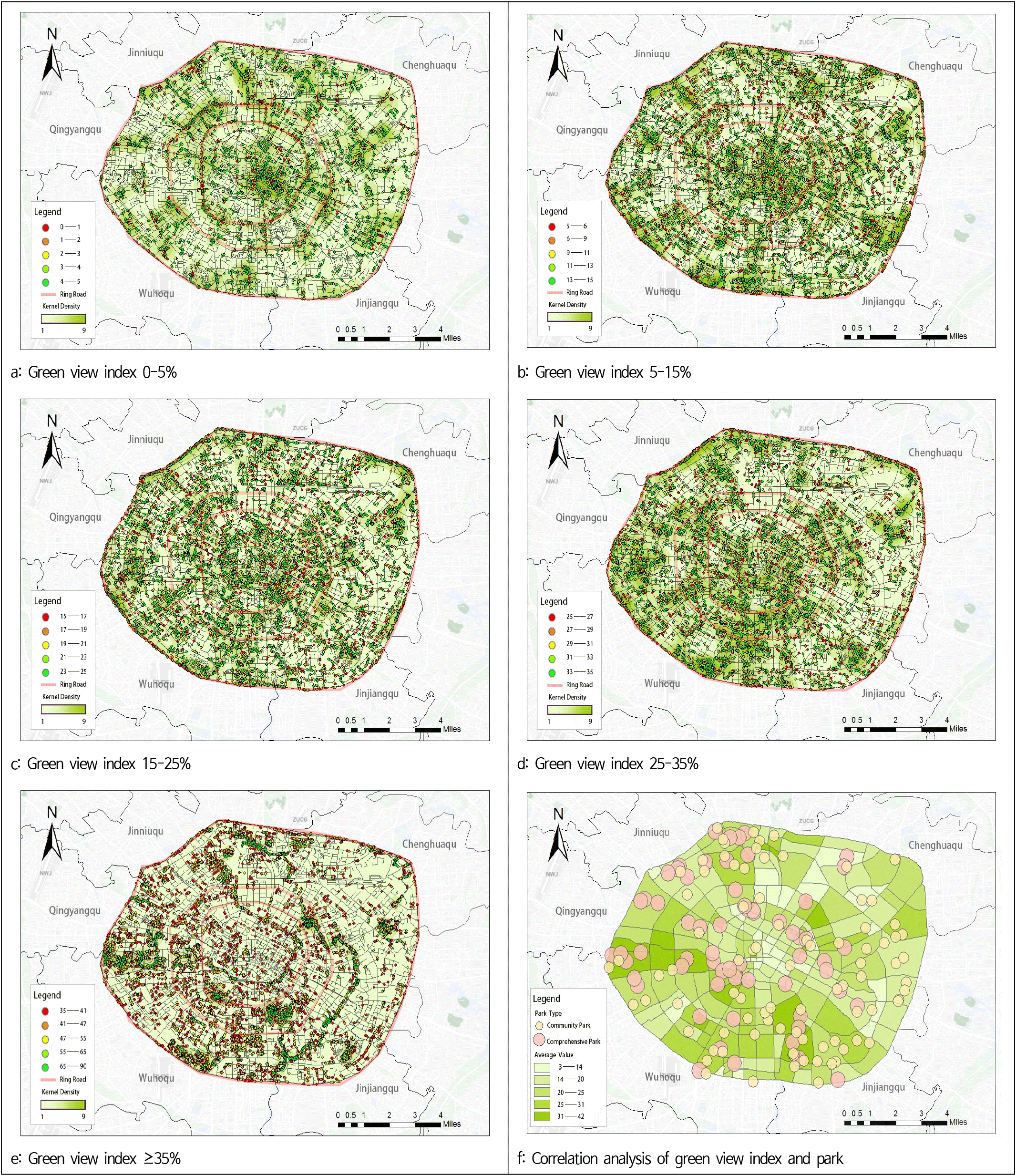
On this basis, this study utilized Python to obtain POI data1) on urban parks and green spaces from the Baidu map to overlay and analyze the average GVI within the different street areas(Figure 4 (f)). A bivariate correlation analysis between the mean GVI of the 205 street areas selected within the study area and the number of parks and green spaces within the area was also conducted by SPSS 22.0, and resulted in a Pearson’s correlation coefficient of 0.333** (>0) and a sig value of 0.000 (<0.05) (Table 1). Therefore, it was judged that the spatial distribution of the GVI has a certain correlation with the number of urban parks and green spaces, i.e., the level of GVI is higher in the street area of the region with a large number of parks and green spaces.
| Factor | Green view index | Park |
|---|---|---|
| Green view index | 1 | 0.333** |
| Park | 0.333** | 1 |
| Sig. | 0.000 | |
In this study, a random sampling method was used to select the streetscape images for analysis from streetscapes with a maximum GVI of 25% (Figure 5). Streets with a low GVI were analyzed and classified into the following two main types.
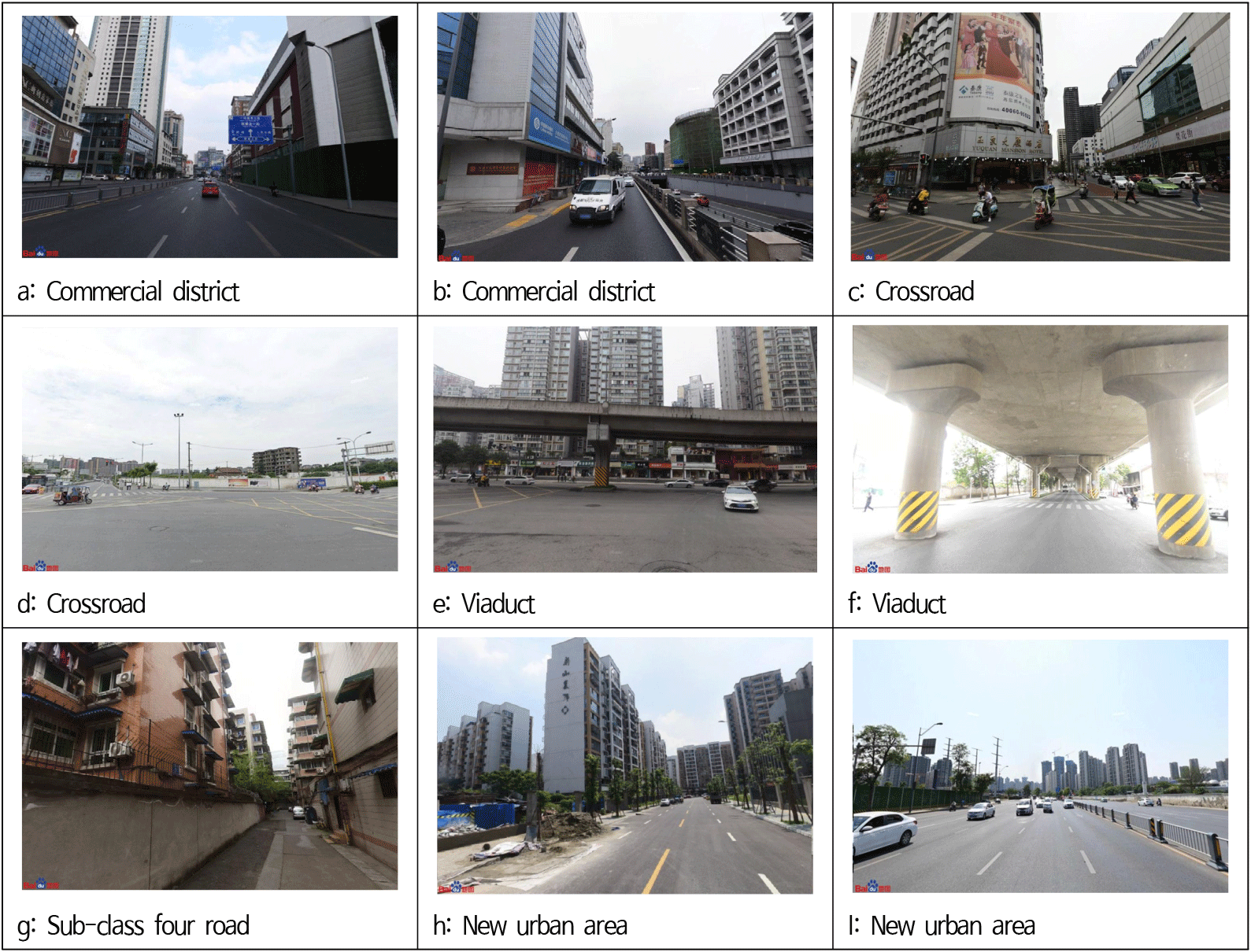
First, according to the type of area, the low GVI areas in the city were mostly commercial facilities, gathering areas, and areas of new construction, Thus, the reasons for this were analyzed; 1) Commercial facilities agglomeration areas are usually dominated by dense buildings, parking lots and other facilities, with less green space. 2) Newly constructed urban areas are usually in the early stages of urban construction, and newly cultivated green plants are still in the growth stage, with smaller tree crowns, thereby leading to a lower GVI on the streets.
Secondly, low GVI roads, according to the road type, are mostly the areas above and below the viaducts that surrounding the area, the areas of roads below the city’s fourth level (7.0-6.5m), and the crossroad of the city’s main roads. The analysis of these reasons was 1) the viaduct area considers the safety of vehicular traffic, whereby a large number of trees and plants cannot be planted above the road surface, while the impact of the building structure is not reasonably utilized in the road below, nor can it be planted in the green space, thereby resulting in a low GVI. 2) Sub-class four roads are restricted in green planting due to their relatively narrow width and the narrow space enclosed by the buildings and fences. 3) The crossroad of the city’s main roads maintains a low spatial GVI to a certain extent, thereby considering and maintaining the safe sightlines for vehicles and pedestrians, as well as the installation of facilities, such as traffic signals and sidewalks.
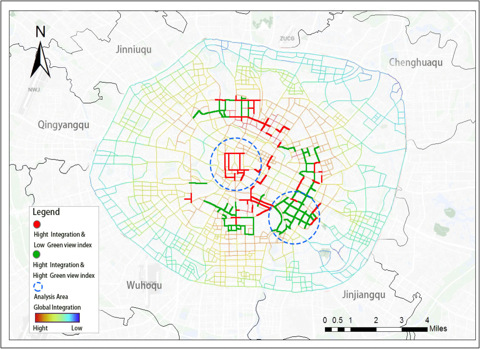
As a crucial component of the city’s gray infrastructure, urban streets can both play essential socioeconomic roles, including transportation and commercial logistics, and also serve as spaces for residents to interact and relax in their daily lives, amid the surrounding buildings and roadside plants in their daily lives(Ye et al.,2019; Wang et al.,2022). Therefore, in this study, from the perspective of the centrality of road traffic in the overall region, the integration degree of roads within the Third Ring Road of Chengdu City was superimposed on the GVI of roads through the global integration degree calculation in the space syntax. The results of the analysis are as follows.
First, in this study, roads with the top 10% of values in global integration were considered high integration roads. whereby, the areas where vehicles and people are most likely to congregate, were mainly within the city’s second ring road (Figure 6). Among them, 1) the red areas indicated the streets with high integration and low GVI, which were mainly concentrated in the central area of the First Ring Road, for example: Dongchenggen(东城根)Street and Xihuamen(西华门) Street, Xiyulong (西玉龙)Street, among others. These streets are affected by factors such as dense commercial building facilities, restricted land use space, and expensive prices, and thus, have a low level of road greening. 2) The green areas for the high integration and the high GVI streets are mainly concentrated in the city, within the Second Ring Road area of Sichuan(四川) University and along the Jinjiang(锦江) River, as well as in the area around Wangjianglou(望江楼) Park, for example: Wangjiang(望江) Road, Longzhou (龙舟)Road, and Shunjiang(顺江) Road, among other streets. The roads have a high level of greening because they are located around campuses, rivers and parks.
5. Conclusion
Based on the theory of green infrastructure, this study measured the GVI of roads within the Third Ring Road of Chengdu city by using BSVIs and SegNet semantic segmentation technology. The spatial distribution characteristics of the roadway GVI, low GVI street characteristics, and interconnectivity with parks and roadway facilities were analyzed by using Arc GIS and space syntax and the results are as follows:
First, the average value of the overall GVI within the study area was 22.88%. According to the delineation criteria, a GVI of 5-15% represents the highest percentage. Moreover, considering the spatial distribution characteristics, the GVI was higher in the southwest than in the northeast, while the urban construction development in the Chenghua(成华) District, situated in the northeast, has progressed relatively slowly. Simultaneously, analyzing the connectivity with park green space facilities revealed a correlation between streets with a high GVI and the distribution of green spaces in urban parks.
The results of this study imply that the GVI of urban streets is to some extent unevenly spatially distributed, with a high GVI being more concentrated in areas that are rich in green space resources. From the perspective of environmental equity, urban green space is a public service that should be equitably enjoyed by all urban residents (Shen et al.,2017; Wu et al.,2023). The unequal distribution of the GVI on the streets may trigger environmental and health inequalities (Ye et al.,2019; Ki and Lee, 2021). Therefore, in the future, it is necessary for the Chengdu government departments and urban designers to prioritize the implementation of street GVI enhancement measures and management of policies by targeting areas with a low GVI.
Second, the street areas with a low GVI within the study area are concentrated in areas of the city with a high density of commercial facilities, new construction areas, areas around elevated roadways, the city’s fourth level (7.0-6.5m), and the crossroad of the city’s main roads. The Japanese scholar Yoshinobu Ashihara once mentioned in his book entitled Street Aesthetics, that “streets are the mark by which tourists evaluate a city.” Thus, in urban street design and beautification, full consideration should be given to the relationship between the street width and the scale of surrounding facilities. The area within the Third Ring Road of Chengdu is the center of the city’s economic and social development yet faces the problem of dense building facilities and limited green space. Relevant studies have previously shown that urban street facade greening has the effect of beautifying the urban environment, lowering the temperature of the city, and enhancing the GVI(Wong et al.,2010; Hunter et al.,2014; Alsaad et al.,2022). Recently, it has become a common practice in many cities, such as the “urban forest” projects in Singapore and Malaysia; and in government departments for areas such as Beijing and Shenzhen to promote the greening of urban rooftops and walls through the issuance of building codes and design guidelines (Peng et al., 2020). These measures have some reference value for improving the GVI of the streets in Chengdu City in the future.
Third, this study analyzed the concentration of road traffic and people’s activities in Chengdu, and concluded that highly integrated streets are mainly concentrated within the Second Ring Road of the city, whereas highly integrated and low GVI areas are mainly concentrated within the First Ring Road of the city. Moreover, highly integrated and high GVI areas are concentrated within the Second Ring Road, in areas around campuses, rivers, and parks and green spaces. This result indicates that the connectivity of roads and green infrastructure still needs to be improved in the urban transportation center area. Urban roads, such as urban transportation networks, are the main spaces that connect residents’ daily lives with other facilities in society. Therefore, on this basis, it is expected that in the future construction of the urban green infrastructure networks in Chengdu, attention should be paid to the improving the green environment of streets in areas with high integration degrees but a low GVI.
However, this study also has the following limitations. First, although the use of Street View images were used to analyze the GVI, these are more convenient and efficient compared to the traditional method of manually measuring the GVI due to the limitations in the collection time and weather, the seasonal changes by plants in different weather conditions will, to a certain extent, affect the measurement of the GVI value. Therefore, the use of BSVI Historic Street View and Google Street View will be considered in future research to advance the time dimension.
Second, this study analyzed the balance in the spatial distribution of the Street GVI, and the connectivity between the urban parks and roads. However, the assessment of the GVI does not provide a multifaceted analysis of the influencing factors, such as the urban climatic environment, socioeconomic factors, etc. Thus, more environmental factors will be considered in future studies.